Weather
Severe Thunderstorms, Hail, Wildfire Smoke, And Extreme Heat: Wednesday In PA
A storm capable of inflicting significant damage threatens this afternoon.


Extreme, life-threatening heat will arrive in region Wednesday, with severe thunderstorms, damaging wind and hail possible later in the day, forecasters said.
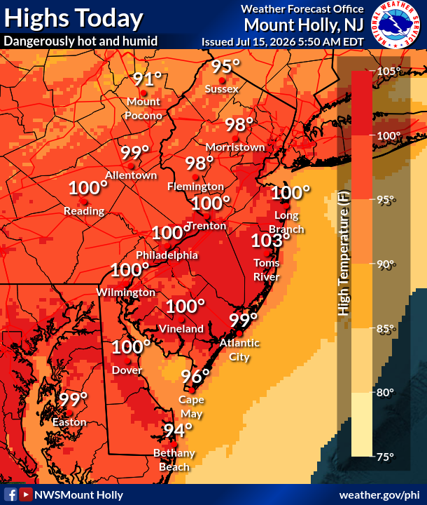
The day will see high temperatures reach about 100 degrees throughout much of southeastern Pennsylvania, according to the National Weather Service.
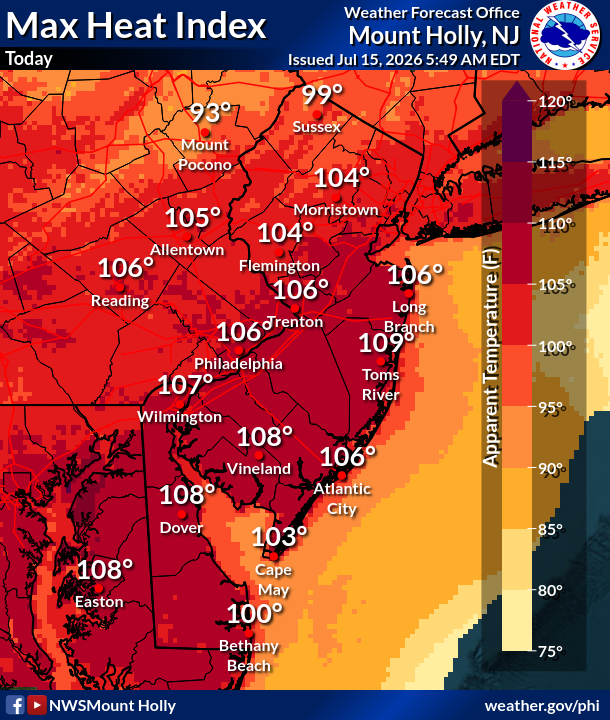
The heat index, meanwhile, is expected to soar to around 106. That's well beyond the life-threatening threshold. Heat-related illnesses are possible. Groups sensitive to heat are at extra risk.
Find out what's happening in Across Pennsylvaniafor free with the latest updates from Patch.
"It is recommended that residents, who are able, remain indoors during peak heating hours, early this week," AccuWeather Meteorologist Brandon Buckingham said. "If you have to be outside, consider taking numerous breaks, utilizing shaded areas, wearing light-colored clothing, and staying hydrated."
The only relief could come in the form of severe storms. Thunderstorms threaten from 4 p.m. to 11 p.m., with hail, heavy rainfall, windfall, and lightning possible.
Find out what's happening in Across Pennsylvaniafor free with the latest updates from Patch.
Damaging winds are the greatest threat from this front, the National Weather Service says.
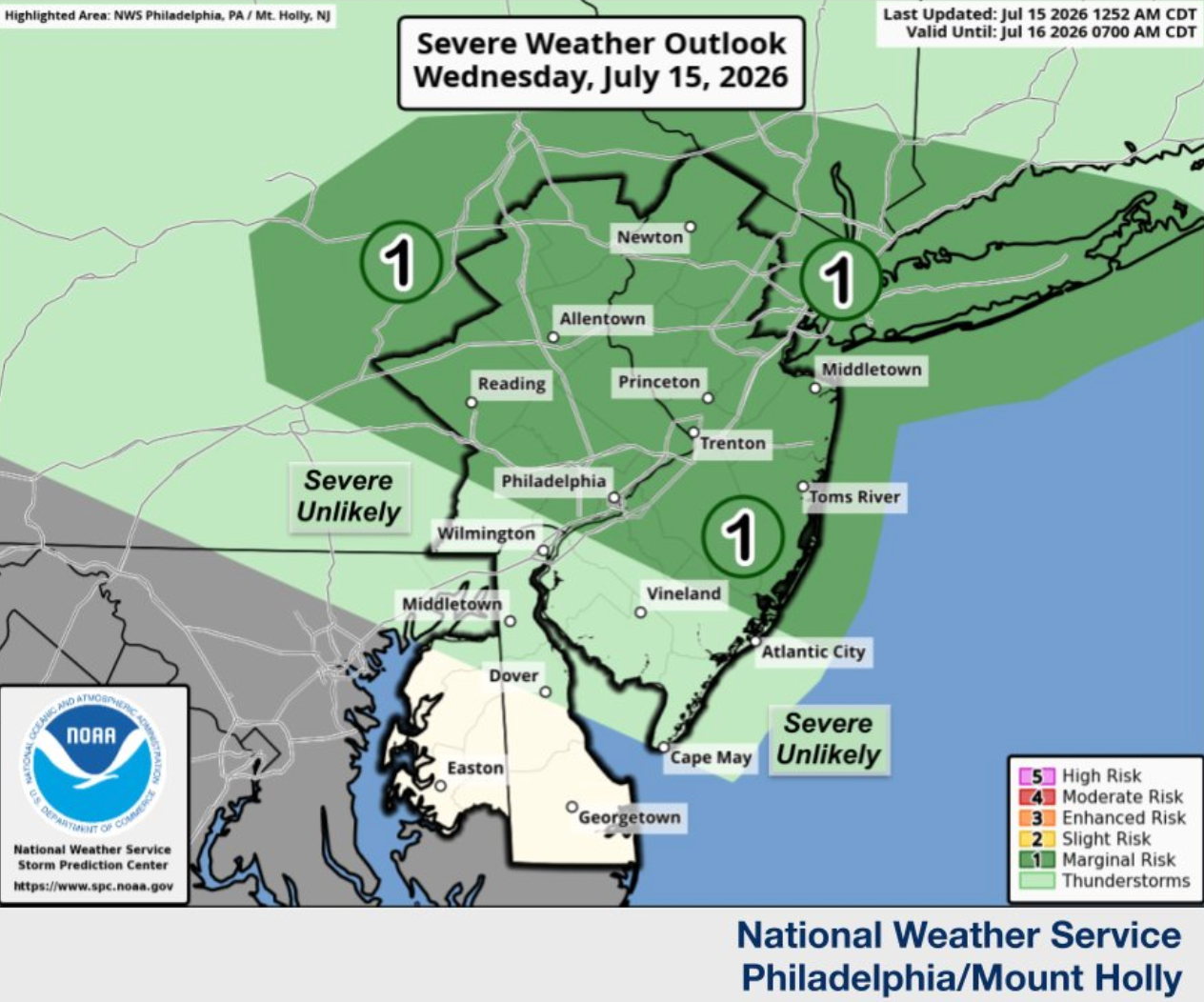
Forecasters are currently describing the thunderstorms as isolated, with a "marginal" risk for the region. Residents should monitor for alerts in the later afternoon and evening hours as the front takes shape.
Wednesday may be the hottest day of this heat wave, though conditions will deteriorate in other ways in the coming days. To compound the heat, wildlife smoke from Canada is floating on its way south, and will arrive Thursday, becoming widespread by Thursday night and possibly moving out by Friday.
High temperatures will still reach 96 Thursday and 92 Friday before tapering off into the upper 80s by the weekend. More showers and thunderstorms are possible later Friday and Saturday.
Here's the full forecast for the week ahead, according to the National Weather Service:
Wednesday
Sunny and hot, with a high near 100. Heat index values as high as 106. West wind 5 to 15 mph.
Wednesday Night
A slight chance of showers and thunderstorms before 9 p.m. Widespread smoke, mainly after 1 a.m. Partly cloudy, with a low around 77. West wind 5 to 10 mph becoming north after midnight. Chance of precipitation is 20 percent.
Thursday
Areas of smoke. Mostly sunny, with a high near 96. Light northwest wind becoming west 5 to 10 mph in the morning. Winds could gust as high as 25 mph.
Thursday Night
Widespread smoke, mainly before 9 p.m. Mostly clear, with a low around 75. West wind around 5 mph becoming calm after midnight.
Friday
Mostly sunny, with a high near 92. North wind around 5 mph.
Friday Night
A chance of showers and thunderstorms after 2 a.m. Mostly cloudy, with a low around 73. Chance of precipitation is 40 percent. New rainfall amounts of less than a tenth of an inch, except higher amounts possible in thunderstorms.
Saturday
A chance of showers and thunderstorms, then showers and possibly a thunderstorm after 8 a.m. High near 87. Chance of precipitation is 80 percent.
Saturday Night
Showers likely and possibly a thunderstorm before 2 a.m. Mostly cloudy, with a low around 71. Chance of precipitation is 70 percent.
Sunday
Mostly sunny, with a high near 87.
Sunday Night
Partly cloudy, with a low around 69.
Monday
Mostly sunny, with a high near 88.
Monday Night
Partly cloudy, with a low around 71.
Tuesday
A chance of showers and thunderstorms. Partly sunny, with a high near 90. Chance of precipitation is 50 percent.
Get more local news delivered straight to your inbox. Sign up for free Patch newsletters and alerts.