Weather
New Storm System Targets Philly Region
A highly variable winter system is heading toward the region, which forecasters say could miss entirely or could bring some notable impacts.

A new storm system is tracking toward the greater Philadelphia region which could bring additional wintry impacts to the area.
The front remains highly variable, but if it does continue its track towards the mid-Atlantic region it would likely strike on Sunday evening, according to the National Weather Service. Rain, snow, and ice are all possible.
The storm is currently heading east across the middle of the country. Depending on conditions, it could head straight east and out into the sea, meaning the local area would receive no impacts whatsoever, according to forecasters.
Find out what's happening in Across Pennsylvaniafor free with the latest updates from Patch.
However, it may also turn north along the coast and up through the mid-Atlantic states and New England. Accuweather said.
"It will likely not be cold enough in the coastal cities of the Northeast, from Washington, D.C., to Boston, to support a major snow or ice event," AccuWeather senior director of forecasting operations Dan DePodwin said in a statement. "However, some snow and ice is possible in this area, especially from New York to Boston."
Find out what's happening in Across Pennsylvaniafor free with the latest updates from Patch.
While major accumulation appears unlikely, there could still be significant impacts because of the snowpack existing on the ground. This causes warmer air to take longer to reach the ground, according to forecasters.
"This can increase the risk of ice, especially when precipitation begins, even if the majority of the event is rain," DePodwin added.
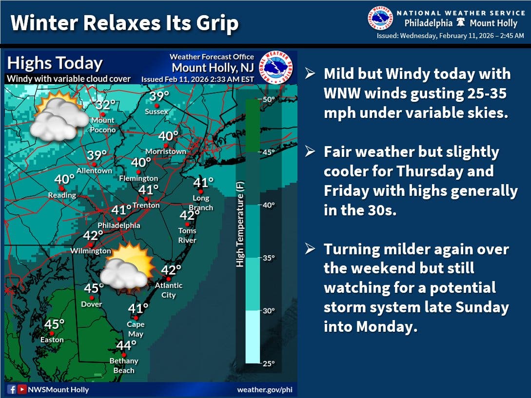
Meanwhile, over the next several days, warmer weather is expected, with highs reaching the low 40s on Saturday and Sunday.
Forecasters believe they'll have a better handle on the track of the storm and potential impacts in the coming days.
Here's the full forecast, according to the National Weather Service:
Wednesday
Partly sunny, with a high near 41. Breezy, with a northwest wind around 20 mph, with gusts as high as 30 mph.
Wednesday Night
Mostly clear, with a low around 27. West wind around 15 mph.
Thursday
Partly sunny, with a high near 36. Northwest wind 10 to 15 mph.
Thursday Night
Partly cloudy, with a low around 20. Northwest wind 5 to 10 mph.
Friday
Sunny, with a high near 36. Northwest wind around 5 mph.
Friday Night
Mostly clear, with a low around 27.
Saturday
Sunny, with a high near 42.
Saturday Night
Mostly clear, with a low around 25.
Sunday
Mostly cloudy, with a high near 41.
Sunday Night
A chance of rain and snow. Mostly cloudy, with a low around 33. Chance of precipitation is 40 percent.
Monday
A chance of rain. Mostly sunny, with a high near 45. Chance of precipitation is 30 percent.
Monday Night
Partly cloudy, with a low around 33.
Tuesday
Partly sunny, with a high near 47.
Get more local news delivered straight to your inbox. Sign up for free Patch newsletters and alerts.