Weather
Snowstorm Aftermath In Philly Region: SEPTA Shut Down, Roads Status, Flights Canceled
The powerful storm brought much of the country grinding to a halt Sunday. Here's what you need to know.

A powerful winter storm swept through the greater Philadelphia region on Sunday, dropping 8 to 12 inches of snow throughout the area and causing severe travel impacts. Here's what you need to know.
Roadways
While the snow has stopped falling, drivers are advised to still stay off the roads if they can, the Pennsylvania Emergency Management Agency said early Monday.
Find out what's happening in Across Pennsylvaniafor free with the latest updates from Patch.
While plows are working to clear major routes, travel remains treacherous in many places.
State officials said that some 4,700 road workers and 2,600 plow trucks were out on the roads as of late Sunday.
Find out what's happening in Across Pennsylvaniafor free with the latest updates from Patch.
Speed limits remain reduced to 45 miles per hour on many highways around the state, including I-76, I-95, I-295,I-474, and I-676.
U.S. Routes 1, 30, 202, 422, as well as State Routes 63, 100 Spur, and 309 are also impacted.
The City of Philadelphia alone said they experienced 811 EMS incidents on Sunday.
Daily totals for Sunday, January 25:
🚑: 811 EMS incidents
🚒: 218 fire incidents
🔥: 3 working fires #24x7x365 pic.twitter.com/2WL4SPPttb
— Philadelphia Fire (@PhillyFireDept) January 26, 2026
Pennsylvania State Police said they responded to six vehicle crashes and 98 disabled vehicles Sunday.
PennDOT said there were 8,329 crashes, 29 fatalities, and 2,959 injuries in crashes on snowy roadways last winter alone.
Snow Totals
In the Philadelphia suburbs, the areas that received the highest accumulation include communities in Chester, Montgomery and Bucks counties. In Gardenville, Bucks County, 12 inches fell. And in Malvern, 12.5 inches fell. Skippack in Montgomery County received 12.2 inches. See the full list of snow totals here.
SEPTA shut down
All of SEPTA's regional rail and bus routes remain shut down early Monday after the storm, as crews work to clear snow, de-ice tracks, and prepare trains and vehicles for services.
City trolleys T and G are also shut down.
"Crews are working to gradually restore service for today," SEPTA shared in a statement. "When it is safe to do so, Regional Rail will operate on a Saturday schedule on Monday only."
Although SEPTA did not provide a specific time for when they will resume full service, they said they "hope" to resume regional rail trains by midday Monday.
If buses and metro routes resume, they will operate on a Monday schedule.
Some selected SEPTA lines are operating as normal Monday, with the Norristown High Speed Line, Market-Frankford Line, and Broad Street Line all offering service.
Power outages
The Philly region was largely spared from power outages, however. While there were some minimal impacts, there were only 24 outages scattered around the entire five county area, as of Monday morning, according to PECO.
Those outages were focused in west Philadelphia, which accounted for nearly 20 of them. A total of 269 customers were impacted.
Philadelphia International Airport
Philadelphia Airport remains open. However, nearly all of its flights were canceled on Sunday, with only a tiny handful of planes able to take off in the morning before the bulk of the storm arrived.
Hundreds of flights had already been canceled Monday, as well, though some flights were listed as delayed.
"Due to ongoing winter weather impacts, travelers should expect delays and possible cancellations on Monday, January 26," the airport shared in a statement. "Passengers are advised to check directly with their airline for the latest flight status and updates before heading to the airport."
Salt trucks and plows have been working steadily on the runway since Sunday to get the airport ready for service.
Enter the snow plows! 🤘❄️ Snow Jawn leads the charge as our night crew works the airfield. #PHLAirport #snowstorm #winterstorm pic.twitter.com/m3rdQq4QTi
— PHLAirport (@PHLAirport) January 26, 2026
School closures
Most school districts throughout the region held a traditional snow day on Monday. However, a handful chose to hold a virtual instruction day, even though their physical buildings were shut down.
Decisions have not yet been made for Tuesday for schools around the region.
Continuing impacts
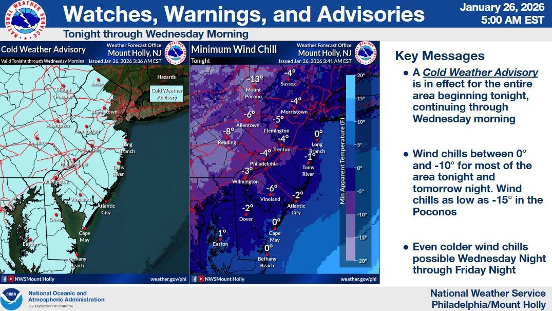
While the precipitation ended for most of the region on Sunday, the area is not out of the woods. Temperatures will plummet to potentially historic lows over the coming days, with wind chills dropping to negative 10 in parts of the five-county area.
"Its quite rare to get a stretch of temperatures this cold for so long," the National Weather Service's Mt. Holly, New Jersey branch said in a statement.
A Cold Weather Advisory is in place from 7 p.m. Monday through 10 a.m. Wednesday.
The cold will freeze snow and any moisture on the roads, potentially creating hazardous travel conditions.
It will also make being outside at all dangerous for many. Near-negative wind chills are expected every night of the week this week in the Philly area, ranging from 3 degrees Monday night falling to negative 14 by Thursday night.
Here's the full forecast for the coming days:
Monday
Mostly cloudy, with a high near 28. West wind 10 to 15 mph.
Monday Night
Mostly clear, with a low around 8. Wind chill values as low as -4. West wind 10 to 15 mph, with gusts as high as 25 mph.
Tuesday
Sunny, with a high near 22. Wind chill values as low as -4. West wind around 10 mph, with gusts as high as 20 mph.
Tuesday Night
Mostly clear, with a low around 7. Wind chill values as low as -2. West wind around 5 mph.
Wednesday
Mostly sunny, with a high near 20. West wind 5 to 10 mph.
Wednesday Night
Partly cloudy, with a low around 3.
Thursday
Sunny, with a high near 18.
Thursday Night
Mostly clear, with a low around 1.
Friday
Sunny, with a high near 15.
Friday Night
Mostly clear, with a low around 3.
Saturday
Sunny, with a high near 23.
Saturday Night
Mostly clear, with a low around 7.
Sunday
Mostly sunny, with a high near 26.
Get more local news delivered straight to your inbox. Sign up for free Patch newsletters and alerts.