Weather
Storm To Hit Eastern PA With Heavy Rain, Gusty Winds: See Timing
A powerful storm emerging from the south will bring "beneficial" rain to the region in the midst of dry conditions, forecasters said.

A powerful weather front will deliver potentially significant rain and wind to the greater Philadelphia over the coming days, forecasters said.
The storm will arrive after 2 p.m. Tuesday afternoon and continue overnight into late Wednesday, the National Weather Service said. Anywhere from a quarter of an inch to half an inch of rain could fall in the five county area in southeastern Pennsylvania, while greater amounts are likely south and east of the I-95 corridor.
"We'll see some beneficial rainfall across at least parts of the area over the next day or two due to a coastal low to our south," the National Weather Service's Mt. Holly, New Jersey branch said in a statement Tuesday. "The heaviest amounts will be near the coast with amounts tapering off as you head northward."
Find out what's happening in Across Pennsylvaniafor free with the latest updates from Patch.
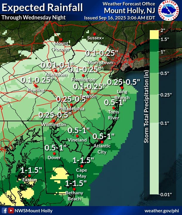
Accuweather notes that the exact total of rain "will be dependent on the track of the storm and how much dry air remains in the region."
Thunderstorms are also possible on Wednesday, forecasters note.
Find out what's happening in Across Pennsylvaniafor free with the latest updates from Patch.
The estimated rainfall totals may appear paltry compared to some of the massive summer deluges, but it comes in the midst of a relatively dry period heading into the start of autumn. While none of eastern Pennsylvania is experiencing drought, according to the U.S. Drought Monitor, there are portions of Montgomery, Delaware, and Bucks counties, but mostly Chester County, that are currently considered "abnormally dry," and this storm is likely to alleviate those conditions, officials said.
The storm system, which is emerging from the south, is likely to be more severe in coastal communities in the Carolinas, Virginia, and Maryland, with up to 4 to 8 inches of rain predicted, forecasters said.
Here's the full forecast for the rest of the week, according to the National Weather Service:
TuesdayA chance of showers, mainly after 2 p.m. Mostly cloudy, with a high near 75. East wind around 10 mph, with gusts as high as 20 mph. Chance of precipitation is 30 percent. New precipitation amounts of less than a tenth of an inch possible.
Tuesday night
A chance of showers and thunderstorms, mainly after midnight. Mostly cloudy, with a low around 62. Northeast wind around 10 mph. Chance of precipitation is 50 percent. New rainfall amounts of less than a tenth of an inch, except higher amounts possible in thunderstorms.
Wednesday
Showers likely and possibly a thunderstorm. Cloudy, with a high near 71. Northeast wind around 10 miles per hour. Chance of precipitation is 70 percent. New rainfall amounts between a tenth and quarter of an inch, except higher amounts possible in thunderstorms.
Wednesday Night
Showers likely, mainly before 2 a.m. Mostly cloudy, with a low around 64. Northeast wind 5 to 10 miles per hour. Chance of precipitation is 60 percent. New precipitation amounts of less than a tenth of an inch possible.
Thursday
A chance of showers, mainly before 2 p.m. Partly sunny, with a high near 80. North wind around 5 miles per hour. Chance of precipitation is 30 percent. New precipitation amounts of less than a tenth of an inch possible.
Thursday Night
Mostly clear, with a low around 63.
Friday
Sunny, with a high near 85.
Friday Night
Mostly clear, with a low around 60.
Get more local news delivered straight to your inbox. Sign up for free Patch newsletters and alerts.


