Weather
Tropical Storm Debby Remnants To Hit Philly Area, Tornadoes Possible
Heavy rain, thunderstorms, flooding, and wind damage are all likely, forecasters said. See timing, more details:

PHILADELPHIA, PA — The remnants of Tropical Storm Debby will sweep through the greater Philadelphia area on Friday, bringing torrential rain, flooding, and the possibility of severe winds and tornadoes, forecasters said.
The storm, which has dumped more than a foot of rain on parts of the south and which was moving across South Carolina as of Thursday morning, will arrive in the Delaware Valley region on Friday.
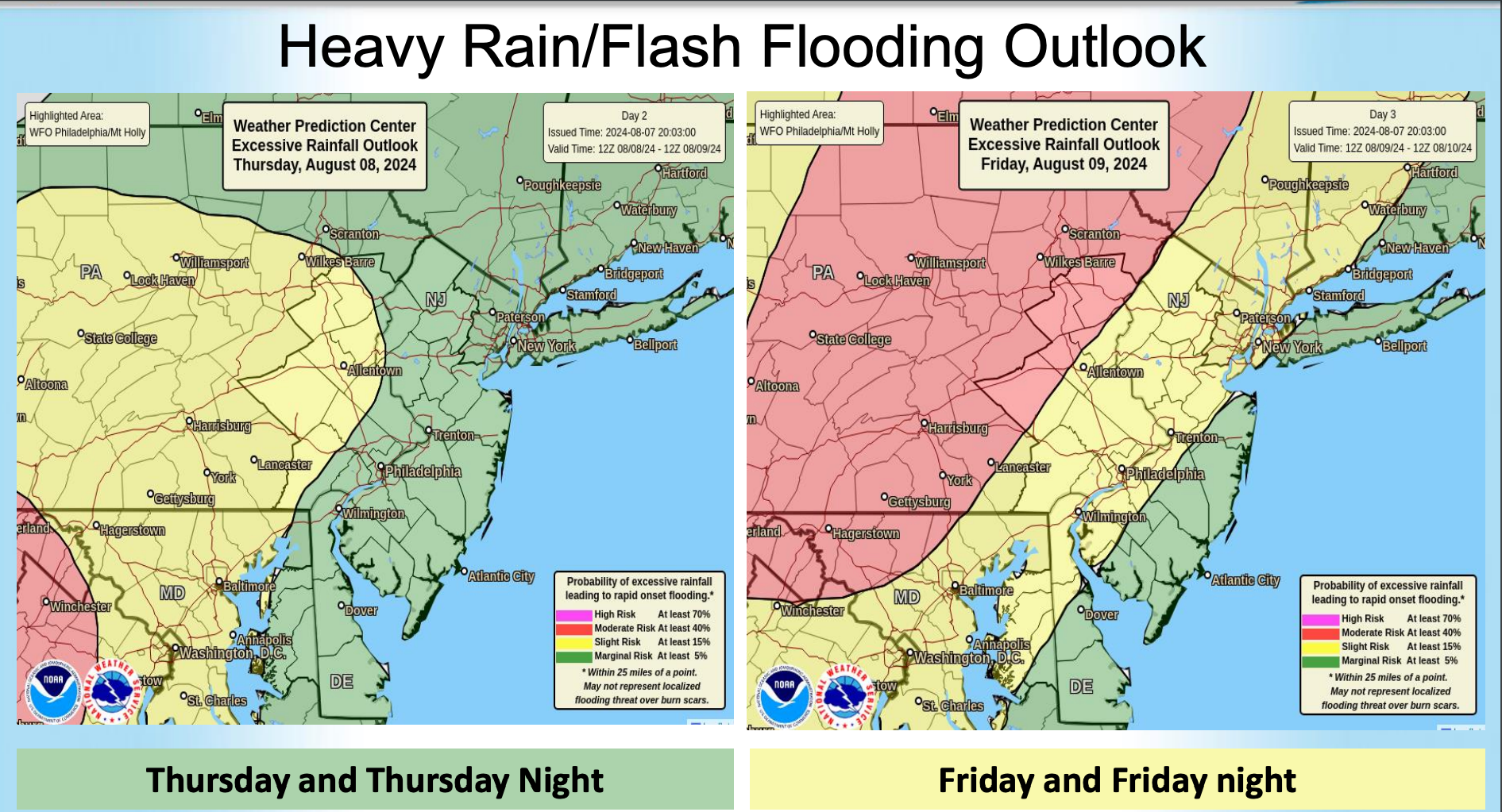
Some scattered thunderstorms and rain are possible in the area on Thursday, and Debby will merge with a different front as it moves into the Philadelphia area by around 2 a.m. Friday.
Find out what's happening in Across Pennsylvaniafor free with the latest updates from Patch.
The severity of the storms will depend on exactly where the front moves, forecasters said.
Heavy storms will continue until through the night Friday and into early Saturday morning. Rainfall could be severe at times where thunderstorms hit, leading to flash flooding.
Find out what's happening in Across Pennsylvaniafor free with the latest updates from Patch.
Winds of 20 miles per hour are expected, and extensive wind damage and power outages are possible.
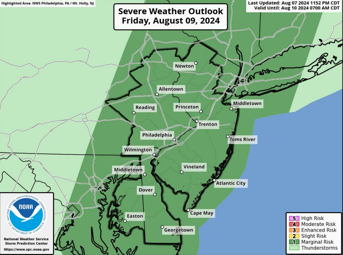
Potential tornadoes represent "the greatest threat" from the storm, forecasters said, with a one in six chance of one forming in the area, likely at some point during the day on Friday.
"The magnitude of the impacts locally later tonight and especially Friday into Friday night
will depend on the exact track, however a more inland track is currently expected," the National Weather Service's Mt. Holly, New Jersey branch said in a statement.
Impacts will be widespread across the region, but the areas to the north and to the west of I-95 are most at risk.
Here's the full forecast:
Thursday
Scattered showers and thunderstorms, then showers likely and possibly a thunderstorm after 11 a.m. Mostly cloudy, with a high near 77. East wind around 10 mph. Chance of precipitation is 60 percent. New rainfall amounts between a tenth and quarter of an inch, except higher amounts possible in thunderstorms.
Thursday Night
Scattered showers and thunderstorms, then showers likely and possibly a thunderstorm after 3 a.m. Mostly cloudy, with a low around 73. Southeast wind 5 to 10 mph. Chance of precipitation is 60%. New rainfall amounts between a tenth and quarter of an inch, except higher amounts possible in thunderstorms.
Friday
Showers and possibly a thunderstorm. Some of the storms could produce heavy rainfall. High near 82. Breezy, with a south wind 15 to 20 mph, with gusts as high as 30 mph. Chance of precipitation is 90 percent. New rainfall amounts between a half and three quarters of an inch possible.
Friday Night
Showers and possibly a thunderstorm before 2 a.m, then a chance of showers and thunderstorms after 2 a.m. Low around 73. South wind around 15 mph, with gusts as high as 25 mph. Chance of precipitation is 80 percent. New rainfall amounts between a quarter and half of an inch possible.
Saturday
A chance of showers before 8 a.m. Sunny, with a high near 83. West wind around 10 mph. Chance of precipitation is 30 percent. New precipitation amounts of less than a tenth of an inch possible.
Saturday Night
Mostly clear, with a low around 64.
Sunday
Sunny, with a high near 82.
Sunday Night
Mostly clear, with a low around 64.
Get more local news delivered straight to your inbox. Sign up for free Patch newsletters and alerts.


