Weather
Slow-Moving Ophelia Bringing More Rain, Gusty Winds To Southeast PA: Latest
The Philadelphia area will be under a coastal flood advisory Saturday after Ophelia made landfall and continued to push north.


This story was last updated at 11:59 p.m. Saturday.
PHILADELPHIA, PA — The storm Ophelia, which weakened into a post-tropical cyclone Saturday, will keep rain and gusting winds in the forecast for part of Pennsylvania into Sunday as it continues north.
"Ophelia will continue to bring widespread rain and minor coastal flooding to our region through Sunday night, said the National Weather Service. "Ophelia will weaken to a remnant area of low pressure while tracking across our region, before departing on Monday."
Find out what's happening in Across Pennsylvaniafor free with the latest updates from Patch.
As of 11 p.m. Saturday, Post-Tropical Cyclone Ophelia was moving over Washington, D.C. with maximum sustained winds of 35 miles per hour, and was going north at 8 mph. The center of Ophelia is expected to turn toward the north-northeast and the northeast, weakening further while it tracks across eastern Pennsylvania and departing on Monday, said the National Hurricane Center.
Southeastern Pennsylvania was already feeling the effects of Ophelia on Saturday as rain and wind gusts up to 30 mph pounded the region. A flood advisory along the Delaware River was in effect from 7 p.m. until midnight Saturday for Philadelphia, as well as Delaware and Lower Bucks counties.
Find out what's happening in Across Pennsylvaniafor free with the latest updates from Patch.
Residents living in coastal areas are at the greatest risk for storm impacts, forecasters said. According to the National Weather Service, minor and spotty coastal flooding is expected for much of the Philadelphia area.
The storm will bring heavy showers overnight Saturday, and more rain with low clouds as it moves north. Forecasters said that wind gusts of 25 to 35 miles per hour will persist through Sunday night, but no counties are under a high wind warning as of 11 p.m. Saturday.
Overall rain totals for this storm are expected to be around 2 to 4 inches, with higher isolated totals.
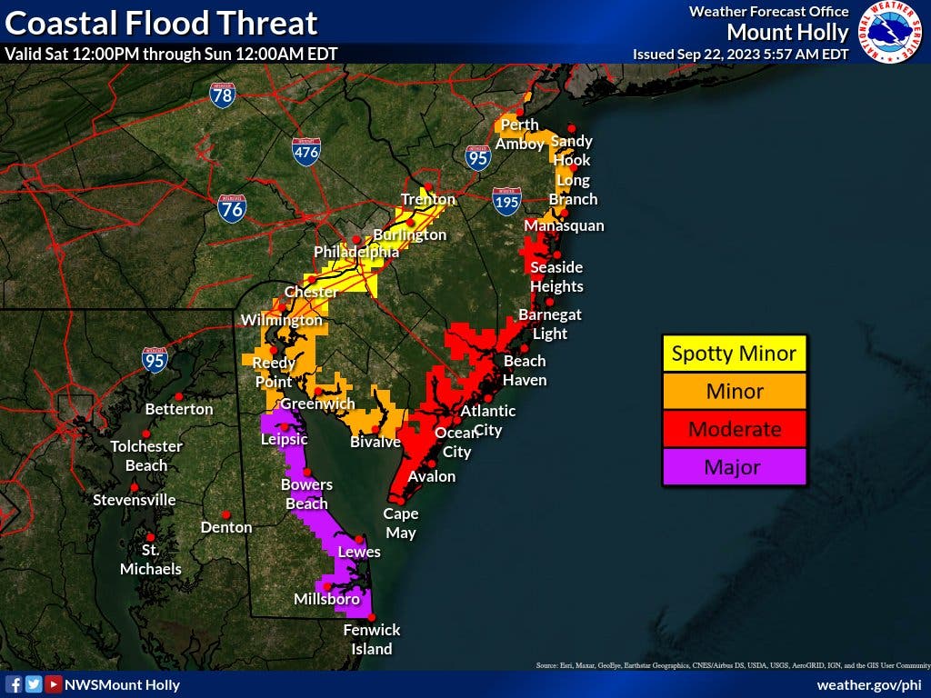
Click here to view all the current watches and warnings for Pennsylvania from the National Weather Service. View the NWS graphic below to see potential hazards, impacts, and timing for the storm this weekend:

Ophelia came ashore with near-hurricane-strength winds of 70 mph around 6:15 a.m. and was expected to weaken as it turns north Saturday and then shifts northeast on Sunday, the U.S. National Hurricane Center said.
At 11 a.m., Ophelia was located about 75 miles northwest of Cape Lookout, North Carolina, and was packing maximum sustained winds of 50 mph. The storm was moving north at 13 mph, according to the National Hurricane Center.
Wind gusts were recorded as high as 72 mph at Cape Lookout on Saturday morning. More than 80,000 customers had lost power as of 8 a.m., according to PowerOutage.us, with about one-half of that number in North Carolina.
Here is the National Weather Service forecast for the Philadelphia area through Sunday:
Saturday: Periods of rain. High near 64. Breezy with a northeast wind 20 to 25 mph and gusts as high as 40 mph.
Saturday Night: Periods of rain. Low around 60. Breezy with a northeast wind 15 to 20 mph and gusts as high as 35 mph.
Sunday: Showers and possibly a thunderstorm. High near 68. East wind around 15 mph.
Sunday Night: Showers likely, mainly before 2 a.m. Cloudy with a low around 60. Northeast wind around 10 mph.
Get more local news delivered straight to your inbox. Sign up for free Patch newsletters and alerts.