Weather
What 5 Meteorologists Are Saying About Winter Storm Targeting PA
The consensus is clear: a big winter storm is likely this weekend. But timing and accumulation is unclear. Here's what 5 experts are saying:

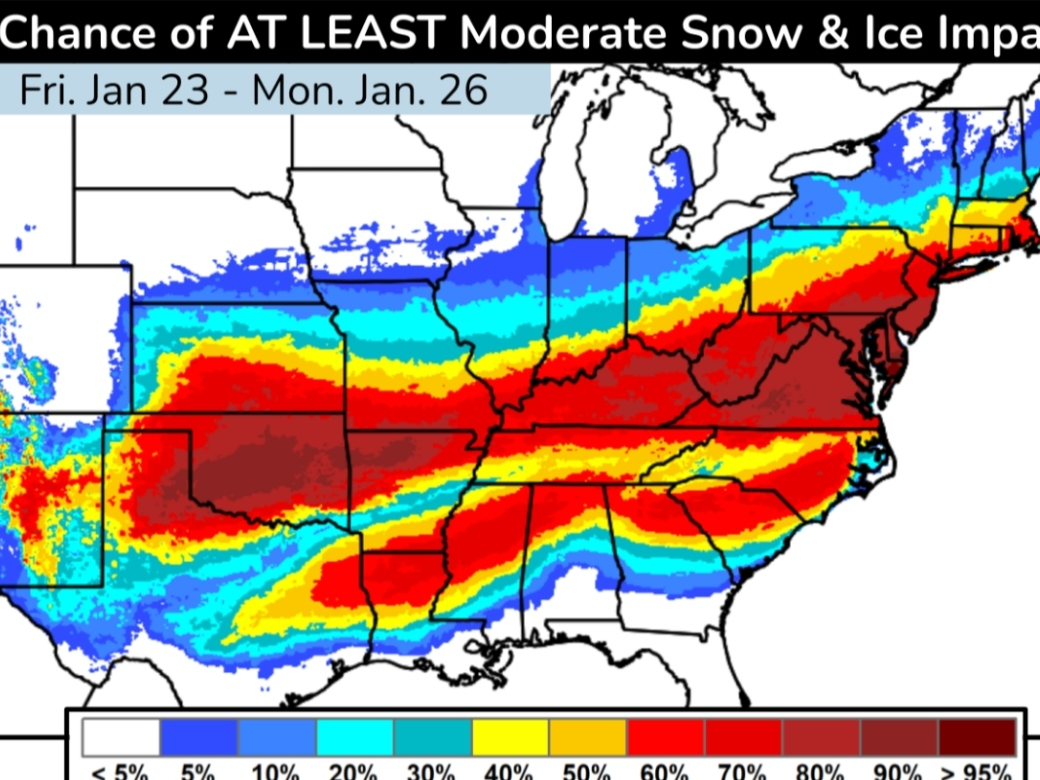
Forecasters continue to monitor what many are classifying as a potential "major" snow event that's expected to arrive in the greater Philadelphia area this weekend. The National Weather Service is currently estimating an up to 90 percent chance for at least six inches of snow in parts of the region — but there is the chance we could get more.
"The potential for a significant storm to impact the area this weekend continues to increase," the National Weather Service's Mt. Holly, New Jersey branch shared in a statement Wednesday morning.
The agency further clarified in a post Wednesday afternoon that, while it's clear there will be a winter storm with regional impacts as early as Saturday night, they are not making full snow and ice accumulation predictions until Friday. The location that is targeted to receive the highest snowfall as well as the exact timing of the precipitation is yet to be determined, the agency said.
Find out what's happening in Across Pennsylvaniafor free with the latest updates from Patch.
"What you should do now: Prepare for snow over the weekend & prolonged cold next week. Travel impacts are likely; consider adjusting weekend plans accordingly," the National Weather Service out of Mt. Holly said Wednesday afternoon.
Across the region, meteorologists agree the Philadelphia area could be in for a doozy of a storm, but most are cautioning it's still premature to make specific predictions on the scope of the impacts and the locations that could bear the worst of the weather event.
Find out what's happening in Across Pennsylvaniafor free with the latest updates from Patch.
For now, here's what five meteorologists are saying as of Wednesday afternoon about the weekend storm:
'The biggest storm in the last SEVERAL years'
Jordan Steele, a meteorologist with The Weather Channel, classified the storm as having the potential of being the biggest in years. "A lot can change depending on the placement of the HIGH. But this will be the biggest winter storm of the season. And for some of us -- the biggest storm in the last SEVERAL years," he said in a tweet.
Steele cautioned people in the storm's path to "plan for going day(s) without power this weekend. School cancellations next week." He further recommended: "Do not plan a road trip this weekend. This could be a situation where people get stuck on the highway."
A lot can change depending on the placement of the HIGH. But this will be the biggest winter storm of the season. And for some of us -- the biggest storm in the last SEVERAL years. https://t.co/Iv81recTaA
— Jordan Steele (@JordanSteele) January 20, 2026
Early prediction for big snowfall
In an early snowfall prediction, FOX29 meteorologist Drew Anderson said as of Wednesday afternoon models are showing the Philadelphia region could see as much as a foot of snow. "If the models stay high for the next day, then get the snow thrower ready," said Anderson.
'Huge winter storm'
Charles Peek of The Weather Channel said while the specifics remain unclear, people should understand this will be a "huge winter storm" for much of midwest and east coast.
"Please understand this forecast will likely change again and for who gets what and how much but understand this will be a huge winter storm and if you live in these areas prepare now. Be prepared for extended power outages for those that get the ice."
Update 01/21/2026 AM forecast for Winter Storm Fern. This is the forecast at this point and it shifted north some.
Please understand this forecast will likely change again and for who gets what and how much but understand this will be a huge winter storm and if you live in… pic.twitter.com/kf0pf4jScK
— Charles Peek (@CharlesPeekWX) January 21, 2026
'MAJOR IMPACT EVENT'
The Weather Channel's most famous face, Jim Cantore, said via X that the storm will be a "MAJOR IMPACT EVENT from Southern Plains to the East Coast regardless of track shift."
He highlighted the particular risk of ice to areas of the south. "It's not out of the realm of possibility that many of you in this "CRIPPLING" area see ICE ACCRETION over 1".
It's not out of the realm of possibility that many of you in this "CRIPPLING" area see ICE ACCRETION over 1".
In a storm like this, FREEZING RAIN of that magnitude is a disaster. This could be where some of the biggest impacts lie simply because of extended power loss with very… pic.twitter.com/JFdD5MZXDS
— Jim Cantore (@JimCantore) January 21, 2026
'Significant snow and ICE concerns'
Alex Wallace of The Weather Channel also cautioned that, while there will be adjustments to the forecast as the storm approaches, "there are significant snow and ICE concerns."
Residents in the path of the storm should be prepared for power outages and difficult travel for "days."
Not liking what I'm seeing! There are sure to be changes on exactly where things will set up BUT there are significant Snow and ICE concerns! For the areas in the higher ice totals, please be prepared for power outages & impossible travel for days! pic.twitter.com/CzfD5G2Yo3
— Alex Wallace (@TWCAlexWallace) January 21, 2026
Get more local news delivered straight to your inbox. Sign up for free Patch newsletters and alerts.