Weather
When To Expect The Worst Of The Nor'easter In Philly Region This Weekend
Forecasters now have a clearer picture of the nor'easter's track up the Atlantic.


The approaching nor'easter will bring powerful winds and continuous rain to the greater Philadelphia area through at least Saturday night, with more possible on Sunday, according to the latest forecast.
The National Weather Service is now confident in at least the track of the storm through Saturday night. It currently is powerful enough to bring intermittent but ongoing rain from late Friday through Saturday evening.
Potentially destructive winds will be one of the greatest impacts. Sustained winds of 15 to 25 miles per hour, with gusts up to 45 miles per hour in some areas, are expected. A wind advisory has been issued from 6 p.m. Friday to 6 a.m. Sunday.
Find out what's happening in Across Pennsylvaniafor free with the latest updates from Patch.
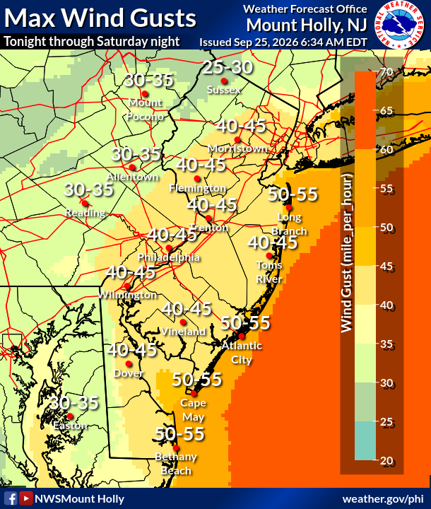
"Gusty winds will blow around unsecured objects," the National Weather Service said. "Tree limbs could be blown down and a few power outages may result."
Up to a quarter inch of rain could fall Friday night, with between a half and three quarter inches Saturday, and another half inch Saturday night.
Find out what's happening in Across Pennsylvaniafor free with the latest updates from Patch.
"It won't be raining constantly, but periods of rain are expected to continue through Sunday," the agency added.
Still, in the Philadelphia area, no significant fresh water flooding is expected. The only risk of flooding remains tidal flooding of the Delaware River.
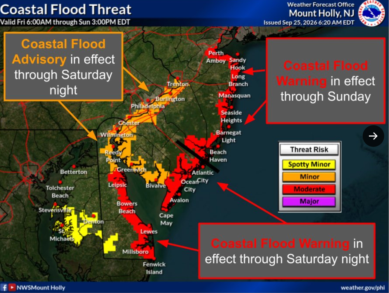
The Coastal Flood Advisory for parts of Philadelphia, Delaware, and Bucks counties remains in place until 5 a.m. Sunday.
While the strongest impacts of the storm are expected to hit by late Saturday, there is still some variability in the forecast depending on the final tracking of the storm.
"By Sunday, the forecast is much more uncertain and will depend on the track of a low developing off the coast," the National Weather Service said.
Here's the full forecast for the coming week:
Friday
Mostly cloudy, with a high near 73. Breezy, with a north wind 15 to 20 mph.
Friday Night
A chance of rain, mainly after 1 a.m. Mostly cloudy, with a low around 58. Breezy, with a north wind 15 to 20 mph. Chance of precipitation is 30 percent. New precipitation amounts between a tenth and quarter of an inch possible.
Saturday
Rain. High near 63. Breezy, with a north wind around 20 mph, with gusts as high as 40 mph. Chance of precipitation is 90 percent. New precipitation amounts between a half and three quarters of an inch possible.
Saturday Night
Rain. Low around 57. Breezy, with a north wind 15 to 20 mph, with gusts as high as 40 mph. Chance of precipitation is 80 percent. New precipitation amounts between a quarter and half of an inch possible.
Sunday
Rain. High near 65. North wind around 15 mph, with gusts as high as 30 mph. Chance of precipitation is 80 percent. New precipitation amounts between a half and three quarters of an inch possible.
Sunday Night
Rain, mainly before 8 p.m. Low around 59. Chance of precipitation is 80 percent. New precipitation amounts of less than a tenth of an inch possible.
Monday
Mostly cloudy, with a high near 70.
Monday Night
Mostly cloudy, with a low around 59.
Tuesday
Partly sunny, with a high near 74.
Tuesday Night
Partly cloudy, with a low around 59.
Wednesday
Mostly sunny, with a high near 77.
Wednesday Night
Mostly cloudy, with a low around 61.
Thursday
Mostly sunny, with a high near 80.
Get more local news delivered straight to your inbox. Sign up for free Patch newsletters and alerts.