Last week's forecast blew up in many a forecaster's face, including my own. A slow moving warm front moved even more slowly than anticipated, resulting in a couple of days of clouds and a dreary middle of the week. The warm front finally cleared, but after thunderstorms along a cool front slid south through the region on Friday night, another round of clouds from the Atlantic took over. Frontal boundaries slow as they try to slip south of our latitude at this time of the year, thanks to the developing subtropical high pressure ridge of the Southeast. That ridge prevents colder air from sinking too far south, and as longer days continue to weaken influence of colder air masses with each passing day, the pattern can stagnate. Many times, it stagnates over us.
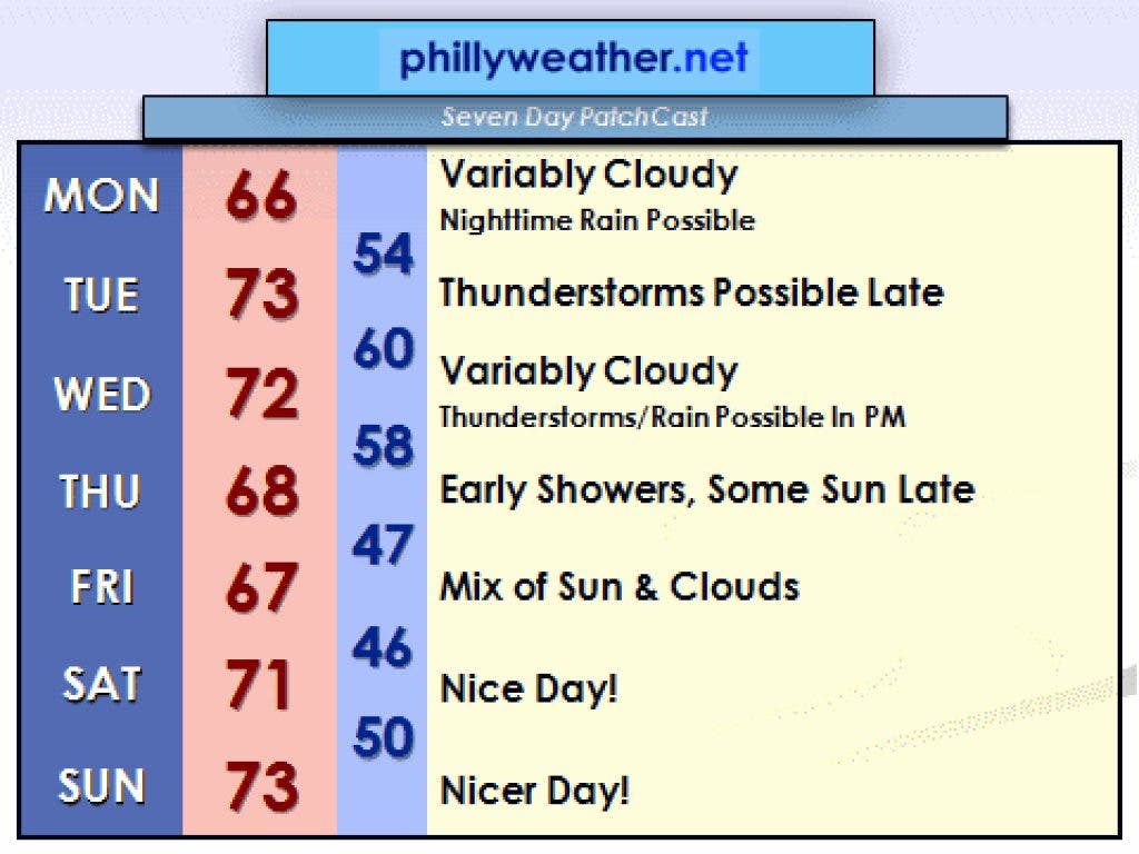
Another round of this type of weather is a part of our forecast through Thursday, though a nice weekend is likely. Another slow moving frontal boundary will march east through the Great Lakes and to the East Coast on Tuesday, Wednesday, and Thursday. The front will be to our west on Tuesday, bringing a chance for thunderstorms late in the day and at night. It will be overhead on Wednesday to bring a chance of showers or storms, and then finally off the coast on Thursday. When it reaches the coast, low pressure may organize along the front and move northeast. This could throw some additional rainfall back into the region on Wednesday night and Thursday morning. It won't rain the whole time between Tuesday and Thursday, but it's not going to be universally nice throughout midweek.
Despite the murky pattern of late, rainfall is still needed and appreciated. Deficits on rainfall since January 1st average in the four to five inch range across the region, and the area has seen below average rainfall each month this year so far. Provided the rains aren't of the ark-busting variety, we can use it.
Find out what's happening in Lower Gwynedd-Ambler-Whitpainfor free with the latest updates from Patch.
The good news? Next weekend looks awfully nice. High temperatures look to be in the 70's on both Saturday and Sunday. It might end up being the nicest weekend we've seen around here in about a month. If we can get through Thursday without quacking too much about the weather, we will get to enjoy one fine weather weekend.
-------------------------------------------------------------------------------
Find out what's happening in Lower Gwynedd-Ambler-Whitpainfor free with the latest updates from Patch.
Tom Thunstrom is the editor and publisher of Phillyweather.net. You can follow the site on twitter at @phillywx or on Facebook.