Community Corner
Nor'easter: Flooding, Rain, Snow Heavy Enough To 'Bring Down' Power Lines
A coastal flood watch will take effect Tuesday morning, and last through Tuesday afternoon as the storm hits Pennsylvania.


By Tom Davis
A nor’easter packed with gale-force winds will hit Pennsylvania early Tuesday, dumping enough heavy rain and wet snow to produce power outages and flooding, forecasters say.
The significant storm will slowly churn up the coast, dumping rain and wet snow that will be ”heavy enough to bring down the trees and power lines,” said Ari Sarsalari, a meteorologist on The Weather Channel.
Find out what's happening in Lower Providencefor free with the latest updates from Patch.
A coastal flood watch will take effect Tuesday morning, and last through Tuesday afternoon, according to the National Weather Service’s Mount Holly office.
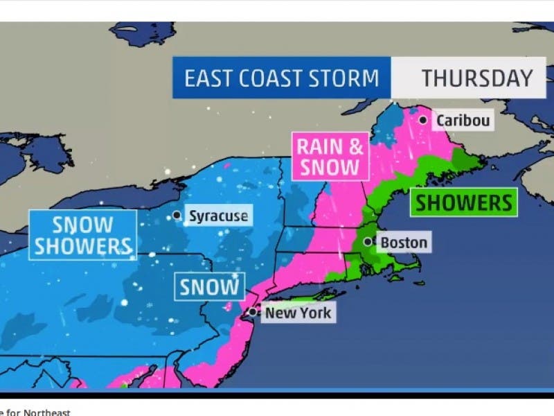
The storm is expected to last until Thursday, producing snow in the northwestern and southwestern portions of New Jersey, and a snow-and-rain mix for the coastal and northeastern portions (see picture from The Weather Channel).
Find out what's happening in Lower Providencefor free with the latest updates from Patch.
Enough snow and rain will fall to overload drains and flood Jersey Shore streets, and impact roads that run near rivers and lakes throughout eastern Pennsylvania, according to the National Weather Service.
According to the NWS:
- Snowfall amounts of 6 inches or greater are possible through Tuesday night in the Poconos, in addition to some light icing. Lesser amounts are forecast for northwestern New Jersey.
- Rainfall of greater than 2 inches are possible. Some of the rain could be locally heavy, especially on Tuesday, which could cause flooding of small streams, in urban areas and on road surfaces.
- Northeasterly winds are forecast to increase to 10 to 20 mph on Tuesday with gusts to 25 or 30 mph possible, especially closer to the coast. Depending on the track of the storm, the wind could be stronger.
- Gale-force wind gusts are possible on the coastal waters of New Jersey and Delaware from Monday night into Tuesday. Storm conditions are possible, especially north, ultimately depending on the track and strength of the storm.
- Moderate tidal flooding is likely Monday and possibly again Tuesday on the Atlantic Ocean and Delaware Bay.
- Wind-driven heavy rains and wave action will exacerbate the potential for beach erosion Tuesday. Tidal flooding could cause some road closures, according to the National Weather Service. Expect road closures at high tide on Tuesday.
- At Sandy Hook, high tide will occur at 9:19 a.m. Tuesday with a forecast tide level of 7.5 to 8 feet above mean. At Seaside Heights, high tide will occur at 8:49 a.m. with a forecast tide level near 7 feet above mean.
- The seas are expected to be 8 to 12 feet Monday on the Atlantic Ocean, increasing to 10 to 15 feet on Tuesday.
Get more local news delivered straight to your inbox. Sign up for free Patch newsletters and alerts.