Community Corner
Showers Exit as Breezy Conditions Develop
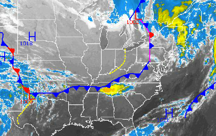
A cold front will keep showers a threat Wednesday followed by breezy and cooler conditions.

By Steven DiMartino
Widely scattered showers will linger throughout the Philadelphia and New York City metropolitan areas through Wednesday afternoon as a cold front drives through the region. However, skies will clear by Wednesday evening with breezy conditions as a fresh Polar air mass builds in.
Widely scattered to isolated showers can be expected through Wednesday afternoon for the region, with otherwise broken to scattered cloud cover. Winds will veer from the south to the west at 10 to 20 mph with gusts over 30 mph at times. Temperatures will remain above normal with highs in the lower to mid 70s throughout the region.
Find out what's happening in Malvernfor free with the latest updates from Patch.
High pressure will build into the Philadelphia and New York City metropolitan areas Wednesday evening on through Thursday, with clear skies to scattered cloud cover. Winds will be from the west and northwest at 5 to 15 mph. Low temperatures will range from the lower to mid 40s over the interior and upper 40s to lower 50s along the coast. High temperatures will range from the lower to mid 60s over the interior and upper 60s to lower 70s along the coast.
A cold front will drop through the northern Mid Atlantic on Friday, with increasing clouds and showers developing by the afternoon. The showers will increase in coverage on Friday night into Saturday with some heavy downpours at times. Winds will veer to the northeast at 5 to 15 mph through the period. Low temperatures will range from the upper 30s to lower 40s over the northern interior and mid to upper 40s along the coast. High temperatures will range from the lower to mid 60’s throughout the northern Mid-Atlantic.
Find out what's happening in Malvernfor free with the latest updates from Patch.
Scattered showers will linger Saturday night on through Monday with a few heavy downpours possible as waves of low pressure pass to the south. Otherwise, scattered to overcast clouds can be expected. Temperatures will average near to slightly below normal. Low temperatures will range from the lower to mid 40s over the northern interior and mid to upper 40s along the coast. High temperatures will range from the lower to mid 60s over the interior and mid to upper 60s along the coast.
The cold front will lift north as a warm front on Monday night with additional showers followed by clearing skies on Tuesday as the warm front lifts into New England. Temperatures will briefly return to above normal levels with lows in the mid to upper 50s and highs in the lower to mid 70s.
Get more local news delivered straight to your inbox. Sign up for free Patch newsletters and alerts.