Community Corner
Sorry, Malvern: Warm Conditions Won't Last Long
Don't get used to these mild temperatures, because winter is coming and you'll feel it this weekend.

By Steven DiMartino
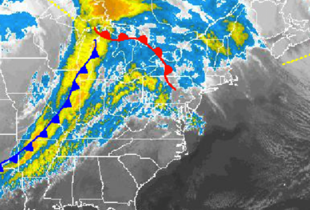
A warm front lifting north into New England Tuesday morning will drive a very mild air mass into the Philadelphia area, leading to temperatures ending up well above normal for this time of year. However, don’t get used to these early summer-like temperatures, because winter is coming and you’ll feel it this weekend.
Clouds will slowly increase through Wednesday morning as winds develop from the southwest at 5 to 15 mph. Winds will increase from the southwest at 10 to 20 mph by Wednesday morning. Temperatures will be well above normal through Wednesday morning. Temperatures Wednesday morning will range from the lower to mid 50s throughout the region.
Find out what's happening in Malvernfor free with the latest updates from Patch.
A cold front will drive through the Philadelphia area Wednesday afternoon, leading to showers late Wednesday morning on through the evening. These showers will be capable of producing heavy downpours and wind gusts over 30 mph. An isolated thunderstorm is possible with heavy downpours, occasional lightning, and wind gusts over 40 mph. Winds will veer from the southwest to northwest at 10 to 20 mph. Temperatures Wednesday afternoon will rise into the mid 60s throughout the Philadelphia and New York City metropolitan areas.
Skies will clear for Thursday with high pressure locked in over New England. Winds will veer to the north at 5 to 15 mph. Temperatures will return to seasonable levels. Low temperatures will range from the upper 30s to lower 40s over the interior and lower to mid 40s along the coast. High temperatures will range from the mid to upper 50s over the interior and upper 50s to lower 60s along the coast.
Find out what's happening in Malvernfor free with the latest updates from Patch.
A coastal low-pressure system will develop off the southern New Jersey coast on Friday evening, with increasing clouds through the day and showers developing in the evening. The low-pressure system will intensify on Saturday morning with periods of rain along the coast and a rain/snow mix over the interior. No snowfall accumulation is expected at this time. The low-pressure system will exit by Saturday evening with clearing skies yet very windy conditions. Low temperatures on Friday will range from the lower to mid 30s. High temperatures on Friday will range from the mid to upper 50s throughout the region. Low temperatures on Saturday will range from the lower to mid 30s. High temperatures will on Saturday will range from the upper 40s to lower 50s throughout the region.
Clearing skies are expected on Sunday and Monday with very chilly weather conditions. A strong northwesterly wind will be in place leading to rather chilly wind chills on Sunday. Low temperatures will range from the mid to upper 20s. High temperatures will range from the mid to upper 40s over the interior.
Get more local news delivered straight to your inbox. Sign up for free Patch newsletters and alerts.