Community Corner
Thanksgiving Holiday Forecast: Snow Coming To Lehigh Valley
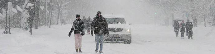
Near-record temperatures Monday and the potential for snow on Wednesday in the Lehigh Valley.

The National Weather Service issued a hazardous weather outlook for Wednesday and the Thanksgiving Holiday.
“Accumulating snow is possible Wednesday through Thanksgiving morning. From the Interstate 95 corridor to the Interstate 80 corridor, at this time snow amounts are expected to range from 2 to 6 inches,” the National Weather Service said in the hazardous weather outlook. “If you have travel plans for Wednesday, please stay tuned to the latest forecast for more details as we draw closer to Wednesday.”
According to the National Weather Service, the Lehigh Valley should expect snow during the Thanksgiving Holiday. The Eastern Pennsylvania Weather Authority (EPWA) reports a storm system in the Carolinas will be moving north and will develop rapidly, bringing heavy snow and a mix of rain and snow further southeast. This storm presents the threat of the first major snowfall of the season on Wednesday and Wednesday night, according to the EPWA.
Find out what's happening in Nazarethfor free with the latest updates from Patch.
The current forecast for Wednesday from the National Weather Service is:
Wednesday: Rain and snow likely before 1pm, then snow between 1pm and 4pm, then rain and snow after 4pm. High near 40. North wind 5 to 9 mph. Chance of precipitation is 80%. New snow accumulation of 1 to 3 inches possible.
Find out what's happening in Nazarethfor free with the latest updates from Patch.
Wednesday Night Snow before 1am, then a chance of rain and snow between 1am and 2am, then a chance of snow after 2am. Low around 30. Chance of precipitation is 80%. New precipitation amounts between a tenth and quarter of an inch possible.
Get more local news delivered straight to your inbox. Sign up for free Patch newsletters and alerts.