Weather
Winter Weather Advisory Issued Across Eastern PA
A winter weather advisory has been issued across Eastern Pennsylvania. Here's the latest:


EASTERN PA — A winter weather advisory has been issued across Eastern Pennsylvania ahead of a major winter storm that has impacted much of the nation. The storm is expected to bring snow, ice, freezing rain and wind to the region. The winter weather advisory is in place in the following areas from 5 a.m. Thursday through noon:
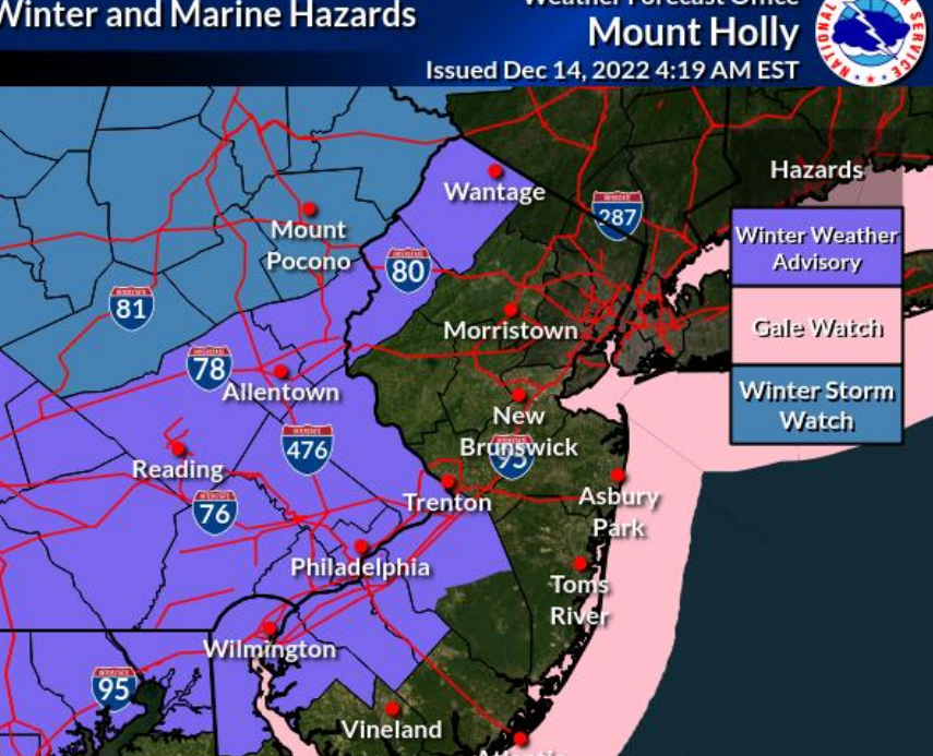
A winter storm watch is in place for much of central and western Pennsylvania extending into the Poconos in the north.
While the front is still set to hit the region, and much of Pennsylvania will indeed get some snow, it's very unlikely any will stick beyond a dusting in the Philadelphia area. Only the Poconos and some parts of Berks County are likely to get that level of snow, the National Weather Service said.
Find out what's happening in Norristownfor free with the latest updates from Patch.
Heavy rain remains the dominant form of precipitation expected.

Find out what's happening in Norristownfor free with the latest updates from Patch.
Snow is expected to begin early Thursday, before transitioning to rain and freezing rain in the late morning and early afternoon. "Little to no" ice and snow accumulation is currently predicted in the five-county Philadelphia area, but there's a higher chance in the suburbs and, of course, north into the Poconos.
Rain will continue overnight Thursday through Friday morning. Flooding is possible in many areas.
"The heavy rainfall, when combined with gusty winds, will lead to urban flooding and poor travel conditions," AccuWeather said. "Motorists are likely to encounter ponding and poor visibility, while airline delays will be possible due to visibility, wind and slick runways at the major hubs."
The National Weather Service warned about what the storm will do to the roads, particularly given that it is the first true snow event of the year. Conditions could be treacherous, and it's likely to back up traffic for some time.
"Precip will start to move in Thu AM," the agency's Mt. Holly, New Jersey branch said. "Though it is expected to change over to rain within a few hours for most, even a small amount of wintry mix can cause slippery road conditions. It's been several months since we had to drive in wintry conditions."
The massive system will impact nearly the entire country when all is said and done, having already brought heavy rains and wind to the California coast before dumping snow across the plains and midwest, forecasters said. The southern states are likely to see rain.
Here's the latest forecast:
Wednesday
Sunny, with a high near 41. Northwest wind around 10 mph.
Wednesday night
Mostly cloudy, with a low around 27. North wind around 5 mph becoming northeast after midnight.
Thursday
Snow likely, possibly mixed with rain, freezing rain, and sleet before 10am, then rain likely, possibly mixed with snow between 10am and 1pm, then rain after 1pm. High near 43. East wind 10 to 15 mph. Chance of precipitation is 100 percent. Little or no ice accumulation expected. Little or no snow and sleet accumulation expected.
Thursday night
Rain. Low around 43. Breezy, with an east wind 15 to 20 mph, with gusts as high as 35 mph. Chance of precipitation is 100 percent. New precipitation amounts between three quarters and one inch possible.
Friday
Rain likely, mainly before 1pm. Mostly cloudy, with a high near 47. Northeast wind around 15 mph becoming west in the afternoon. Winds could gust as high as 30 mph. Chance of precipitation is 60 percent. New precipitation amounts of less than a tenth of an inch possible.
Friday night
Partly cloudy, with a low around 33.
Get more local news delivered straight to your inbox. Sign up for free Patch newsletters and alerts.