Weather
2 Chances For Snow This Week In Eastern PA: Latest Forecast
There are two chances for snow this week, but it's still not clear if it'll be enough to end the near-historic snow drought.


PHILADELPHIA, PA — The latest round of storms heading to the greater Philadelphia area are likely to bring heavy rain and perhaps even a little snow, but it's still unclear if it'll be enough to end the near-historic snow drought in the region, according to the National Weather Service.
There are two chances for snow, with the first coming during the day Monday. Rain is likely throughout the day until 3 p.m., dropping up to a quarter of an inch, forecasters said. It's only in the low 40s, and it could get cold enough for snow in certain places.
"Rain may end as snow northwest of I-95 this morning," the National Weather Service's Mt. Holly, New Jersey branch said. "No road issues are expected, but higher elevations may see a coating."
Find out what's happening in Norristownfor free with the latest updates from Patch.
The bigger storm is likely to hit on Wednesday, and the biggest snow chance will be Wednesday morning.
"A brief dusting can't be ruled out into S NJ or N DE at onset," the National Weather Service added on Twitter. "Snow and any mixed wintry precip will eventually change to all rain by Wed afternoon or evening though, so any snow that does accumulate will likely melt away Wed night. We'll take what we can get at this point."
Find out what's happening in Norristownfor free with the latest updates from Patch.
At most, Philadelphia itself would see a dusting, and it would need to be more than a tenth of an inch in order to be considered "measurable" snowfall that would break the drought.
"Even with the back-to-back blows, experts say the ongoing snow drought may hold strong for at least part of the Interstate 95 corridor," AccuWeather added.
The storm will shift to rain by 2 p.m., but could become heavy again overnight as a thunderstorm potentially rolls through. Forecasters said up to two inches of rain could fall.
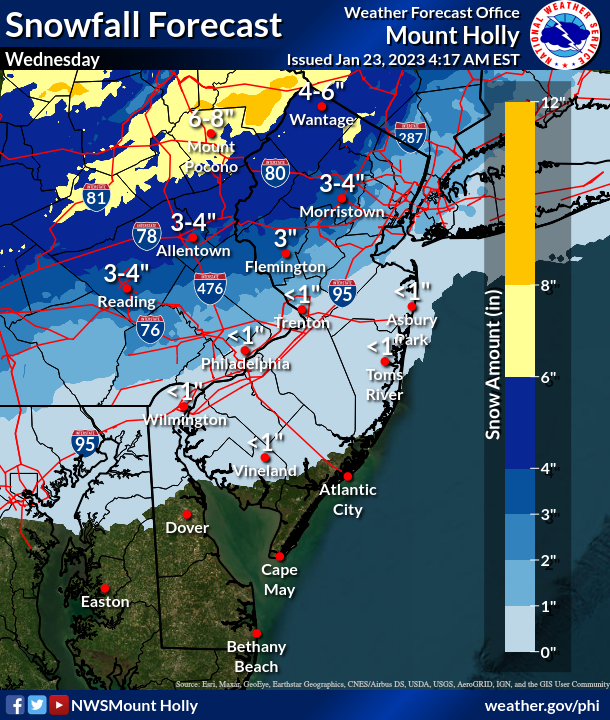
Here's the full forecast for the remainder of the week:
Monday
Rain likely, mainly before 3 p.m. Cloudy, with a high near 42. Northwest wind 10 to 15 mph, with gusts as high as 30 mph. Chance of precipitation is 70 percent. New precipitation amounts between a tenth and quarter of an inch possible.
Monday night
Mostly cloudy, then gradually becoming mostly clear, with a low around 31. Blustery, with a northwest wind 10 to 20 mph, with gusts as high as 30 mph.
Tuesday
Mostly sunny, with a high near 44. West wind around 15 mph, with gusts as high as 30 mph.
Tuesday night
Partly cloudy, with a low around 30. West wind 5 to 10 mph becoming light northwest after midnight.
Wednesday
Rain and snow likely between 8am and 2pm, then rain. High near 43. Light northeast wind becoming east 10 to 15 mph in the morning. Chance of precipitation is 80 percent. New snow accumulation of less than one inch possible.
Wednesday night
Rain and possibly a thunderstorm before 2 a.m., then a chance of rain. Some of the storms could produce heavy rainfall. Low around 43. Breezy. Chance of precipitation is 100 percent. New precipitation amounts between 1 and 2 inches possible.
Thursday
Partly sunny, with a high near 45. Breezy.
Thursday night
Mostly cloudy, with a low around 29. Breezy.
Get more local news delivered straight to your inbox. Sign up for free Patch newsletters and alerts.


