Weather
2 Winter Storms Headed For Philly Area: Latest Forecasts
Rain and sleet are predicted to hit the region twice this week, although one storm could still shift to bring snow, forecasters said.


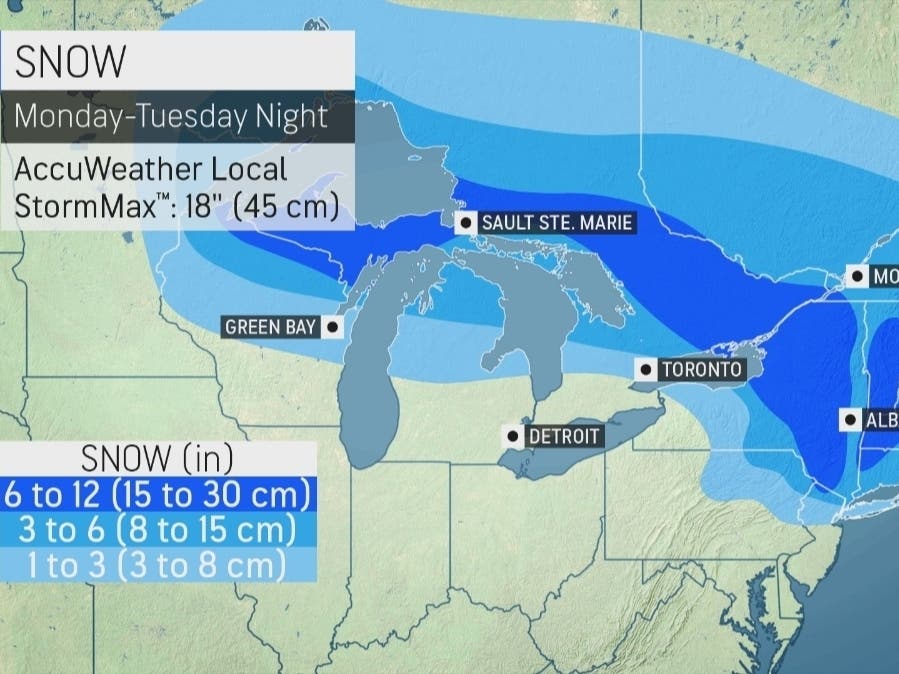
EASTERN PA — Snow is on the way to parts of eastern Pennsylvania Monday night, but forecasters say that most of the greater Philadelphia region will once again miss out and see chiefly rain. A second storm is tracking toward the area later in the week, however, that could bring snow.
While the storm will bring a taste of winter towards the conclusion of what's been an abnormally warm and snow-free season, it will just not get cold enough for snow Monday in the five-county region, according to forecasters.
Heavy snow will hit the northeastern part of the state above I-80, as up to 8 inches of snow is expected, the National Weather Service said. Meanwhile, the Allentown area could see up to 3 inches. But south of that is likely to be little more than dusting, if anything.
Find out what's happening in Norristownfor free with the latest updates from Patch.
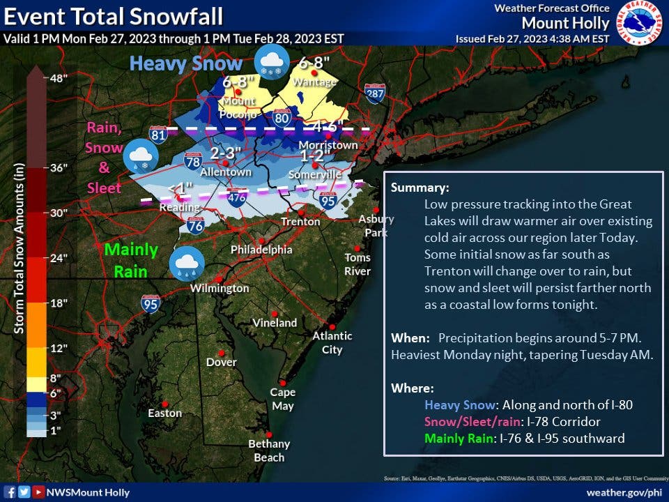
Instead, the impact from this storm for the Philly area will be all too familiar: rain.
"Farther south toward Philadelphia & Trenton, there might some brief sleet pellets or snowflakes initially, but expect mainly rain tonight," the National Weather Service's Mt. Holly, New Jersey branch said early Monday.
Find out what's happening in Norristownfor free with the latest updates from Patch.
Rainfall is likely to begin after 5 p.m., and be heaviest before 7 p.m., forecasters said. It could be mixed with some sleet late Monday night, as temperatures drop to 35 degrees overnight.
It'll still be enough to cause travel disruptions in the southeast, and could cause significant delays for those traveling up to Lehigh County or points farther north and east.
The second storm to hit this week will be Thursday and Thursday night, with impacts lingering into Friday morning, forecasters said. Both rain and snow are in the forecast for the Philadelphia area, although total precipitation estimates remain unclear this far out, and rain still appears to be the most likely impact.
"AccuWeather meteorologists say the latest forecasting data suggests that rain will be the primary form of precipitation from Washington, D.C., to New York City," AccuWeather said. "However, a more southern shift in the storm track could bring more wintry precipitation farther to the south in the mid-Atlantic and in southern New England."
Here's the full forecast for the coming week:
Monday
A chance of rain and sleet after 5pm. Increasing clouds, with a high near 46. North wind 5 to 10 mph becoming southeast in the afternoon. Chance of precipitation is 30 percent. Little or no sleet accumulation expected.
Monday night
Rain, possibly mixed with sleet, becoming all rain after 8pm. Low around 35. Southeast wind 10 to 15 mph becoming northeast after midnight. Chance of precipitation is 100 percent. Little or no sleet accumulation expected.
Tuesday
A chance of rain, mainly before 10am. Cloudy, then gradually becoming mostly sunny, with a high near 44. Northeast wind 5 to 10 mph becoming west in the afternoon. Chance of precipitation is 30 percent. New precipitation amounts of less than a tenth of an inch possible.
Tuesday night
Mostly clear, with a low around 32. Northwest wind around 5 mph.
Wednesday
Sunny, with a high near 54. Northeast wind 5 to 10 mph becoming south in the afternoon.
Wednesday night
A chance of showers after 1am. Mostly cloudy, with a low around 42. Chance of precipitation is 30 percent. New precipitation amounts of less than a tenth of an inch possible.
Thursday
A chance of showers before 1pm. Partly sunny, with a high near 62. Chance of precipitation is 40 percent.
Thursday night
Rain and snow likely, possibly mixed with sleet after 1am. Mostly cloudy, with a low around 36. Chance of precipitation is 60 percent.
Friday
Rain, possibly mixed with sleet, becoming all rain after 1pm. High near 48. Chance of precipitation is 90 percent.
Friday night
Rain likely, mainly before 1am. Mostly cloudy, with a low around 35. Breezy. Chance of precipitation is 60 percent.
Get more local news delivered straight to your inbox. Sign up for free Patch newsletters and alerts.


