Weather
Damaging Winds, Flooding, Plunging Temps In Philly Area Forecast
Gusts up to 50 miles per hour, heavy downpours, dramatically plummeting temperatures. The latest on the pre-Christmas tempest.

PHILADELPHIA, PA — Powerful, destructive winds, heavy rain, and drastically plummeting temperatures are on the way to the greater Philadelphia area as a huge winter stormfront impacting much of the nation continues to develop.
The storm, which is expected to bring blizzards to huge swaths of the midwest and which has thrown both road conditions and flight schedules at airports for a thousand miles into doubt, is now expected to arrive in eastern Pennsylvania by early Thursday afternoon, the National Weather Service said. The storm will continue through early Friday afternoon, forecasters believe, but that's just the beginning.
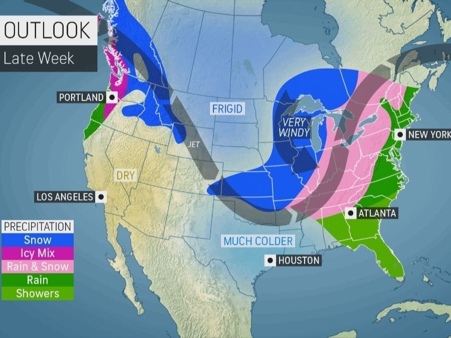
No significant ice or snow accumulation is expected locally, with only a few periods of freezing rain or sleet and flurries possible, forecasters say. For the most part, it will be too warm during the storm for the Philadelphia area to see any snow, but that doesn't mean there won't be significant local impacts.
Find out what's happening in Norristownfor free with the latest updates from Patch.
Up to three inches of precipitation could fall through early Friday afternoon, leading to localized flooding, the National Weather Service said. And gusts of up to 50 miles per hour are expected throughout the region, with gusts up to 60 possible on Friday due to a narrow squall line accompanying a cold front that will come through after the storm.
Impacts will continue after the storm, as potentially historically cold temperatures for Christmas Eve and Christmas Day are predicted, forecasters said. This could lead to a "dramatic flash freeze" for much of the northeast, AccuWeather said. Lows for much of the Philly area will be in the low teens or single digits on Friday and Saturday nights.
Find out what's happening in Norristownfor free with the latest updates from Patch.
"Any rain or snow that falls prior to the start of the holiday weekend is at risk of rapidly freezing, which will threaten treacherous conditions for traveling and walking," the outlet said.
"This is about as extreme of a temperature drop there can be in the Northeast," AccuWeather Senior Meteorologist Joe Lundberg added.
The snow that falls to the west will impact those who are looking to travel to and from the area. Specifically, blizzard conditions are expected in Illinois, Indiana, Michigan, Wisconsin, Iowa, Kansas, Nebraska, and Missouri, according to the latest forecast, with snow accumulating in nearly all of New York state west of the Hudson River Valley, all of Pennsylvania west of State College, and most of Ohio.
Flights out of several of the nation's largest airports, including Chicago, Detroit, and New York City are likely to be delayed, and AccuWeather noted that "ripple-effect delays from affected aircraft and crews will be felt across the nation."
RELATED: Airlines Offer Travel Waivers As Major Storm Approaches PA
Here is the latest forecast through Christmas, courtesy of the National Weather Service:
Wednesday
Mostly sunny, with a high near 41. North wind around 5 mph becoming east in the afternoon.
Wednesday night
Increasing clouds, with a low around 30. Northeast wind around 5 mph.
Thursday
Rain, mainly after 1pm. High near 51. Northeast wind 5 to 15 mph. Chance of precipitation is 90%. New precipitation amounts between a quarter and half of an inch possible.
Thursday night
Rain, with thunderstorms also possible after 4am. Low around 51. Breezy, with an east wind 15 to 25 mph, with gusts as high as 40 mph. Chance of precipitation is 100%. New rainfall amounts between three quarters and one inch possible.
Friday
Rain before 1pm, then a chance of snow. Some thunder is also possible. High near 52. Breezy, with a south wind around 25 mph becoming west in the afternoon. Winds could gust as high as 45 mph. Chance of precipitation is 90%. New snow accumulation of less than a half inch possible.
Friday night
Mostly clear, with a low around 12. Breezy.
Saturday
Mostly sunny, with a high near 22. Breezy.
Saturday night
Mostly clear, with a low around 14.
Christmas Day
Sunny, with a high near 25.
Sunday night
Mostly clear, with a low around 16.
Get more local news delivered straight to your inbox. Sign up for free Patch newsletters and alerts.