Weather
Heavier Rain, Hail In Eastern PA Nor'easter Forecast: Latest Updates
Shifting forecasts in the storm now call for more rain in southeastern Pennsylvania. Flooding is also likely. The latest:


PHILADELPHIA, PA — The powerful nor'easter heading to the region could now bring flash flooding to parts of eastern Pennsylvania, the National Weather Service said in their latest briefing issued Monday afternoon.
Flooding risk is now considered "elevated" for the region, after previous forecasts had much of the flooding risk for the region concentrated to New Jersey.
"The potential for heavy rain has increased," the National Weather Service said at 4 p.m. Monday. "The possibility of gale force winds on the coastal waters is also high. However, there remains more uncertainty about the threat of damaging wind gusts and minor tidal flooding."
Find out what's happening in Norristownfor free with the latest updates from Patch.
Previous forecasts called for 2 to 3 inches of rain in much of eastern Pennsylvania. Those estimates are now up to 3 to 4 inches. The potential for severe thunderstorms, as well as wind gusts up to 60 miles an hour, remains.
Up to an inch of hail is also possible. The risk for a tornado exists, but as of Monday evening was categorized as "low."
Find out what's happening in Norristownfor free with the latest updates from Patch.
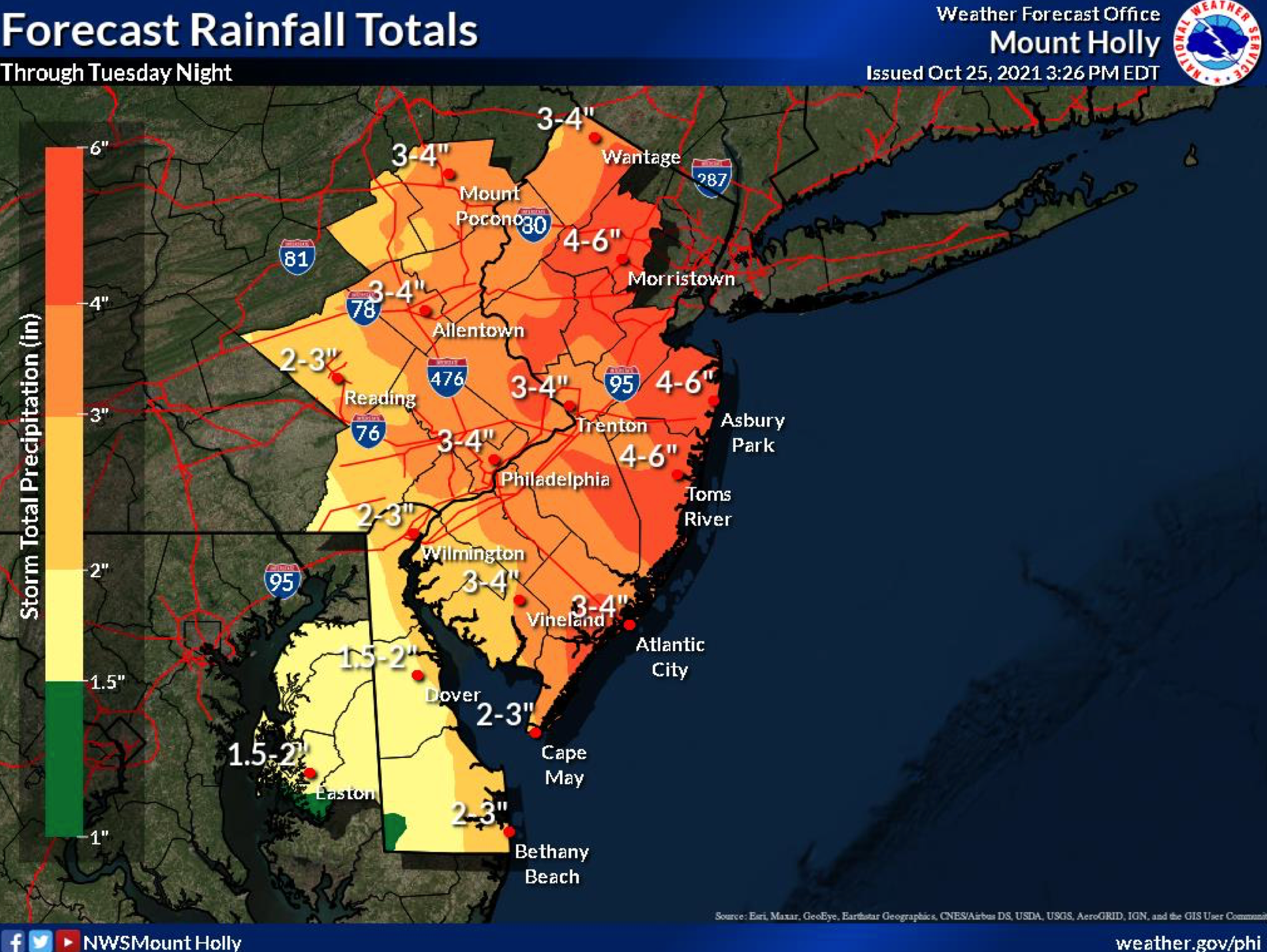
The heaviest impacts of the storm are still expected to impact the area by Monday evening and continue through Tuesday afternoon. The flash flood watch goes into effect at 8 p.m. Monday and will continue until Tuesday afternoon.
Montgomery, Bucks, Philadelphia, Lehigh, Carbon, Monroe, and Lehigh counties are all in the watch.
Though up to 4 inches is predicted for the area, higher amounts are possible in certain localized areas. "Flash flooding of creeks, streams, urban areas, and areas of poor drainage is possible with the heaviest rain," the National Weather Service added.
Here is the most recent forecast:
Monday
A chance of showers and thunderstorms. Mostly sunny, with a high near 78. South wind around 10 mph. Chance of precipitation is 30%. New rainfall amounts of less than a tenth of an inch, except higher amounts possible in thunderstorms.
Monday night
A chance of showers and thunderstorms, then showers and possibly a thunderstorm after 10pm. Some storms could be severe, with damaging winds and heavy rain. Low around 59. South wind around 5 mph becoming north after midnight. Chance of precipitation is 90%. New rainfall amounts between 1 and 2 inches possible.
Tuesday
Showers and possibly a thunderstorm before 9am, then showers likely. Some of the storms could be severe and produce heavy rainfall. High near 64. Northwest wind 10 to 15 mph, with gusts as high as 25 mph. Chance of precipitation is 80%. New precipitation amounts between 1 and 2 inches possible.
Tuesday night
Showers likely, mainly before 3am. Cloudy, with a low around 54. North wind 10 to 15 mph, with gusts as high as 25 mph. Chance of precipitation is 70%. New precipitation amounts between a quarter and half of an inch possible.
Wednesday
A chance of showers before 9am. Partly sunny, with a high near 65. North wind around 15 mph. Chance of precipitation is 30%. New precipitation amounts of less than a tenth of an inch possible.
Wednesday night
Mostly clear, with a low around 47.
Get more local news delivered straight to your inbox. Sign up for free Patch newsletters and alerts.


