Weather
Severe Storms, Flooding Possible This Week In Eastern PA: See The Timeline Here
The region is not getting a break from the severe weather. A flash flood watch has been issued with heavy rain on the way. Details:


PHILADLEPHIA, PA — With the greater Philadelphia area still recovering from the historic damage levied by the remnants of Hurricane Ida, more severe weather appears poised to hit later this week that could further test the area's infrastructure resiliency.
Slight rain is possible Wednesday, but the real inclement weather is slated to hit Thursday afternoon, mainly after 2 p.m. The National Weather Service is warning of bursts of heavy precipitation, potentially powerful wind gusts, and severe thunderstorms. Rainfall amounts of two to three inches are expected, with even stronger bursts possible in localized areas.
A flash flood watch will go into effect for all of southeastern and parts of central Pennsylvania at 2 p.m. Thursday. It will last until 8 a.m. Friday. The National Weather Service's scale indicates an "elevated" risk for excessive rainfall.
Find out what's happening in Norristownfor free with the latest updates from Patch.
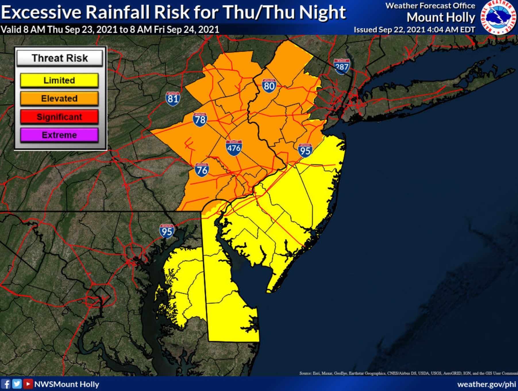
A cold front of low pressure coming from the west will hit a high pressure front coming off the coast, creating a potential "firehouse effect" of intense rain, AccuWeather says.
Counties in the flash flood watch include Carbon, Monroe, Berks, Lehigh, Northampton, Delaware, Philadelphia, Chester, Montgomery, and Bucks.
Find out what's happening in Norristownfor free with the latest updates from Patch.
Motorists are reminded not to drive through floodwaters and to always turn around if the safety of a road is in question.
Here's the forecast for the remainder of the week:
Wednesday
A slight chance of showers, then a chance of showers and thunderstorms after noon. Patchy fog before 10am. Otherwise, mostly cloudy, with a high near 82. South wind 5 to 15 mph. Chance of precipitation is 30%. New rainfall amounts of less than a tenth of an inch, except higher amounts possible in thunderstorms.
Wednesday night
A chance of showers and thunderstorms. Cloudy, with a low around 70. Southeast wind around 10 mph. Chance of precipitation is 50%. New precipitation amounts of less than a tenth of an inch, except higher amounts possible in thunderstorms.
Thursday
Showers likely, mainly after 2pm. Cloudy, with a high near 78. Southeast wind 10 to 15 mph. Chance of precipitation is 60%. New precipitation amounts between a quarter and half of an inch possible.
Thursday night
Showers and possibly a thunderstorm before 2am, then showers likely. Some of the storms could produce gusty winds and heavy rain. Low around 61. Southeast wind 5 to 10 mph becoming west after midnight. Chance of precipitation is 80%. New rainfall amounts between 1 and 2 inches possible.
Friday
A chance of showers before 2pm. Partly sunny, with a high near 72. Chance of precipitation is 40%.
Friday night
Patchy fog after 2am. Otherwise, mostly clear, with a low around 55.
Get more local news delivered straight to your inbox. Sign up for free Patch newsletters and alerts.


