Weather
Heavy Storm Coming To Eastern PA: Hazardous Outlook Issued
An isolated tornado is also possible.



More severe weather is expected in Pennsylvania this weekend as forecasters say thunder and lightning, high winds, and even an isolated tornado are possible.
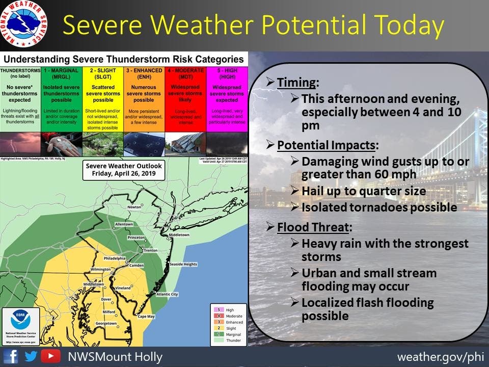
The National Weather Service has issued a hazardous weather outlook for Eastern Pennsylvania, saying several rounds of showers and thunderstorms will affect the area on Friday afternoon and will continue into the evening. Most of the storms are expected to happen between 4 and 10 p.m.
Some of the storms could be severe and produce damaging winds with isolated tornadoes also possible, according to the NWS.
Find out what's happening in Norristownfor free with the latest updates from Patch.
The greatest risk areas for severe weather will be across southeastern Pennsylvania, southern New Jersey, Delaware, and portions of eastern Maryland.
The quick-hitting round of thunderstorms has the potential to put lives, property and timely travel at risk from South Carolina to New Jersey and Pennsylvania on Friday, accordong to AccuWeather.
Find out what's happening in Norristownfor free with the latest updates from Patch.
The storms will be centered on the Interstate 95 corridor but will also extend as far west as portions of I-81 in Virginia, Maryland and Pennsylvania and to the barrier islands from North Carolina to New Jersey, according to AccuWeather.
There is also the likelihood of locally heavy, gusty thunderstorms farther north in New Jersey, southeastern New York state, including the New York City area, and parts of central and southern New England, according to AccuWeather.
-1556286167-3671.jpg)
While a tornado outbreak is not anticipated, there is the potential for a few brief tornadoes to be spawned in the strongest thunderstorms, according to AccuWeather. Strong wind gusts, frequent lightning strikes, blinding downpours and urban flooding will be more common threats from the storms.
Motorists may encounter sudden, blinding downpours and excess water on the roads, according to AccuWeather. Airline passengers can expect delays as the line of intense rainfall and gusty thunderstorms approaches and passes over airport locations.
The severe weather threat will end rapidly as cooler air sweeps in from west to east across the mid-Atlantic, according to AccuWeather. However, Friday evening will present the highest risk for the blinding downpours and gusty winds.
-1556286180-6120.jpg)
Here is the forecast:
- Friday: Showers and possibly a thunderstorm. Some of the storms could produce gusty winds and heavy rain. High near 72. South wind 8 to 13 mph, with gusts as high as 26 mph. Chance of precipitation is 90%. New rainfall amounts between a quarter and half of an inch possible.
- Friday night: Showers and possibly a thunderstorm before 1am, then a slight chance of showers between 1am and 2am. Some of the storms could produce gusty winds and heavy rain. Low around 49. West wind 9 to 14 mph. Chance of precipitation is 80%. New precipitation amounts between a tenth and quarter of an inch, except higher amounts possible in thunderstorms.
- Saturday: Mostly cloudy, then gradually becoming sunny, with a high near 62. Breezy, with a west wind 18 to 21 mph, with gusts as high as 34 mph.
- Saturday night: Increasing clouds, with a low around 48. West wind 5 to 15 mph.
- Sunday: A chance of showers. Mostly cloudy, with a high near 67. Light and variable wind becoming southwest 5 to 10 mph in the afternoon. Chance of precipitation is 30%. New precipitation amounts of less than a tenth of an inch possible.
- Sunday night: Mostly clear, with a low around 41.
Get more local news delivered straight to your inbox. Sign up for free Patch newsletters and alerts.


