Weather
Historic Warmth, Days Of Rain Forecasted In Philly Area
Temperatures will skyrocket to potentially record highs in the region for early January, threatening heat records over 70 years old.


EASTERN PA — After a topsy turvy holiday season that saw torrential rain, extreme cold, and temperature fluctuations from the 60s to the teens, more unusual weather is on the way to the greater Philadelphia area.
The new year will kick off with possibly historic warmth and several consecutive days of rain, forecasters said. It's part of a warm front surging across much of the midwest and northeast.
"The warm air will make it feel like spring has arrived several months ahead of schedule and challenge record highs that date back more than a century," AccuWeather said. " It may also be just warm enough for a new record high temperature to be reached in Philadelphia."
Find out what's happening in Norristownfor free with the latest updates from Patch.
Temperatures are predicted to soar above January averages, bringing the Philly region "anywhere from 15 degrees to nearly 25 degrees above the average high temperature for early January," the National Weather Service's Mt. Holly, New Jersey station added.
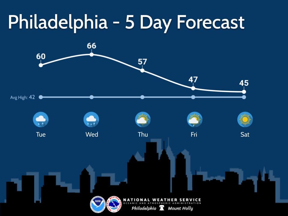
Tuesday and Wednesday will be the warmest days, with a high of 60 Tuesday and 66 Wednesday, forecasters said.
Find out what's happening in Norristownfor free with the latest updates from Patch.
Philadelphia's all time record of 63 degrees for Jan. 3 was set in 2000. Wednesday's all time record of 68 degrees was set in 1950.
Meanwhile, there is at least a chance of showers every day from Tuesday through Friday, with showers considered "likely" by the National Weather Service on Tuesday and Wednesday. Accumulation of a tenth of an inch is expected Tuesday, and up to a quarter of an inch on Wednesday.
Here is the full forecast for the week, according to the National Weather Service:
Tuesday
Rain likely, mainly before 3pm. Cloudy, with a high near 60. Light south wind increasing to 5 to 10 mph in the morning. Chance of precipitation is 60%. New precipitation amounts of less than a tenth of an inch possible.
Tuesday night
Mostly cloudy, with a low around 56. Southwest wind 10 to 15 mph.
Wednesday
Showers likely, mainly after 1pm. Cloudy, with a high near 66. Southwest wind 5 to 10 mph. Chance of precipitation is 70%. New precipitation amounts between a tenth and quarter of an inch possible.
Wednesday night
Showers likely, mainly before 1am. Mostly cloudy, with a low around 52. South wind around 5 mph becoming west after midnight. Chance of precipitation is 60%. New precipitation amounts of less than a tenth of an inch possible.
Thursday
A slight chance of showers. Partly sunny, with a high near 57. Northeast wind around 5 mph. Chance of precipitation is 20%.
Thursday night
A chance of showers. Mostly cloudy, with a low around 39. Chance of precipitation is 40%. New precipitation amounts of less than a tenth of an inch possible.
Friday
A chance of showers before 1pm. Partly sunny, with a high near 48. Chance of precipitation is 30%.
Friday night
Partly cloudy, with a low around 33.
Get more local news delivered straight to your inbox. Sign up for free Patch newsletters and alerts.


