Weather
Chance Of Snow In Mid-Week Storm Increases For PA: See Latest Forecast
The latest forecast has an improved chance of snow for the greater Philadelphia area later this week. Here's the latest:


EASTERN PA — As the large winter storm front moving across the nation approaches eastern Pennsylvania, forecasters are getting a clearer picture of what kind of impacts the local area may see.
The latest forecast has an improved chance of snow for the greater Philadelphia area Thursday, with the National Weather Service categorizing snowfall as "likely." However, at the moment, heavy rain appears to be the more dominant form of precipitation expected, according to forecasters.
Areas north of the city could experience light snow accumulation. Currently, accumulation estimates are less than an inch, with snow expected to stop by 10 a.m. Thursday.
Find out what's happening in Norristownfor free with the latest updates from Patch.
"Rain is the most likely form of precipitation in the Interstate 95 corridor from Boston to New York City, Philadelphia and Washington, D.C.," AccuWeather forecasters said. "The heavy rainfall, when combined with gusty winds, will lead to urban flooding and poor travel conditions. Motorists are likely to encounter ponding and poor visibility, while airline delays will be possible due to visibility, wind and slick runways at the major hubs."
The massive system will impact nearly the entire country when all is said and done, having already brought heavy rains and wind to the California coast before dumping snow across the plains and midwest, forecasters said. The southern states are likely to see rain.
Find out what's happening in Norristownfor free with the latest updates from Patch.
Further, AccuWeather says the front is likely to create a "spinoff" system in the Atlantic as it approaches the east coast. This could lead to heavy snow in parts of New England, but rain is predicted south of there.
Heavy rain will continue through the night into Friday, with up to two inches of precipitation overnight possible, the National Weather Service said.
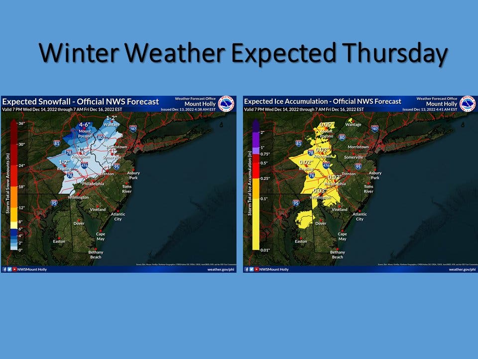
Here is the latest forecast, according to the National Weather Service:
Wednesday: Sunny, with a high near 40. Northwest wind around 10 mph.
Wednesday night: Mostly cloudy, with a low around 27. Northwest wind around 5 mph becoming northeast after midnight.
Thursday: Snow likely, possibly mixed with freezing rain before 11 am, then rain and snow likely between 11 am and 2 pm, then rain after 2pm. High near 42. Northeast wind 10 to 15 mph. Chance of precipitation is 90 percent. New ice accumulation of less than a 0.1 of an inch possible. New snow accumulation of less than a half inch possible.
Thursday night: Rain. Low around 40. Chance of precipitation is 100 percent. New precipitation amounts between 1 and 2 inches possible.
Friday: Rain, mainly before 2pm. High near 47. Chance of precipitation is 90 percent.
Friday night: Partly cloudy, with a low around 32.
Saturday: Mostly sunny, with a high near 41.
Saturday night: Mostly clear, with a low around 27.
Get more local news delivered straight to your inbox. Sign up for free Patch newsletters and alerts.


