Weather
More Severe PA Weather Expected As Holiday Weekend Arrives
Here is what to expect as more rough Pennsylvania weather – including strong winds and thunderstorms – is expected to arrive.


More severe weather – including strong winds and thunderstorms – is expected in southeastern Pennsyvlania as the holiday weekend arrives.
The National Weather Service has issued a hazardous weather outlook for the whole state, saying areas of heavy rain arriving later Friday and lasting into Saturday may result in some flooding. Some thunderstorms late Friday may produce locally strong winds.
-1555597187-5363.jpg)
Tidal flooding is expected with the high tide Friday night. There may also be some minor tidal flooding on back bays with the Friday morning high tide, according to the National Weather Service.
Find out what's happening in Norristownfor free with the latest updates from Patch.
AccuWeather says everyone across the northeastern United States will enjoy one last day featuring some sun and dry conditions before the system brings showers and thunderstorms to the region on Friday.
This is the same weather that is expected to rattle the Plains and Southeast with dangerous storm through the middle of the week, according to AccuWeather.
Find out what's happening in Norristownfor free with the latest updates from Patch.
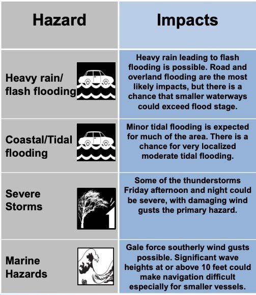
Here is what the National Weather Service says we should expect:
- Heavy rain leading to flash flooding is possible later Friday into Saturday, with the highest threat during Friday night when heavier showers could move over the same areas for a time. Some smaller waterways could exceed flood stage.
- Some of the thunderstorms Friday afternoon and Friday night could be severe with damaging winds.

Anyone traveling through the Northeast ahead of the holiday weekend or to Good Friday events will face newly slick roads and limited visibility, according to AccuWeather. In general, the heaviest rounds of rain are expected to impact New Jersey, New York and the rest of the mid-Atlantic.
Airline delays are likely, according to AccuWeather.
In addition to flooding downpours, strong winds could further threaten the region by snapping branches and toppling trees, according to AccuWeather.
Late Friday through Saturday, a surge of heavy, gusty downpours are also expected to move through the region, according to AccuWeather. Flooding is likely to develop during this time in low-lying and poor-drainage areas, and anywhere the ground is already saturated.
-1555597173-743.jpg)
Here is the forecast, according to the National Weather Service:
- Thursday: A slight chance of showers before 11am. Mostly cloudy, with a high near 78. Southeast wind 9 to 11 mph becoming south in the afternoon. Chance of precipitation is 20%.
- Thursday night: Mostly cloudy, with a low around 62. South wind 10 to 13 mph.
- Friday: A chance of showers before 2pm, then a chance of showers and thunderstorms between 2pm and 5pm, then showers likely and possibly a thunderstorm after 5pm. Cloudy, with a high near 74. South wind 13 to 18 mph, with gusts as high as 29 mph. Chance of precipitation is 60%. New rainfall amounts between a quarter and half of an inch possible.
- Friday night: Showers and possibly a thunderstorm. Some of the storms could produce heavy rainfall. Low around 63. South wind 15 to 18 mph, with gusts as high as 28 mph. Chance of precipitation is 100%. New rainfall amounts between three quarters and one inch possible.
- Saturday: Showers, mainly before 11am. High near 69. South wind 14 to 16 mph. Chance of precipitation is 80%. New precipitation amounts between a tenth and quarter of an inch possible.
- Saturday night: Scattered showers, mainly after 2am. Partly cloudy, with a low around 52. Chance of precipitation is 30%.
- Sunday: Scattered showers. Partly sunny, with a high near 66. Chance of precipitation is 30%.
- Sunday night: Partly cloudy, with a low around 52.
With reporting from Patch correspondent Tom Davis
Get more local news delivered straight to your inbox. Sign up for free Patch newsletters and alerts.


