Weather
Multiple Storm Systems Could Hit Eastern PA In Coming Week: Forecast
Several storm systems are heading to the region this week, forecasters said.


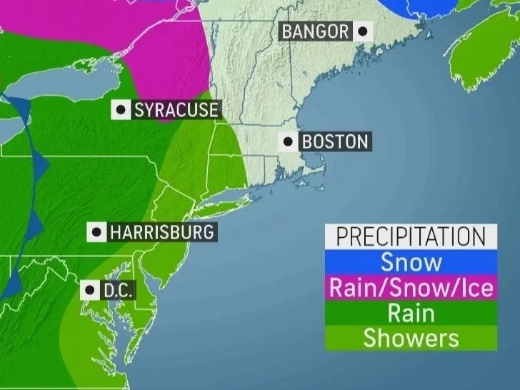
EASTERN PA — Multiple storm fronts could impact the greater Philadelphia area this week, forecasters said, including potentially heavy rain. It does not appear these storms will bring local snow to the area, meaning the region's historic snow drought has a good chance of continuing.
Some showers are xpected on Tuesday from the late morning into the afternoon, but this will not be the storm to watch out for, according to the National Weather Service. Only up to a tenth of an inch is expected.
Forecasters expect heavier rain Wednesday night into Thursday, and throughout the day Thursday. Up to three quarters of an inch could fall, and there's a chance for flooding and impacts to the evening commute, forecasters said.
Find out what's happening in Norristownfor free with the latest updates from Patch.
Rain is likely to continue into the evening hours, where another quarter of an inch could fall.
Philadelphia's historic snow drought could very well continue, as it does not appear like temperatures will be cold enough for most of eastern Pennsylvania to see snow.
Find out what's happening in Norristownfor free with the latest updates from Patch.
Not a single drop of snow has fallen in Philadelphia in January. "So far this month, Philadelphia has 0.0" of snow, not even a trace (but they do have 1 day of thunder!). There is no January on record since 1873 with 0.0" of snow," the National Weather Service's Mt. Holly, New Jersey station said.
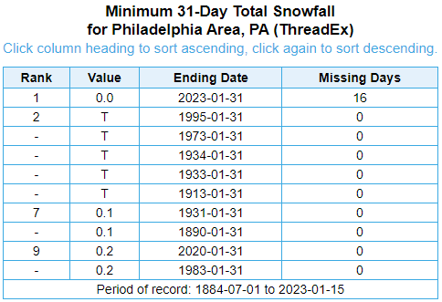
Weather will clear up Friday, with partly sunny skies and highs in the 50s.
Check AccuWeather's Pennsylvania radar for local conditions.
Here's the forecast for the remainder of the week, according to the National Weather Service:
Tuesday
A chance of rain, mainly between noon and 3pm. Cloudy, with a high near 45. Southwest wind around 5 mph. Chance of precipitation is 30%. New precipitation amounts of less than a tenth of an inch possible.
Tuesday night
Mostly cloudy, with a low around 40. Southwest wind around 5 mph.
Wednesday
Mostly sunny, with a high near 55. West wind 5 to 15 mph, with gusts as high as 25 mph.
Wednesday night
A chance of rain, mainly after 4am. Increasing clouds, with a low around 39. West wind 5 to 10 mph becoming light northwest after midnight. Chance of precipitation is 40%. New precipitation amounts of less than a tenth of an inch possible.
Thursday
Rain, mainly after 7am. High near 48. Calm wind becoming east around 5 mph in the morning. Chance of precipitation is 100%. New precipitation amounts between a half and three quarters of an inch possible.
Thursday night
A chance of rain before 1am. Mostly cloudy, with a low around 40. Chance of precipitation is 50%. New precipitation amounts between a tenth and quarter of an inch possible.
Friday
Partly sunny, with a high near 50.
Friday night
Partly cloudy, with a low around 33.
Get more local news delivered straight to your inbox. Sign up for free Patch newsletters and alerts.


