Weather
Bomb Cyclone Snow Forecast Updated In Philly Area: Expected Totals
The National Weather Service has released new details concerning a powerful storm that will impact the Philly area this weekend.


PHILADELPHIA, PA — Forecasters say the powerful "bomb cyclone" storm on its way to the greater Philadelphia area will now bring snow and a rapid temperature drop, in addition to the powerful winds and rain previously predicted.
AccuWeather meteorologists note that the storm could undergo bombogenesis status, meaning a low-pressure area that undergoes rapid strengthening and "explosive development."
Rain will begin late Friday into early Saturday morning, before gradually shifting to snow northwest of the I-95 corridor, National Weather Service forecasters said. Rain will be heavy at times, with up to a quarter of an inch accumulating.
Find out what's happening in Norristownfor free with the latest updates from Patch.
The temperature will rapidly drop from Friday's high of 59 to around 32 degrees by 5 p.m. Saturday, forecasters said.
This swift change could produce dangerous icy road conditions, the National Weather Service warned.
Find out what's happening in Norristownfor free with the latest updates from Patch.
While the storm could lead up to 6 inches in the Poconos and parts of North Jersey, it's likely only to bring brief periods of snow in southeastern Pennsylvania.
Up to half an inch of snow could fall by late Saturday, with most precipitation stopping by around 10 p.m. However, forecasters note there is a possibility for much more than that, depending how the storm develops:
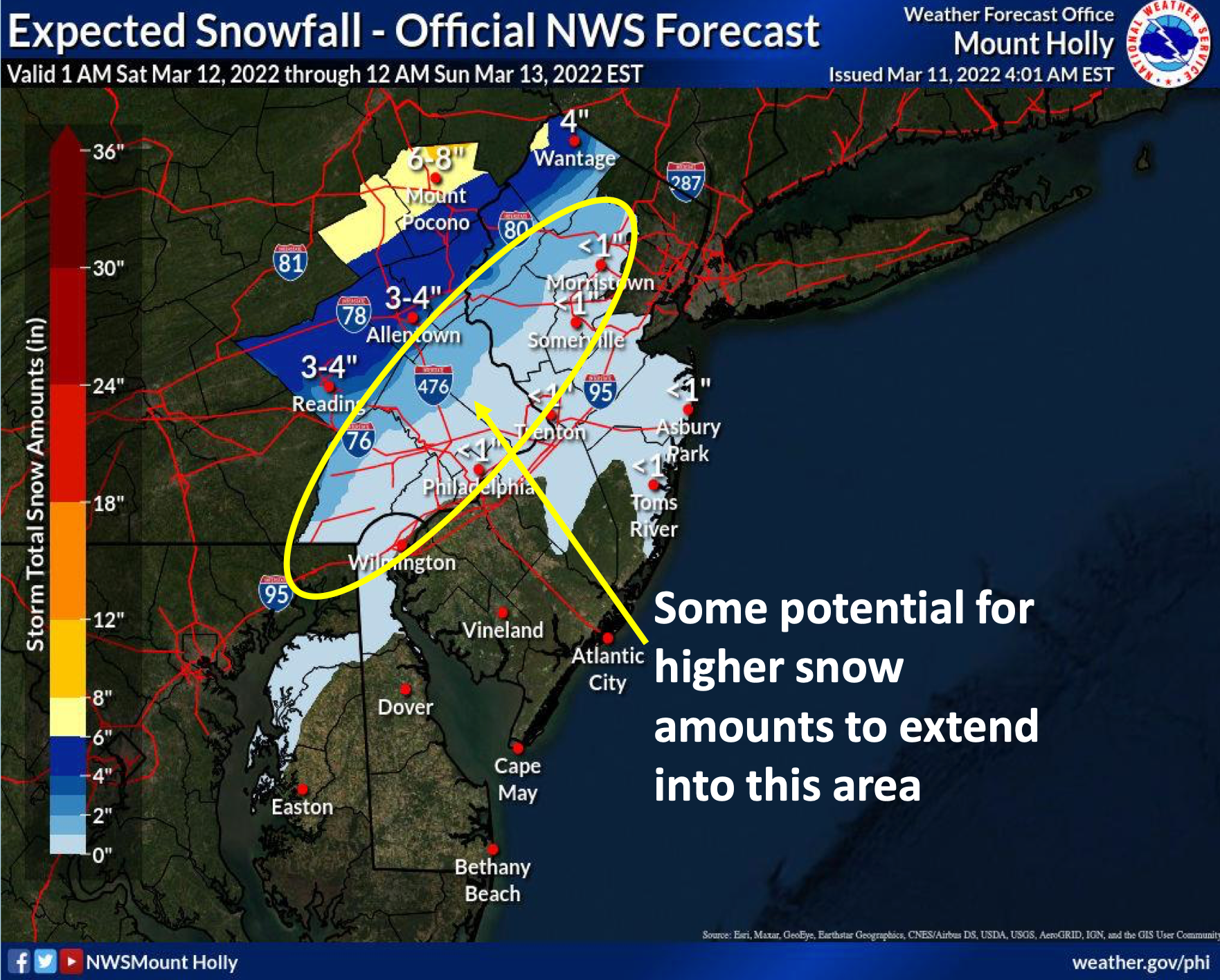
Winds will accompany the storm, with gusts up to 25 miles per hour on Saturday.
The ominously named phenomenon called bomb cyclone, or bombogenesis, happens when a low-pressure system drops at least 24 millibars within 24 hours. Such drops are characterized by sudden, unpredictable waves of high winds and snow, meteorologists warn.
Here's the full forecast through the weekend:
Friday
Sunny, with a high near 59. South wind 5 to 10 mph.
Friday night
Rain, mainly after 10pm. Low around 44. Southeast wind around 5 mph. Chance of precipitation is 90%. New precipitation amounts between a tenth and quarter of an inch possible.
Saturday
Rain before 3pm, then snow. Temperature falling to around 32 by 5pm. Breezy, with a northwest wind 10 to 15 mph increasing to 20 to 25 mph in the afternoon. Chance of precipitation is 100%. New snow accumulation of less than a half inch possible.
Saturday night
A slight chance of snow before 10pm. Mostly cloudy, then gradually becoming mostly clear, with a low around 20. Blustery, with a west wind 20 to 25 mph. Chance of precipitation is 20%.
Sunday
Sunny, with a high near 37. West wind 10 to 15 mph, with gusts as high as 25 mph.
Sunday night
Mostly clear, with a low around 30.
Get more local news delivered straight to your inbox. Sign up for free Patch newsletters and alerts.


