Weather
Tornado Watch Issued In 34 PA Counties: See Timeline
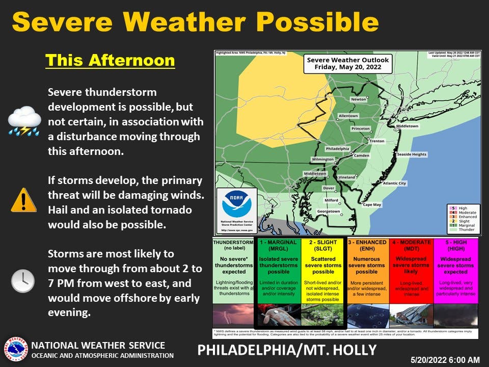
Tornados could be on the way to the region on Friday, forecasters warned.


PHILADELPHIA, PA — A tornado watch has been issued for 34 counties across Pennsylvania on Friday afternoon as a severe weather front makes a turn for the region.
Storms are likely to arrive around 2 p.m., with the most serious impacts likely before 7 p.m. The watch is in effect until 7 p.m.
Scattered winds of up to 70 mph are likely, while isolated hail of up to 2 inches is possible, forecasters say.
Find out what's happening in Norristownfor free with the latest updates from Patch.
The impacted counties in the tornado watch include all of the greater Philadelphia area and eastern Pennsylvania, including Adams, Bedford, Bucks, Berks, Carbon, Blair, Centre, Chester, Columbia, Cumberland, Dauphin, Delaware, Frankllin, Fulton, Huntingdon, Juniata, Lackawanna, Lancaster, Lebanon, Lehigh, Luzerne, Mifflin, Montour, Montgomery, Northampton, Monroe, Northumberland, Perry, Philadelphia, Pike, York, Schuylkill, Snyder, and Union counties.

A watch is an advisory of a future event, while a warning indicates that the threat is imminent, the National Weather Service says. A watch indicates that "tornadoes are possible in and near the watch area. Review and discuss your emergency plans and check supplies and your safe room. Be ready to act quickly if a warning is issued or you suspect a tornado is approaching. Acting early helps to save lives."
Find out what's happening in Norristownfor free with the latest updates from Patch.
Beyond the tornado chance, the front could include damaging winds and severe thunderstorms, forecasters said.
Original story
The front could bring it with severe thunderstorms and hail as well, the National Weather Service said. However, forecasters are noting that the storm is bringing with it a high degree of variability.
"However, it is a low confidence forecast and we encourage you to monitor for updates, as we are admittedly uncertain how the storm threat will play out today," the National Weather Service's Mt. Holly branch shared on social media.
Storms are likely to hit at some point in the later afternoon, with 2 p.m. to 7 p.m. being the primary range, forecasters said.
Following the showers on Friday, the area is likely to see temperatures rise quickly, with a heat advisory issued for the greater Philadelphia area.
Temperatures up to 100 degrees are expected in parts of the region, with the advisory to take effect from 11 a.m. to 10 p.m. Saturday. It will be the hottest weather since last summer, Accuweather says.
“Drink plenty of fluids, stay in an air-conditioned room, stay out of the sun, and check up on relatives and neighbors,” the National Weather Service said. “Young children and pets should never be left unattended in vehicles under any circumstances.”
Here’s the latest forecast:
Friday
Showers and thunderstorms likely, mainly after 5pm. Partly sunny, with a high near 86. South wind 5 to 10 mph, with gusts as high as 20 mph. Chance of precipitation is 60%. New rainfall amounts of less than a tenth of an inch, except higher amounts possible in thunderstorms.
Friday night
A chance of showers and thunderstorms before 7pm. Mostly cloudy, with a low around 69. South wind around 5 mph becoming calm after midnight. Chance of precipitation is 30%. New precipitation amounts of less than a tenth of an inch, except higher amounts possible in thunderstorms.
Saturday
Mostly sunny and hot, with a high near 97. Southwest wind 5 to 10 mph.
Saturday night
Partly cloudy, with a low around 74. Southwest wind around 5 mph.
Sunday
A chance of showers and thunderstorms after 2pm. Mostly sunny, with a high near 92. Southwest wind 5 to 10 mph, with gusts as high as 20 mph. Chance of precipitation is 30%. New rainfall amounts of less than a tenth of an inch, except higher amounts possible in thunderstorms.
Sunday night
A chance of showers and thunderstorms before 2am. Mostly cloudy, with a low around 66. Chance of precipitation is 40%. New rainfall amounts of less than a tenth of an inch, except higher amounts possible in thunderstorms.
Get more local news delivered straight to your inbox. Sign up for free Patch newsletters and alerts.


