Weather
Derecho Could Hit Philly Area With Severe Wind, Thunderstorms
The potential "inland hurricane" could bring damaging winds, severe thunderstorms, and rain, though forecasters say they remain uncertain.


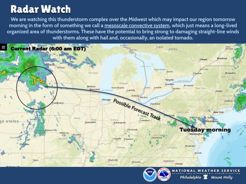
PHILADLEPHIA, PA — The greater Philadelphia area could be impacted by the edge of a massive band of powerful thunderstorms this week that forecasters are warning may turn into the rare weather phenomenon known as a derecho.
The thunderstorm complex is forming across the Midwest and to the Atlantic coast, with the strongest parts of it likely to impact Wisconisin to West Virginia, according to Accuweather. It could bring with it torrential rains, hail, and destructive winds.
The greater Philadelphia region is right along the edge of the path, according to the latest forecasts. Accuweather indicates "some" likelihood that severe weather from this storm front will impact the southeastern corner of Pennsylvania and some of South Jersey.
Find out what's happening in Norristownfor free with the latest updates from Patch.
"There are some questions as to the path, longevity and extent of the thunderstorm complex, but there is no doubt of the likelihood of at least isolated severe storms over hundreds of miles," Accuweather notes, citing meteorologist Bernie Rayno.
"Derecho" refers to widespread, long-lasting, destructive straight-line winds. The term for the fast-moving winds was coined in 1888 to differentiate the weather pattern from that of tornadoes. To become a derecho, a storm must generate winds of at least 58 miles per hour along an area of 240 miles or more.
Find out what's happening in Norristownfor free with the latest updates from Patch.
The National Weather Service says that some showers and thunderstorms could begin after 2 p.m. Monday, but the bulk of the storms are anticipated to reach the area early Tuesday.
"Some of the storms could produce small hail, gusty winds, and heavy rain," in the Philadelphia area, weather experts said.
Here's the latest forecast from the National Weather Service:
Monday
A slight chance of showers and thunderstorms after 2pm. Partly sunny, with a high near 88. West wind around 5 mph. Chance of precipitation is 20%.
Monday night
Mostly cloudy, with a low around 67. West wind around 5 mph becoming calm in the evening.
Tuesday
A chance of showers and thunderstorms, mainly before 1pm. Some of the storms could produce small hail, gusty winds, and heavy rain. Mostly cloudy, with a high near 81. Northeast wind around 5 mph. Chance of precipitation is 30%. New rainfall amounts of less than a tenth of an inch, except higher amounts possible in thunderstorms.
Tuesday night
A slight chance of showers after midnight. Partly cloudy, with a low around 66. Northwest wind around 5 mph becoming calm. Chance of precipitation is 20%.
Wednesday
A slight chance of showers before 9am. Mostly sunny, with a high near 87. Northeast wind around 5 mph becoming southeast in the afternoon. Chance of precipitation is 20%.
Wednesday night
A chance of showers after 9pm. Partly cloudy, with a low around 66. Chance of precipitation is 40%. New precipitation amounts of less than a tenth of an inch possible.
Thursday
A chance of showers. Partly sunny, with a high near 86. Chance of precipitation is 40%.
Thursday night
A chance of showers before 9pm, then showers likely and possibly a thunderstorm between 9pm and 3am, then a chance of showers after 3am. Mostly cloudy, with a low around 72. Chance of precipitation is 60%.
Friday
A chance of showers. Mostly sunny, with a high near 90. Chance of precipitation is 50%.
Friday night
A chance of showers before 9pm. Mostly clear, with a low around 66. Chance of precipitation is 30%.
Get more local news delivered straight to your inbox. Sign up for free Patch newsletters and alerts.


