Weather
Hurricane Ian's Remnants To Bring Flooding, Days Of Rain To Philly Area
Days of rain, wind gusts, and potential flooding could hit the area as the remnants of the devastating storm continue up the coast.


EASTERN PA — Days of heavy rain and wind gusts are likely to continue to hammer the greater Philadelphia region as the remnants of what was once Hurricane Ian expend themselves along the Atlantic seaboard.
Rain will continue to fall through Wednesday night, according to the National Weather Service. While southeastern Pennsylvania will not receive quite the impacts of the Jersey Shore — where up to 3 more inches of rain will fall — the city and suburbs could still receive another inch. That, combined with the rain that has already fallen, could contribute to flooding in certain waterways, forecasters say.

Find out what's happening in Norristownfor free with the latest updates from Patch.
"Widespread (freshwater) flooding is not expected, but rain could exacerbate tidal flooding,"
the National Weather Service adds, as the Schuylkill River and its major tributaries are not predicted to flood. The Delaware River, however, could flood at multiple points in Philadelphia and nearby. The river will peak at 8.8 feet at around 10 p.m. Monday, Tuesday, and Wednesday nights, in the "minor" flood stage and just shy of the "moderate" stage, forecasters say.
Find out what's happening in Norristownfor free with the latest updates from Patch.

While the coast could see wind gusts nearing 50 miles an hour, it's likely to peak at around 26 miles an hour in the Philadelphia area. Conditions could still be ripe for property damage.
"Locations that receive a soaking rainfall during the stormy stretch may be at a greater risk of experiencing some extent of damage due to the wind," AccuWeather forecasters said. "Trees sitting in saturated soil have an even higher likelihood of toppling over even in a moderate wind gust."
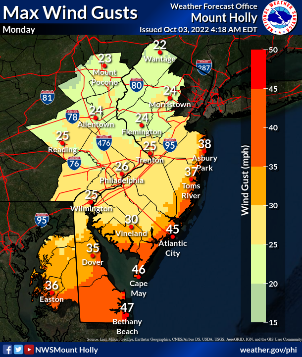
The storm is comprised of pieces of energy left over from Ian, which devastated Florida and the Carolinas last week. The death toll in Florida reached 88 people, as 600,000 remain in the Sunshine State remain without power as of Monday morning. Four people in North Carolina died in storm-related incidents since Friday morning, according to Gov. Roy Cooper.
Here's the latest forecast:
Monday
Showers likely. Cloudy, with a high near 54. Northeast wind around 15 mph, with gusts as high as 30 mph. Chance of precipitation is 70%. New precipitation amounts of less than a tenth of an inch possible.
Monday night
A chance of showers. Cloudy, with a low around 46. Northeast wind around 10 mph, with gusts as high as 20 mph. Chance of precipitation is 50%. New precipitation amounts of less than a tenth of an inch possible.
Tuesday
Showers likely. Cloudy, with a high near 55. North wind around 15 mph, with gusts as high as 25 mph. Chance of precipitation is 60%. New precipitation amounts between a quarter and half of an inch possible.
Tuesday night
Showers likely, mainly before 9pm. Mostly cloudy, with a low around 51. North wind around 15 mph, with gusts as high as 25 mph. Chance of precipitation is 60%. New precipitation amounts between a quarter and half of an inch possible.
Wednesday
A chance of showers, mainly before 9am. Mostly cloudy, with a high near 65. North wind around 15 mph. Chance of precipitation is 40%. New precipitation amounts of less than a tenth of an inch possible.
Wednesday night
A slight chance of showers before 9pm. Partly cloudy, with a low around 50. Chance of precipitation is 20%.
Get more local news delivered straight to your inbox. Sign up for free Patch newsletters and alerts.


