Weather
Ice Storm With 'Elevated Risk' Headed To Philly Area: Latest Forecast
Temperatures could reach 70 on Wednesday before ceding to a snow and ice storm on Thursday that could impact power, traffic, and more.


PHILADELPHIA, PA — A hazardous weather outlook has been issued for the greater Philadelphia area as a snow and ice storm is on the way to close out the week, forecasters said, despite the fact that high temperatures will approach 70 degrees Wednesday. The National Weather Service says the risk impacts from the ice is "elevated."
Precipitation will move into the area after 2 p.m. on Thursday afternoon, according to the National Weather Service. It will be heaviest in the Lehigh Valley and southern Poconos.
"Snow will transition to sleet then freezing rain Thursday night into Friday morning from south to north," forecasters said. "A transition to plain rain is likely to occur early Friday morning south and east of I-95. Lower confidence in how far north and east freezing rain occurs and when the transition from sleet to freezing rain will occur."
Find out what's happening in Norristownfor free with the latest updates from Patch.
Less than an inch of snow is expected for most of the region. The more significant impact is expected to be the ice, which could accumulate up to two tenths of an inch, causing some tree damage and power outages.
The storm is also likely to impact the morning commute on Thursday, with travel conditions becoming dicey as roads slick over with ice.
Find out what's happening in Norristownfor free with the latest updates from Patch.
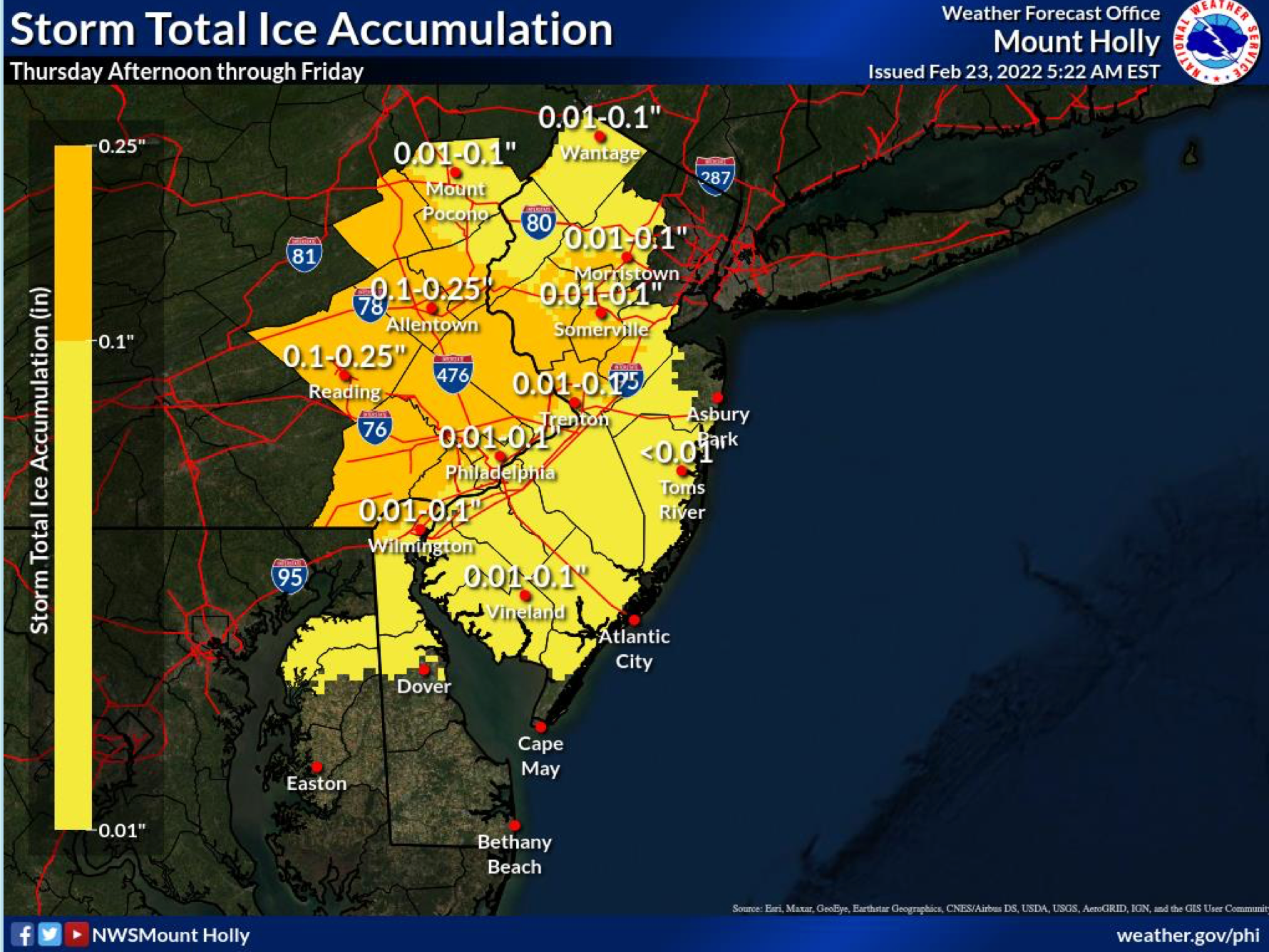
Here's the latest forecast:
Wednesday
Isolated showers between noon and 2pm. Cloudy early, then gradual clearing, with a high near 70. Breezy, with a west wind 10 to 15 mph increasing to 15 to 20 mph in the afternoon. Winds could gust as high as 30 mph. Chance of precipitation is 20%.
Wednesday night
Increasing clouds, with a low around 32. Northwest wind 10 to 15 mph, with gusts as high as 30 mph.
Thursday
A slight chance of rain, snow, and sleet after 2pm. Mostly cloudy, with a high near 35. North wind around 5 mph becoming east in the afternoon. Chance of precipitation is 20%.
Thursday night
Rain or freezing rain before midnight, then freezing rain between midnight and 4am, then rain after 4am. Low around 32. East wind 5 to 10 mph. Chance of precipitation is 100%. New ice accumulation of less than a 0.1 of an inch possible.
Friday
Rain, mainly before 2pm. High near 44. East wind 5 to 15 mph becoming west in the afternoon. Chance of precipitation is 100%. New precipitation amounts between a half and three quarters of an inch possible.
Friday night
A slight chance of rain before 8pm. Partly cloudy, with a low around 24. Chance of precipitation is 20%.
Saturday
Mostly sunny, with a high near 37.
Saturday night
Partly cloudy, with a low around 26.
Sunday
Mostly sunny, with a high near 45.
Sunday night
Partly cloudy, with a low around 23.
Get more local news delivered straight to your inbox. Sign up for free Patch newsletters and alerts.