Weather
Heavy Rainfall, Thunderstorms In Philly Area Forecast
Localized torrential rain and damaging wind is approaching the region, forecasters say, with several days of thunderstorms threatening.


PHILADELPHIA, PA — The greater Philadelphia area is in for several days of potentially heavy rainfall and thunderstorms, according to the latest forecasts.
A storm front bringing localized heavy rainfall, accompanied by strong wind gusts and thunderstorms, is moving in a wide band across the midwest and will approach southastern Pennsylvania at some point after 3 p.m. Wednesday, the National Weather Service said.
Thursday should remain relatively dry in the morning, with more rounds of rain coming in the afternoon. The greatest chances for “appreciable rainfall” and thunderstorms will be mostly south of the Philadelphia metro area. Temperatures will be modestly cooler with a high around 82, the National Weather Service said.
Find out what's happening in Norristownfor free with the latest updates from Patch.
A noticeable drop in humidity is expected Friday, with his in the low- to mid-80s and widespread showers and thunderstorms, the weather agency said.
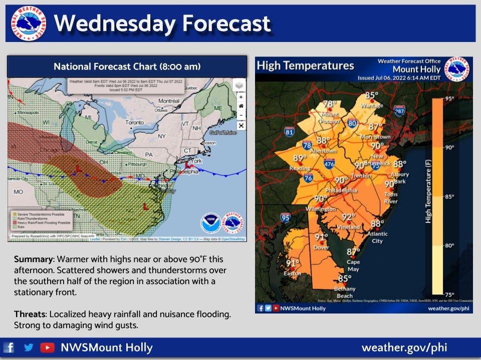
Here's the full forecast:
Find out what's happening in Norristownfor free with the latest updates from Patch.
Wednesday
Partly sunny, with a high near 90. Northwest wind 5 to 10 mph.
Wednesday night
A slight chance of showers after 3am. Mostly cloudy, with a low around 72. North wind around 5 mph becoming northeast after midnight. Chance of precipitation is 20%.
Thursday
A chance of showers, mainly after 9am. Mostly cloudy, with a high near 83. East wind 5 to 10 mph. Chance of precipitation is 40%. New precipitation amounts between a quarter and half of an inch possible.
Thursday night
A chance of showers. Mostly cloudy, with a low around 71. Southeast wind around 5 mph. Chance of precipitation is 50%. New precipitation amounts between a quarter and half of an inch possible.
Friday
Showers likely, mainly between 9am and noon. Mostly cloudy, with a high near 85. South wind around 5 mph becoming west in the afternoon. Chance of precipitation is 60%. New precipitation amounts between a tenth and quarter of an inch possible.
Friday night
Showers likely and possibly a thunderstorm before 9pm, then a chance of showers. Mostly cloudy, with a low around 70. Chance of precipitation is 60%. New precipitation amounts of less than a tenth of an inch, except higher amounts possible in thunderstorms.
Saturday
Mostly sunny, with a high near 84.
Saturday night
Mostly clear, with a low around 64.
Sunday
Sunny, with a high near 82.
Sunday night
Mostly clear, with a low around 63.
Get more local news delivered straight to your inbox. Sign up for free Patch newsletters and alerts.


