Weather
Snowstorm Approaching Eastern PA: Latest Forecast, Accumulation
Another round of snow is in the forecast, with several inches of snow possible in the Philly area. See the latest:


EASTERN PA — Another round of snow is in the forecast for Thursday night that could bring up to four inches of snow to parts of southeastern Pennsylvania, forecasters said.
A period of moderate to heavy snow is expected to fall across most of the region Thursday night through Friday morning, according to the National Weather Service.
Widespread snowfall accumulations of at least 2 to 4 inches are expected along and southeast of the Interstate 95 corridor.
Find out what's happening in Norristownfor free with the latest updates from Patch.
Most of the snow is likely to fall in a short period from midnight to 6 a.m. Friday.
As with any storm, there is some degree of uncertainty as to accumulation. Areas to the north and west are likely to receive less snowfall, while areas along the Delaware River look to receive four inches.
Find out what's happening in Norristownfor free with the latest updates from Patch.
However, the National Weather Service said that "confidence remains high" that the majority of the Philadelphia region will receive notable accumulations of snow. A hazardous weather outlook has been put in place, with warnings that travel could be significantly impacted.
Temperatures will be in the mid 20s to low 30s as snow falls Thursday night.
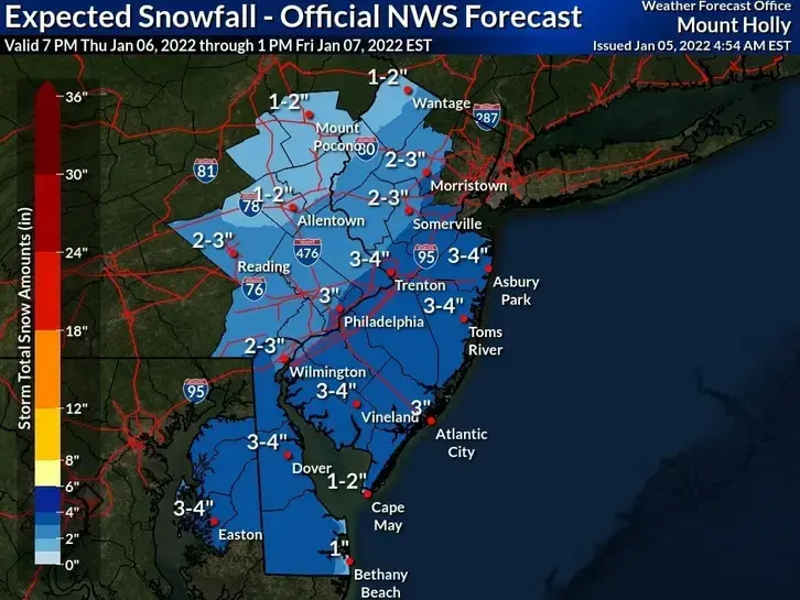
Here's the latest forecast:
Wednesday
A chance of rain, mainly before 11am. Cloudy, with a high near 45. Southwest wind 5 to 10 mph. Chance of precipitation is 30%. New precipitation amounts of less than a tenth of an inch possible.
Wednesday night
Cloudy, then gradually becoming partly cloudy, with a low around 33. West wind 5 to 10 mph.
Thursday
Partly sunny, with a high near 38. West wind 5 to 10 mph.
Thursday night
Snow, mainly after 1am. Low around 28. West wind around 5 mph becoming north after midnight. Chance of precipitation is 80%. New snow accumulation of 1 to 3 inches possible.
Friday
A chance of snow before 1pm. Partly sunny, with a high near 34. West wind 10 to 15 mph. Chance of precipitation is 30%. New snow accumulation of less than one inch possible.
Friday night
Mostly clear, with a low around 18.
Saturday
Sunny, with a high near 31.
Saturday night
Mostly clear, with a low around 20.
Sunday
A chance of snow showers before 10am, then a chance of rain and snow showers between 10am and 1pm, then rain showers likely after 1pm. Mostly cloudy, with a high near 43. Chance of precipitation is 70%.
Sunday night
A chance of showers before 1am. Mostly cloudy, with a low around 30. Chance of precipitation is 40%.
With reporting from Patch correspondent Kim Bongard
Get more local news delivered straight to your inbox. Sign up for free Patch newsletters and alerts.


