Winter 2012 is shaping up as one of the mildest on record in the region. For Philadelphia, it's probably going to end up as the fourth or fifth warmest on record as meteorological winter comes to a merciful (for the snow-starved among you) end on Wednesday. For us weather folk out there, spring starts on March 1. Meteorologists like to keep weather data organized on a monthly basis, and March, April, May make up the three months of meteorological spring.
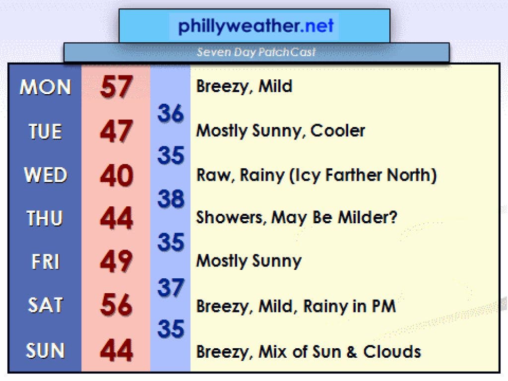
The coming week will promise a varied litany of weather -- from a mild start on Monday to a rainy and raw Wednesday, followed by a nice Friday and then more rain on Saturday. Monday may end up as the mildest day of the coming week as temperatures flirt with 60 near Philadelphia and in the mid or upper 50s in many of the suburbs. It'll be a nice, but breezy, day. A cool front crosses later Monday night, with cool sunshine settling in on Tuesday. While still nice, Tuesday will be close to 10 degrees cooler as a cold high pressure center over Canada oozes some Canadian chill southward into the U.S.
February will end on a rainy note around here, with the potential for some snowy and icy travel up to our north over the Poconos on Wednesday as a storm system moves in from the west. If it weren't for that Canadian high pressure center, we'd be talking about a warm and rainy setup with temperatures running towards 60. However, the chilled high is going to act as a roadblock and prevent a storm system over the Great Lakes from pushing warmth northward. Instead, this storm system will be shoved east through our part of the world, eventually transferring its energy to a low pressure center developing in the Atlantic.
Find out what's happening in Perkiomen Valleyfor free with the latest updates from Patch.
The day with the most temperature and weather uncertainty is Thursday. We currently have Thursday pegged for the middle 40s but temperatures may be milder than this if one of the computer models that I look at is right (it is suggesting middle or even upper 50s on Thursday as it blasts a warm front through). If the colder guidance out there is right, we might even see a period of light snow on Thursday afternoon and evening as colder air drains in thanks to the Canadian high and the developing coastal low.
After this mess of a storm system departs on Thursday night, Friday shapes up as a nice, typical early March day. Another storm system arrives on Saturday afternoon with more rain. This time, the storm track will be far enough to the west where we all see rain and milder temperatures. We should get back into the 50s on Saturday afternoon but at the expense of getting more rain.