Weather
Risk Of Hurricane Jose Impacts To Region Increases
The path of the hurricane has become clearer, and direct impacts are now likely. The National Weather Service has issued an alert.

The path of Hurricane Jose appeared to be clearer Saturday now that forecasters are predicting the storm will likely have some direct impacts on the region.
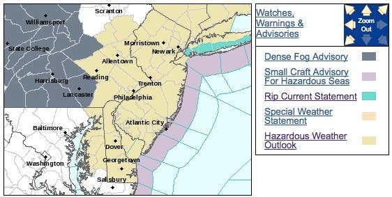
The National Weather Service has issued a hazardous weather outlook, saying Hurricane Jose is forecast to impact New Jersey, eastern Pennsylvania and Delaware by Tuesday. A period of rain, gusty winds, beach erosion, and coastal flooding are all possible, but it's all dependent on the track of the storm.
Find out what's happening in Philadelphiafor free with the latest updates from Patch.
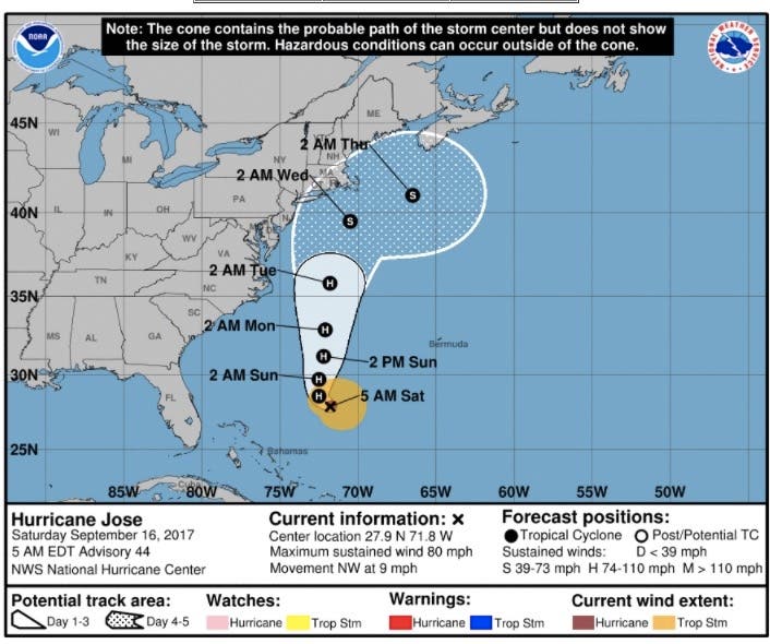
The storm has turned into a category 1 hurricane, with winds moving as fast as 85 mph. If could become the first major storm to have a direct impact on the region since Superstorm Sandy in 2012.
Jose has shifted in the region's direction in recent days, defying earlier predictions that the storm was destined to head out to sea. The National Hurricane Center's Saturday tracking map showed that at least part of the region is within the storm's "cone of uncertainty," although it could pose a greater threat to Long Island and New England.
Find out what's happening in Philadelphiafor free with the latest updates from Patch.
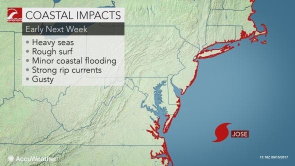
Regardless of where you are, Jose will track close enough to the northeastern United States to raise seas and winds as well as to deliver rain to coastal areas next week, according to AccuWeather. In the days leading up to the storm, rip currents will pose a danger to swimmers.
People in coastal areas of the Northeast will need to monitor the progress of Jose, which will begin to track northward but remain offshore of the Southeastern states this weekend, according to an AccuWeather release.
"It appears that Jose will miss the quick ride away from the U.S. coast and into the cold waters of the North Atlantic next week," AccuWeather Senior Meteorologist Bernie Rayno said in the release.
Winds may get strong enough to damage trees and cause sporadic power outages. Gusts to 50 mph are possible from eastern Maryland to Maine and are likely on Cape Cod, Massachusetts, according to AccuWeather.
Some rain will, at the very least, reach the mid-Atlantic and New England coasts. The combination of rain and wind near the coast will lead to airline delays and slow travel on area highways. Should Jose be stronger than a Category 1 hurricane and/or make landfall, more significant effects are likely. A Category 1 hurricane or the equivalent thereof can cause property damage, widespread power outages, flooding rainfall and moderate coastal flooding, according to AccuWeather.
Here is the weather forecast:
- Saturday: A slight chance of showers and thunderstorms after 2 p.m. Patchy fog before 9 a.m. Otherwise, partly sunny, with a high near 79. Calm wind becoming east 5 to 7 mph in the afternoon. Chance of precipitation is 20%.
- Saturday night: Patchy fog after 1am. Otherwise, partly cloudy, with a low around 65. East wind around 5 mph becoming calm in the evening.
- Sunday: Mostly sunny, with a high near 76. East wind 5 to 9 mph.
- Sunday night: Mostly cloudy, with a low around 63. East wind 6 to 8 mph.
- Monday: A slight chance of showers. Mostly cloudy, with a high near 75. Northeast wind 11 to 15 mph. Chance of precipitation is 20%.
- Monday night: A chance of showers. Mostly cloudy, with a low around 65. Chance of precipitation is 40%. New precipitation amounts of less than a tenth of an inch possible.
- Tuesday: Tropical storm conditions possible. A chance of showers. Mostly cloudy, with a high near 75. Chance of precipitation is 50%.
- Tuesday night: Tropical storm conditions possible. A chance of showers. Mostly cloudy, with a low around 63. Chance of precipitation is 50%.
- Wednesday: A chance of showers. Mostly sunny, with a high near 81. Chance of precipitation is 30%.
NASA photo of Jose
Get more local news delivered straight to your inbox. Sign up for free Patch newsletters and alerts.