Community Corner
UPDATE: 'Massive' Rain, Flooding Threatens Pennsylvania Whether Hurricane Joaquin Comes Or Not
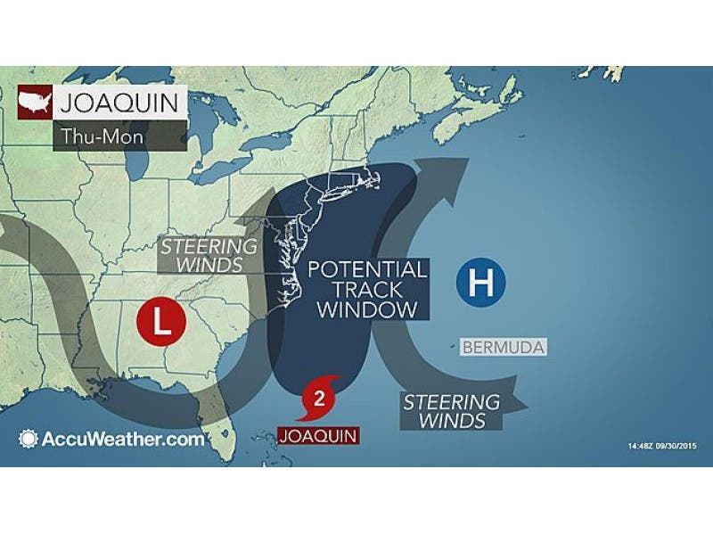
More than five inches of rain could fall as all virtually all models show that Hurricane Joaquin is heading towards region.

By TOM DAVIS and JUSTIN HEINZE
This time may be for real.
What could be the worst storm to hit Pennsylvania since Superstorm Sandy will impact the region - whether the weather system comes here or not.
Find out what's happening in Plymouth-Whitemarshfor free with the latest updates from Patch.
Hurricane Joaquin could have the following impacts:
- The storm could bring pounding surf, dangerous seas, strong winds, drenching squalls and flash flooding to the East Coast and the Bahamas, according to AccuWeather.com.
- Wind gusts could reach between 75 and 100 mph on some of the Bahamas - and even beyond, according to forecasters.
- The Weather Channel described the storm’s potential impact in one word: “massive.”
- All weather models indicate that at least five inches of rain could fall in the area by Monday.
- The National Weather Service has issued a Hazardous Weather Outlook and a Coastal Flood Warning for New Jersey, saying the storm - even it pushes east, and away from the coast - will likely cause flooding problems at the shoreline.
- Rip current, small craft and gale advisories were posted for Thursday as a separate weather system passes through.
- Once Hurricane Joaquin moves north, it will bring with it an elevated risk of rip currents along the coast, and the week’s rain may result in localized flooding in areas of poor drainage.
Gov. Chris Christie, who has been on the presidential campaign trail, did not release a statement on the hurricane. His press office said he may issue one on Thursday.
Find out what's happening in Plymouth-Whitemarshfor free with the latest updates from Patch.
The National Hurricane Center and The Weather Channel said the storm could reach the New Jersey-Pennsylvania region by late Sunday or early Monday morning.
To reach hurricane status, wind speeds needed to hit a sustained 74 miles per hour. They’re now well over 80.
Get updates on the hurricane by signing up for a Patch newsletter - click here for more
With every hour that passes, meteorologists at the National Weather Service seem even more convinced that the hurricane is targeting the area that stretches from New Jersey to North Carolina.
Here is one tweet from the National Weather Service:
Here’s another from a meteorologist at the National Weather Service:
Gary Szatkowski also scoffed at European models that suggest the storm will shift east, saying: “Lot of talk about Euro model regarding #Joaquin forecast track. I remember Euro really nailed a late January snowstorm. Oh wait. It didn’t.”
Local residents should read up on 7 Things Montgomery County Should Know About Hurricanes.
Get more local news delivered straight to your inbox. Sign up for free Patch newsletters and alerts.