Crime & Safety
Controlled Burn At Valley Forge National Park Begins Tuesday
Don't be alarmed if you see smoke in and around Valley Forge National Park, as a controlled burn is planned for the coming days.


Officials will be conducting a controlled burn for a large area of Valley Forge National Park this week, according to federal officials.
The National Park Service said it will conduct the burn Tuesday, April 2 and Wednesday, April 3.
Burns will begin at about 10 a.m. and could last from two days to one week depending on conditions.
Find out what's happening in Tredyffrin-Easttownfor free with the latest updates from Patch.
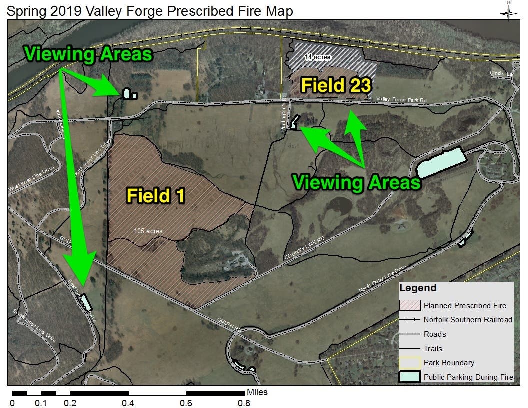
A 135-acre area is the target of the burn. That area is along Valley Forge Road/PA Route 23 and Gulph Road.
The area for the burn is within the Grand Parade area, a high priority habitat area with a diverse mixture of native and non-native plant species that will be assessed following the burn.
Find out what's happening in Tredyffrin-Easttownfor free with the latest updates from Patch.
The public can actually watch the burn if they wish.
Public viewing areas are:
- Varnum’s Picnic Area and Artillery Park
- Portions of Joseph Plumb Martin Trail (Field #1)
- Maurice Stephens House Parking Lot
- Joseph Plumb Martin Trail Along PA Route 23 (Field #23)
Check out maps of the viewing areas below:
Areas of the park will be closed for the burn. Those areas are:
- Field #1
- Von Steuben Statue and Maurice Stephen House Parking Areas
- North Inner Line Drive
- Grand Parade Trail from the North End of Baptist Trace to Maurice Stephens House
- Baptist Trace Trail from Gulph Road to Route 23
- “Underlook Trail” from Baptist Trace to the Grand Parade Trail
- Field #23
- Chapel Parking Lot (NPS portion)
- Chapel Trail
Visitor facilities, trails, and roads will remain open and public viewing areas adjacent to the fire will be available.
Vehicle traffic on PA Route 23 and Gulph Road may experience slight delays due to smoke.
A list of frequently asked questions on controlled burns is available here.
Called "prescribed fires," the burns help with managing invasive plants and promoting native species, especially when used in conjunction with other treatments, according to the NPS
Several national parks in Pennsylvania regularly utilize prescribed fire, including Gettysburg National Military Park and Delaware Water Gap National Recreation Area, the NPS said
Contact NPS Public Information Office Jonathan Parker at Jonathan_Parker@nps.gov or 610-783-1008.
Image via Shutterstock
Get more local news delivered straight to your inbox. Sign up for free Patch newsletters and alerts.