Community Corner
More Snow Coming, Along With 20 Below Zero Wind Chill
In addition to record-breaking cold, forecasters say the region should prepare for another dose of snow Monday night into Tuesday morning.

Just in case you forgot it was winter, Mother Nature would like to remind you again this week.
In addition to record-breaking cold, forecasters say the region should brace for another dose of snow Monday night into Tuesday morning. The National Weather Service has issued a Winter Storm Watch from 6 p.m. Monday until noon on Tuesday.
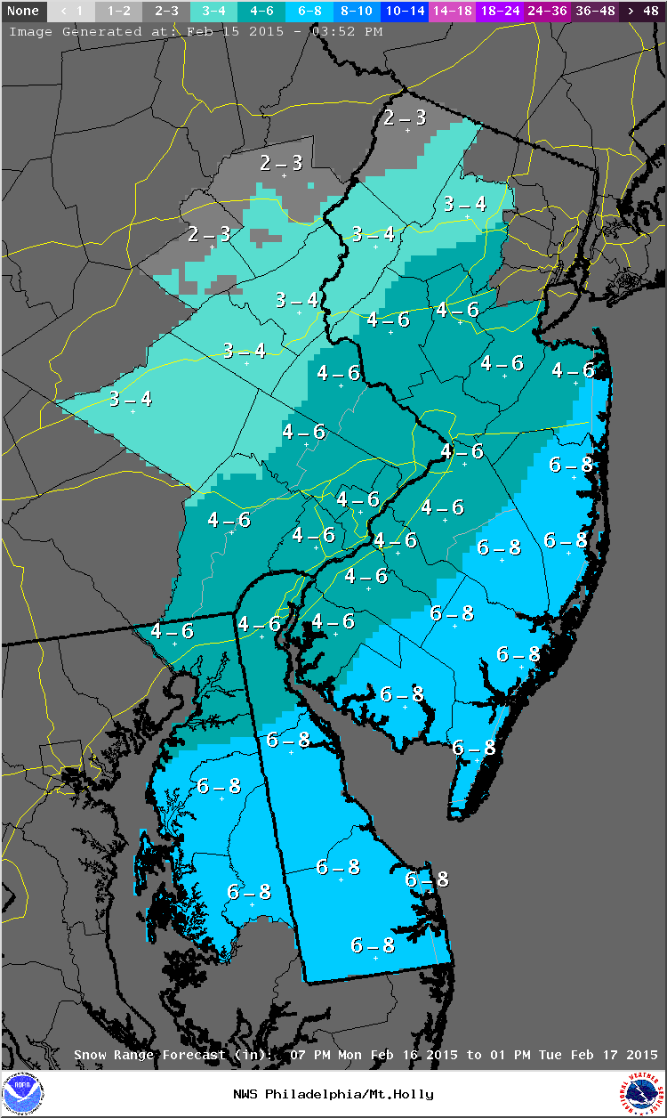
The storm has the potential for significant snow accumulation, according to the NWS. Eastern Pennsylvania and Central New Jersey can expect between 4 and 6 inches, according to estimates as of Sunday night. Coastal areas along New Jersey may see a bit more and North Jersey may see a bit less, according to NWS predictions.
Find out what's happening in Upper Moreland-Willow Grovefor free with the latest updates from Patch.
Snow will likely arrive Monday evening and then taper off Tuesday afternoon, the NWS said. The system may impact Tuesday morning commutes and travel, according to forecasters.
The extreme cold won’t be letting up, either, Wind chill values as low as 15 to 20 degrees below zero are possible overnight Monday into Tuesday, according to the NWS. Lows Monday are expected to be plunge to 2 below zero with wind gusts of around 25 miles per hour.
Find out what's happening in Upper Moreland-Willow Grovefor free with the latest updates from Patch.
Forecasters warn the temperatures are “dangerously” cold and can lead to frostbite and hypothermia. “If you must venture outdoors, make sure to dress in layers and cover exposed skin,” the NWS-issued Winter Storm Watch said.
According to the Weather Channel, temperatures will remain bitter cold throughout the week, with lows on Thursday again plummeting below zero. It looks like a break from the harsh cold may arrive next weekend, when Sunday’s high is forecasted to be in the low 40s.
RELATED
- Accidents, Power Outages, 60-mph Winds, Worst Cold Since 2004 Slam Pennsylvania
- How to Keep Warm During the ‘Polar Plunge’
- How to Protect Your Pipes as Record-Breaking Cold Approaches
(Photo: National Weather Service snow predictions map)
Get more local news delivered straight to your inbox. Sign up for free Patch newsletters and alerts.