Community Corner
Record Cold, More Weekend Snow Headed Our Way
A blast of dangerously-cold air is heading our way Thursday, and will likely be followed by another round of weekend snow.

A blast of arctic air will arrive “in full force” Thursday and linger through Friday, creating the potential for record-breaking cold and paving the way for another round of possible weekend snow, according to forecasters.
The bitter shot of freezing air has the potential to make conditions even colder than the last artic outbreak the region experienced earlier this week, forecasters from the National Weather Service warn.
The cold, along with the brisk winds, has prompted a wind chill advisory that begins Thursday evening and goes through Friday morning.
Find out what's happening in Upper Moreland-Willow Grovefor free with the latest updates from Patch.
It could feel as cold as 10 to 15 degrees below zero with the wind chill, according to estimates from the NWS. Gusts could be as strong as 32 miles per hour in Eastern Pennsylvania, the NWS said.
The entire region will be impacted by the cold, which will invade Pennsylvania, New Jersey, Delaware and beyond. Even states as far south as Florida are experiencing record lows, the Weather Channel said.
Find out what's happening in Upper Moreland-Willow Grovefor free with the latest updates from Patch.
Forecasters warn the cold could be dangerous. Frostbite and hypothermia are likely if people venture outdoors without proper precautions. The cold weather has already been deadly in Pennslyvania. There have been three deaths in Montgomery County in the past month due to the cold temperatures.
Plus, water pipes that are near freezing will likely “freeze solid” tonight and damage will develop as they thaw, the National Weather Service Warns. Click here for tips to prevent and deal with frozen pipes.
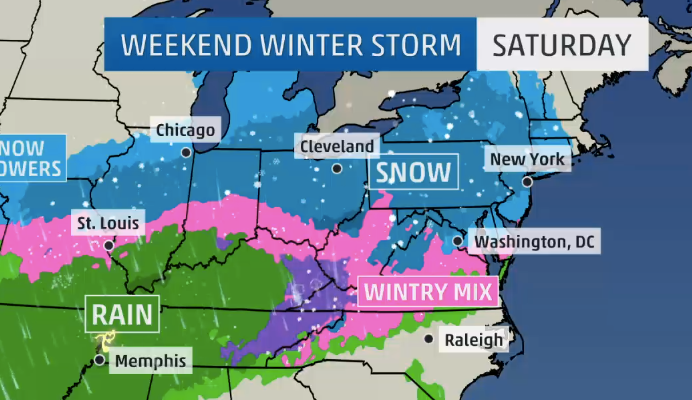
The shot of freezing air is just one element of winter weather forecasters are presently tracking. The Weather Channel is watching another winter storm likely to arrive by the weekend that has the potential to drop more snow and sleet on the region.
Currently, forecasters estimate snow will arrive Saturday evening and accumulate before precipitation switches over to rain on Sunday.
Here is the current forecast, according to National Weather Service:
Thursday night: Partly cloudy, with a low around -1. Wind chill values as low as -16. West wind 14 to 16 mph becoming northeast after midnight. Winds could gust as high as 32 mph.
Friday: Sunny, with a high near 12. Wind chill values as low as -18. West wind 11 to 16 mph.
Friday night: Partly cloudy, with a low around 3. Wind chill values as low as -5.
Saturday: A chance of snow after 1pm. Mostly cloudy, with a high near 33. Chance of precipitation is 40 percent. New snow accumulation of less than a half inch possible.
Saturday night: Snow before 11pm, then snow and sleet between 11pm and midnight, then rain and snow after midnight. Low around 33. Chance of precipitation is 80 percent. New precipitation amounts between a quarter and half of an inch possible.
Sunday: Rain. High near 42. Chance of precipitation is 80 percent.
Get more local news delivered straight to your inbox. Sign up for free Patch newsletters and alerts.