Community Corner
Winter Storm to Bring Snow, Strong Winds, Sub-Zero Temps To Pennsylvania
The NWS has issued four alerts, warning of 20-below wind-chill temps, 3-5 inches of snow, 60-mph winds, power outages and property damage.

The impact of Winter Storm Neptune will begin Saturday, and it will be very cold, and very windy.
Forecasters say 60-mph gusts could lead to power outages and property damage.
The National Weather Service has issued a “Winter Weather Advisory” for the weekend, saying 3 to 5 inches could fall across eastern Pennsylvania and make roads very slick.
Find out what's happening in Upper Moreland-Willow Grovefor free with the latest updates from Patch.
Blowing snow may reduce visibility to one-quarter mile or less at times.
The NWS also has issued a “High Wind Advisory” and a Wind Chill Advisory for Sunday and Monday, saying wind chill temperatures will be as as low as 20-below in some areas, while winds will move 20 to 30 mph, with tropical-storm-force gusts of up to 60 mph.
Find out what's happening in Upper Moreland-Willow Grovefor free with the latest updates from Patch.
“A Winter Weather Advisory means that periods of snow will cause travel difficulties,” the National Weather Service said. ”Be prepared for slippery roads... limited visibilities... and blowing snow. Use caution while driving.”
A Wind Chill Advisory means that very cold air and strong winds will combine to generate low wind chills, resulting in possible frost bite and lead to hypothermia if precautions are not taken, according to the National Weather Service.
What else should we expect:
- A High Wind Warning will be in effect from 10 p.m. Saturday evening to 2 pm Sunday.
- The highest winds should occur between 5 a.m. and noon Sunday.
- Be prepared for power outages possibly lasting for more than 24 hours. trees and tree limbs could be knocked down.
- Minor structural damage to homes is possible.
- Do not park vehicles where trees can fall on them.
- Make sure all cell phone and electronic devices are fully charged.
- If you have a generator, make sure it is working properly and is properly ventilated when in use.
- Expect bridge restrictions and impacts to high-profile vehicles.
A ”High Wind Warning means a hazardous high-wind event is expected or occurring. Sustained wind speeds of at least 40 mph or gusts of 58 mph or more can lead to property damage, the National Weather Service says.
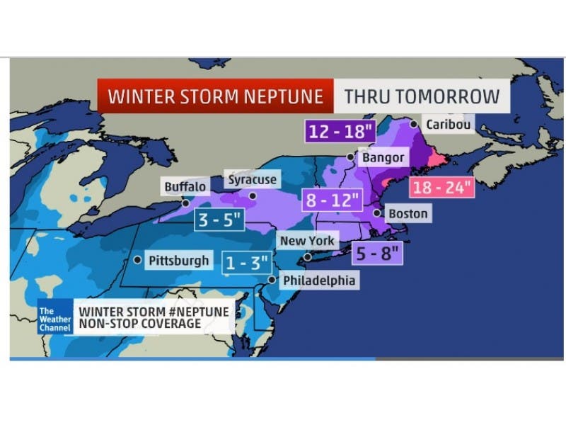
The Weather Channel says the New York City and Philadelphia areas will have moderate snow and strong winds, which could lead to near blizzard conditions in those areas despite much lighter snowfall than New England.
Winter Storm Neptune’s impact will be magnified by a large field of strong winds, even in areas outside the heaviest snow, and a sharp drop in temperatures that will lead to dangerously low wind chills, The Weather Channel says.
Get more local news delivered straight to your inbox. Sign up for free Patch newsletters and alerts.