Weather
Bomb Cyclone Storm Threatens RI With 60+ MPH Winds, Blizzard Conditions: Latest Forecast
A very powerful ocean storm will likely bring hazardous and damaging conditions to coastal locations this weekend.

A powerful "bomb cyclone" storm off the Atlantic coast could bring blizzard conditions to parts of Rhode Island this weekend with winds of more than 60 mph, heavy snow, erosion and flooding potential amid astronomical high tides.
"Strong winds and rising seas will push water onshore from North Carolina to New England, producing coastal flooding and beach erosion," AccuWeather Senior Meteorologist Scott Homan said. "With a full moon this weekend, astronomical tides will be higher than normal. That means even a modest storm surge can push water much farther inland than people expect.
"Coastal residents need to be prepared for flooding near high tide."
Find out what's happening in Across Rhode Islandfor free with the latest updates from Patch.
AccuWeather said water levels could surge 2 to 4 feet above normal at high tide in coastal parts of New Jersey, North Carolina's Outer Banks and New England.
Related: Frigid Rhode Island Temperatures Tonight And Tomorrow Night Followed Buy More Snow
Find out what's happening in Across Rhode Islandfor free with the latest updates from Patch.
The storm is forecast to rapidly intensify into a "bomb cyclone" along the southern Atlantic coast on Saturday, with atmospheric pressure plunging at least 24 millibars in 24 hours or less.
AccuWeather experts say more than 5,000 flights could be cancelled across the country Saturday through Monday.
"Blizzard conditions may reach parts of Long Island and southern New England," Homan said.
See also: Huge South American Lizard Found By Providence Man Shoveling Driveway
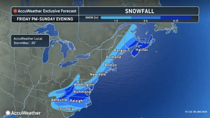
The relentless stretch of arctic air all but ensures that any precipitation that falls will be in the form of snow.
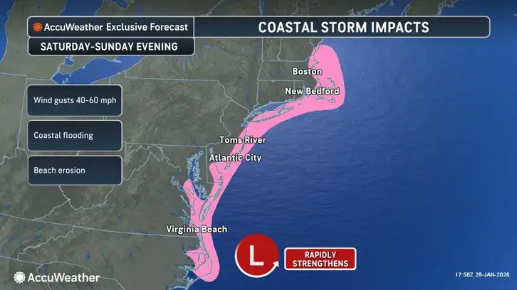
AccuWeather said the blizzard conditions are possible at times late Saturday through Sunday across parts of coastal New England and Long Island.
Prior to the storm, a Cold Weather Advisory is in place for Rhode Island from 7 p.m. Thursday night through 11 a.m. on Friday. Wind chills could reach 20 degrees below zero with low temperatures near zero overnight.
See also: Rhode Island Workers Lose $3.8B to Mental Health And Substance Use Issues Over 5 Years: Survey
"The dangerously cold wind chills as low as 20 below zero could result in hypothermia or frostbite if precautions are not taken," AccuWeather warned.
"Use caution while traveling outside. Wear appropriate clothing, a hat, and gloves," according to the advisory.
Thursday night's low temperature will be a mere 2 degrees and Friday night will be even worse at only 1 degree, according to the National Weather Service forecast.
See also: The Nature Conservancy Acquires 105 Acres Of West Greenwich Forest
A mostly sunny Saturday warms up to 21 degrees, the National Weather Service predicts, but Saturday night the mercury plunges back down to 11 degrees as more snow starts to fall.
Even more snow is likely Sunday but the temperature climbs to 25 degrees with blustery winds blowing 16 to 20 mph and gusting up to 38 mph.
There is a chance of more snow Sunday night as the temperature drops back down to 16 degrees.
See also: The Nature Conservancy Acquires 105 Acres Of West Greenwich Forest
Get more local news delivered straight to your inbox. Sign up for free Patch newsletters and alerts.