Weather
After above-normal temperatures last few days, feel of autumn comes for the weekend.
A cold front Friday night will not only bring showers, but a change in temperatures. Sweater weather comes on Saturday, and stays next week.

Weather Forecast Discussion for Rhode Island on September 23, 2016
Happy autumnal equinox, everyone! At 10:21 a.m. this morning, we said good-bye to summer, and entered the fall season. However, based on high temperatures, it still feels like summer. The above-normal temperatures will remain into Friday, before a cold front changes our weather Friday night, and our temperatures for this weekend.
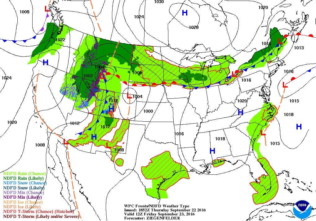
High pressure over eastern Pennsylvania will slowly move out to sea tonight. We will keep clear skies, and temperatures will fall into the upper 50’s. With dewpoints in the same range, there may be some patchy fog, especially late in the night. We will keep sunshine in the morning, with increasing clouds through the afternoon. The cloud cover is due to a cold front approaching from the northwest. Temperatures will reach the lower 80’s by the afternoon. By Friday night, the front will pass, with scattered showers by the end of the evening commute. With the warmer temperatures, an isolated thunderstorm is possible. Showers will end by 4 a.m., as high pressure ridging from the west begins to build in. Skies will clear through Saturday morning. Look for low temperatures to fall into the middle 50’s.
Find out what's happening in East Providencefor free with the latest updates from Patch.
On Saturday, the air will feel crisper, and temperatures will definitely tell you we have a touch of autumn. With high pressure at the lower levels of the atmosphere, an upper-level trough will help bring some cooler air from the Yukon. You can keep the sweater on through the day, as high temperatures only reach the upper 60’s. We will keep clear skies for Saturday night, and you may want to keep the windows closed. Temperatures will fall into the upper 40’s. Some isolated areas may even see temperatures fall into the upper 30’s, as dewpoint temperatures drop as well. It will be beautiful to throw the football around on Sunday, as we expect sunny skies and high temperatures in the middle 60’s. Clear skies stick around for Sunday night, and temperatures will fall into the middle 40’s.
We continue to have sunny and dry weather entering Monday, as high pressure moves right over Southern New England. However, the computer models go in completely different directions after Monday afternoon. According to the European and United Kingdom models, the high pressure system that has stayed over our area moves out faster, allowing for a low pressure system in the Great Lakes to move east. The frontal boundary reaches our area by Monday night, giving us showers into Tuesday morning. I also looked at the Canadian model, and it keeps the high right over New England Monday and Tuesday. For now, I cannot see how that high gets “pushed” out so quickly by the other models. So, I will keep us dry for Monday night right through Tuesday night. Look for clear skies Monday night with lows in the upper 40’s. Sunny skies will be abundant Tuesday, with highs slowly reaching 70. With south winds, we should see partly cloudy skies Tuesday night, with lows staying in the lower 50’s.
Find out what's happening in East Providencefor free with the latest updates from Patch.
The strong high will slowly move off to the north and east, giving us partly cloudy skies for Wednesday. We can expect high temperatures in the lower 70’s. We remain under the influence of a high pressure ridge Wednesday night, but south winds will allow for more moisture to come into Southern New England. This will make our low temperatures mild, as the mercury only falls into the middle 50’s. By next Thursday, a weakening cold front may bring the risk for some showers, especially by the evening. So, the day will be partly sunny, with high temperatures near 70.
Tropical Update: Since the last update, Ian and Julia has dissipated. Now, we have two named storms in the Atlantic. Tropical Depression Karl was centered 505 miles south-southeast of Bermuda as of 2 p.m. EDT. It only has maximum wind speeds of 35 mph, and is moving northwest at 16 mph. The system is forecast to slowly strengthen over the next 36 hours. A Tropical Storm Watch is in effect for Bermuda, as the island may be grazed by the western edge of the tropical-storm-force wind field within the next 36 to 48 hours.
Also, Tropical Storm Lisa is centered 710 miles west-northwest of the Cabo Verde Islands as of 11 a.m. EST. Maximum sustained winds are at 50 mph, and is moving northwest at 7 mph. Fortunately, Lisa will be entering an area of increasing wind shear, helping to weaken the system. Within 72 hours, Lisa will weaken to a post-tropical system or remnant low.
Jim Laurie is a local meteorologist who earned a B.S. in Meteorology at Lyndon State College in Lyndonville, VT. Jim has fifteen years of professional experience, with eight years in the field of marine meteorology.


