Weather
Best weather in country continues into Wednesday; showers/thunderstorms possible Wednesday night; cooler weather by Thursday
We are still seeing above-normal temperatures for the end of August. Some autumn like temperatures will arrive by Thursday.

Weather Forecast Discussion for Rhode Island on August 29, 2016
You could have not asked for a better week of weather. The Ocean State received abundant sunshine through the weekend, with high temperatures between the upper 80’s to lower 90’s. It has been quite dry, and the temperatures were well above-normal for this time in August. However, some cooler temperatures can be seen in the seven day forecast.
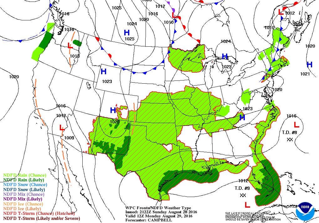
At the moment, a weak cold front is passing through western New York. Widely isolated showers and thunderstorms are developing ahead of the front, and moving east. We will see partly cloudy skies this evening, with lows in the middle 60’s. Except for a passing sprinkle or shower in the morning, we will continue to see mostly sunny skies and hot temperatures, with highs reaching 90. This is not a great start for many kids, as they return to school. A strong high pressure system will bring clear to partly cloudy skies Monday night, with lows in the lower 60’s. Thanks to the winds coming from the north on Tuesday, we will see lower high temperatures, with the mercury only reaching the lower 80’s. We will keep clear skies Tuesday night, with lows in the middle 60’s. The low temperature will be warmer as winds shift back to the south and southwest, allowing for the dewpoint temperature to slowly rise back into the lower 60’s.
Find out what's happening in East Providencefor free with the latest updates from Patch.
We will start Wednesday off with sunny skies, but a cold front approaching will bring some high and mid-level clouds by the afternoon. Skies will become overcast by the evening commute. We should see enough sunshine to have high temperatures reach the middle 80’s. We will see the chance for some passing showers and isolated thunderstorms into Wednesday night, with lows only in the upper 60’s. We will start Thursday with the risk for passing showers, as the cold front stalls before moving offshore in the afternoon. Any shower activity will end by 1 p.m., with partial sunshine before sunset. Due to the cloud cover, high temperatures will only reach near 80 degrees. High pressure coming down from central Canada will bring back clear skies by Thursday night. With lighter winds and lower dewpoint temperatures, the lows will fall into the lower 60’s.
By Friday, that strong high will control our weather pattern right into next Sunday. Also, an upper level trough over the eastern U.S. will bring us some autumn like weather. We keep sunny skies for Friday and Saturday, with high temperatures in the upper 70’s. We can open up our windows during the evenings, as lows will fall into the middle to upper 50’s. By Sunday, the upper level trough moved east, allowing for a weak upper level ridge to take over. This will help increase our high temperatures on Sunday, as the mercury reaches the lower 80’s. Looking ahead to Labor Day and finishing off the holiday weekend, it appears the high will protect us from one of the tropical systems, leaving us with mostly sunny skies. Look for highs in the lower to middle 80’s.
Find out what's happening in East Providencefor free with the latest updates from Patch.
Meanwhile, the Atlantic tropical season is really starting to pick up. We now have three named tropical systems, although we only have one named storm. We will begin with Hurricane Gaston. As of 5 p.m. Sunday, Gaston was centered about 580 miles east of Bermuda, with maximum sustained winds of 115 mph. The system is forecast to stop moving northwest and begin moving north. By Monday, it will begin to move towards the northeast, before trying to get into the cold front that will pass us tomorrow morning. The storm will simply move away from any land near the east coast by midweek. However, New England will see strong swells from this storm make its way towards our beaches starting by tonight. It will continue into Tuesday evening.
Also, we have two tropical depressions at different stages. Tropical Depression Eight was started at 11 a.m. Sunday. Eight is centered 355 miles southeast of Cape Hatteras, North Carolina as of 5 p.m. Maximum sustained winds are only 35 mph, and moving west at 9 mph. The system is forecast to continue moving west-northwest to northwest towards North Carolina into Tuesday afternoon. Then, due to the system looking to move towards lower pressure, the weak cold front passing through Monday will give Eight the steering motion it needs to move away from the U.S. coastline. Some rain may fall along the Outer Banks, but the system will not make landfall. It will then track northeast Tuesday night into Wednesday afternoon.
Finally, the one system that I have been describing in previous discussions became Tropical Depression Nine at 5 p.m. Sunday. Nine was centered 55 miles northeast of Havana, Cuba and has maximum sustained winds of 35 mph. The system is forecast to move west to west northwest over the next three days. It reaches the eastern Gulf of Mexico as a tropical storm. By Wednesday afternoon, the system will begin to track northeast to east-northeast, as it gets caught up moving with a cold front. It will make landfall over northwest Florida late Thursday night, before coming back out on the Atlantic side Friday afternoon.
Jim Laurie is a local meteorologist who earned a B.S. in Meteorology at Lyndon State College in Lyndonville, VT. Jim has fifteen years of professional experience, with eight years in the field of marine meteorology.


