Weather
Drizzle, Showers and Gusty Winds Expected Thursday
Dry and cooler weather can be expected for the weekend. Also, a look at Hurricane Nicole.

Weather Forecast Discussion for Rhode Island on October 13, 2016
We have had dry and cooler weather since the last forecast discussion here in the Ocean State. Temperatures have rebounded last night into the lower 40’s, after seeing early Columbus Day see temperatures in some spots fall into the middle to upper 30’s. The mildest day of the week will be Thursday, before temperatures once again become cooler for a brief period of time.
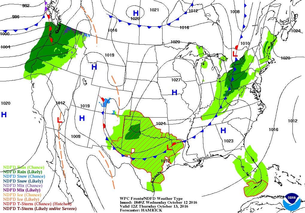
At the moment, high pressure off of Newfoundland is bringing a strong high pressure ridge across the eastern U.S. The ridge will begin to break down tonight, as moisture in the lower levels of the atmosphere moves over the region. That means we will see increasing clouds tonight, with the risk of patchy fog and some drizzle before 4 a.m. Temperatures will only fall into the lower 50’s. On Thursday, expect patchy drizzle and passing showers in the morning, with scattered showers by mid-afternoon. This is due to an approaching cold front, which will not move over the state until 7 p.m. High temperatures will reach the upper 60’s, before winds turn to the north. We will see some leftover showers end by midnight, with clearing skies during the overnight. You might hear some gusty winds if you’re a light sleeper, as high pressure builds in behind the cold front. Low temperatures Thursday night will fall into the upper 40’s.
Find out what's happening in East Providencefor free with the latest updates from Patch.
The high pressure system will slowly stay over New England through the weekend. We will still have some breezy north winds on Friday, with highs only reaching 60. Skies will be clear Friday night, with low temperatures near Providence falling into the lower 40’s. Cities and towns north and west of Providence will probably see temperatures in the middle to upper 30’s. It remains sunny and cool for Saturday, with highs struggling to reach 60. Saturday night may be our coldest night yet, as Providence is expected to see temperatures in the middle 30’s. This means north and west of Providence will likely be below freezing, with some lows falling into the upper 20’s. You may want to bring in any plants still growing, or put tarps over any plants still in the ground. We will see sunshine on Sunday morning, with some mid-level clouds by the late afternoon. High temperatures will reach the lower 60’s, with lows Sunday night in the upper 40’s due to overcast skies.
We enter a new school and work week Monday with an approaching cold front. The European model is slightly different, showing a low pressure system moving into western New York by 8 a.m. Monday morning. To me, I feel the American model does not have a good handle on the upper level dynamics. So, I will say a low pressure system reaches over New England, bringing some scattered showers. The showers should end by 7 p.m. High temperatures will reach the middle 60’s. We will see partial clearing Monday night, as we await weak high pressure ridging from the northwest to move over our area. Low temperatures will fall into the lower 50’s. We will return to sunshine on Tuesday, with highs in the upper 60’s. Overcast skies will take over Tuesday night, as moisture ahead of a low pressure system in the Great Lakes moves overhead. Low temperatures will fall into the middle 50’s. We will see partly sunny skies next Wednesday, although the models do not agree on the positioning and strength of that low pressure system. For now, I will call for a chance for showers, especially by the early evening hours. But, my overall confidence in the models after Tuesday is very low. Look for high temperatures next Wednesday to be in the middle 60’s.
Find out what's happening in East Providencefor free with the latest updates from Patch.
Tropical Update: Hurricane Nicole has strengthened since the last weather discussion. With maximum sustained winds of 100 mph as of 2 p.m. Wednesday, she is centered about 270 miles south-southwest of Bermuda. Currently, she is moving north at 8 mph. A Hurricane Warning is in effect for Bermuda, with the forecast strengthening Nicole slightly over the next 12 hours. Unfortunately, the forecast track has the center moving right over the island between 10 a.m. and noon Thursday. Increasing shear and cooler water temperatures will weaken Nicole after 72 hours, and will become a post-tropical cyclone within 96 hours.
Southeast U.S. Update: The main state still facing problems is North Carolina. With between 6 to as much as 18 inches of rain on Sunday, many rivers have still not reached their crest, despite being well over their limits. The Tar River in Greenville, North Carolina may reach the second highest crest ever recorded. By the end of the week, the river could reach between 25 to 26 feet. The water may begin to flood the Pitt-Greenville Airport, and also reach the city of Greenville. Roads may become impassable. For those wandering what roads are open and closed in the hardest hit areas in several states, I will send you to a news article with that information here.
Jim Laurie is a local meteorologist who earned a B.S. in Meteorology at Lyndon State College in Lyndonville, VT. Jim has fifteen years of professional experience, with eight years in the field of marine meteorology.


