Weather
Good weather will last through the week; warmer temperatures expected each day; eastern U.S. now watching Hurricane Matthew
High pressure will remain over New England into the end of the week. But, Matthew keeps uncertainity for the eastern U.S. this weekend.


Weather Forecast Discussion for Rhode Island on October 5, 2016
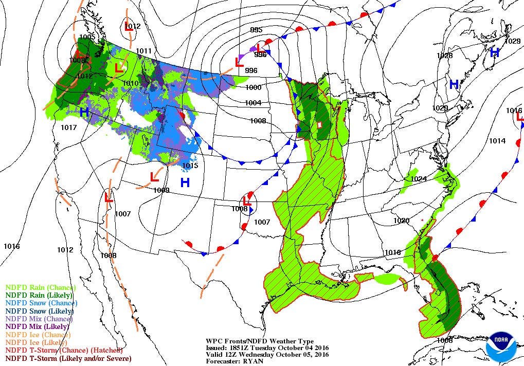
After some morning clouds and widely isolated showers, high pressure ridging from the northeast is giving the Ocean State sunny skies. However, the daytime heating is helping to create strong northeast winds, blowing at 15-20 mph. As we move into this evening, the winds will diminish. We will have dry and sunny weather into the end of the week. However, all eyes are on Haiti right now, as Hurricane Matthew is forecast to begin affecting the eastern U.S. by Thursday night. And, depending on the track, Southern New England will feel the effects from this system.
At the moment, we are seeing sunny skies, and we will stay clear to partly cloudy this evening. Low temperatures are expected to fall into the upper 40’s. We will keep mostly sunny skies for Wednesday, with highs in the middle 60’s. The good weather continues Wednesday night, with clear skies and lows in the upper 40’s. A high pressure center over the Mid-Atlantic continues the nice weather Thursday and Friday, with highs in the lower 70’s, and lows in the upper 40’s to near 50 degrees. Due to the increasing dewpoint temperatures, there is the risk for some patchy fog Thursday and Friday night.
Find out what's happening in East Providencefor free with the latest updates from Patch.
As we go into Saturday, the weather forecast becomes more uncertain. The American model believes the high pressure center will move further out to sea, weakening the high pressure ridge. This will allow Matthew to move up along the east coast. At this time, the National Hurricane Center believes Matthew will dart along eastern Florida, before moving its way towards the Carolinas. Matthew will actually make landfall near Cape Fear in North Carolina around 8 a.m. Saturday. The system moves west of the Outer Banks and back out into the Mid-Atlantic area. By 8 a.m. Sunday, Matthew is centered about 150 miles south of Long Island. Using the same track, Matthew may pass over Matthew’s Vineyard and parts of Cape Cod by Sunday evening.
So, what does this all mean for us, if the scenario does not change? Well, we would begin to see high surf and strong rip currents by Thursday night or Friday. We will remain dry through most of the daylight hours on Saturday, with partly sunny skies and highs in the low 70’s. We would see the risk for rain, not from Matthew, but from a cold front working its way into Southern New England, around 8 p.m. We would see heavier rain through Sunday, as Matthew passes to our south. We could see several inches of rain from Matthew, which would help put a big dent in our drought conditions. Low temperatures Saturday night will be in the upper 50’s, with highs on Sunday in the middle 60’s.
Find out what's happening in East Providencefor free with the latest updates from Patch.
High pressure over Ohio will bring drier air in by Sunday night, giving us partly cloudy skies and lows in the upper 40’s. It will be sunny for Columbus Day and next Tuesday, with highs near 60 and lows in the middle 40’s. I’ll have a new forecast discussion written by Wednesday afternoon.
Tropical Update: So far, Hurricane Matthew has contributed to eight deaths, including two in Haiti, according to the Weather Channel. They also report Matthew has destroyed homes, ruined crops, flooded towns, and has had livestock washed away. As of 2 p.m., Matthew was centered about 65 miles east-southeast of Guantanamo, Cuba. Maximum sustained winds are at 145 mph, making it a category 4 hurricane. Matthew is moving north at 10 mph. The forecast track has Matthew moving through the middle of the Bahama Islands by 8 a.m. Thursday. Matthew would then be along the east coast of Florida by 2 a.m. Friday morning. It will make landfall around Cape Fear, North Carolina Saturday morning. Matthew will weaken slightly, but we may still have winds of 90 mph at the center when it reaches the Mid-Atlantic region Saturday night. Everyone in Southern New England should begin to make come contingency plans by Friday if Matthew’s track remains the same.
Jim Laurie is a local meteorologist who earned a B.S. in Meteorology at Lyndon State College in Lyndonville, VT. Jim has fifteen years of professional experience, with eight years in the field of marine meteorology.


