Weather
Gray skies ahead, as stalled front stays south of Rhode Island; return to sunshine and summer temperatures by end of week
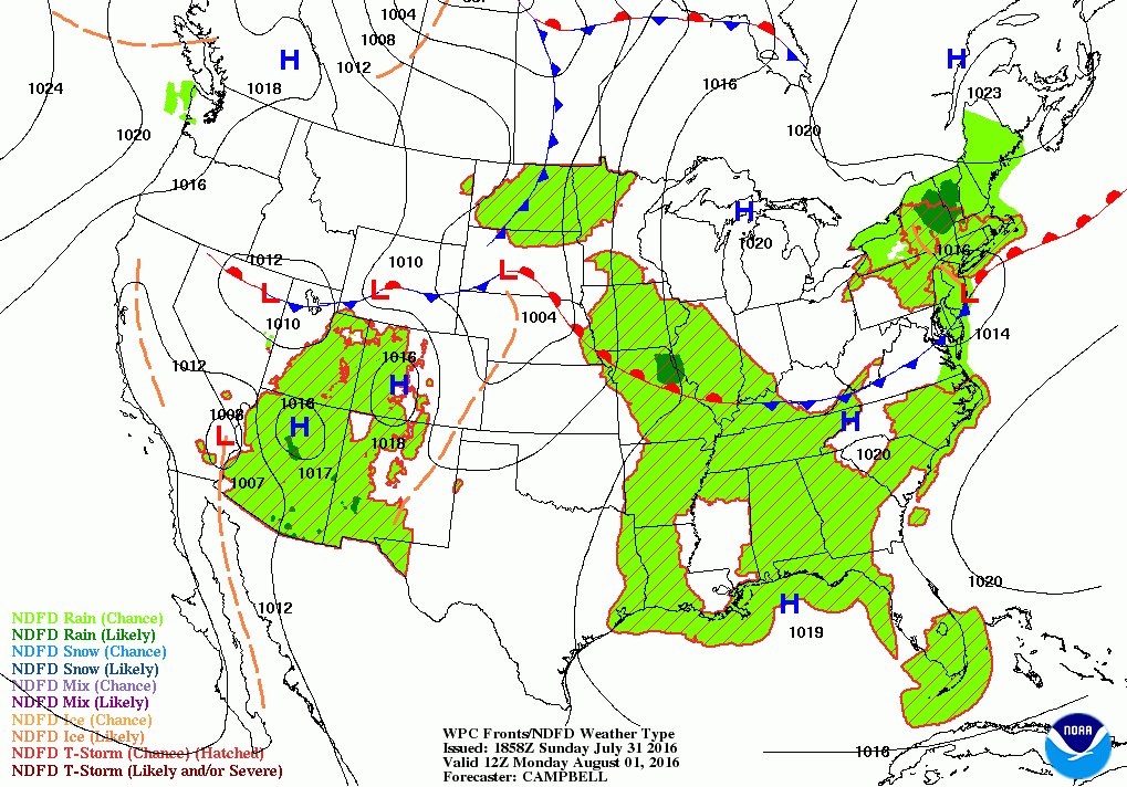
A low over New Jersey will keep the passing chance for showers and cooler temperatures into Tuesday. Warmer weather returns by Thursday.

Weather Forecast Discussion for Rhode Island on August 1, 2016
After forecasting heavy rains Friday, only the south shore received an inch of rain. Otherwise, the front only brought 0.13 inches to central Rhode Island. We remained cloudy on Saturday, with clouds breaking up by the early afternoon. But, low clouds returned for Sunday, with a passing shower. Now, some sunshine has returned to the northern part of Rhode Island. We will return to cloudy skies and possible showers through the early week, with dry skies and warmer temperatures by midweek.
High pressure to the north will give way to a low pressure system over New Jersey. This low will bring the risk for more showers between 8 and 9 p.m. We will see isolated showers the rest of the evening. Low temperatures will only fall into the upper 60’s. By Monday, we will keep the threat of showers in the forecast, but they will be widely isolated. Expect overcast skies with highs in the upper 70’s. The frontal boundary will remain south of us, but another low may form along it Monday evening. This will keep the threat for showers and patchy fog lingering into Tuesday morning. Overnight lows Monday night will be in the middle 60’s. The cooler temperatures are due to the overcast skies, along with winds coming from the north-northeast to east-northeast, which comes off the cooler waters. High pressure over Northern New England will eventually move south, allowing for drier air to come back over the Ocean State. We will keep just overcast skies by the mid-afternoon. High temperatures Tuesday are forecast to be in the upper 70’s, but with any afternoon sunshine, expect the mercury to reach the lower 80’s. Skies will become partly cloudy by Tuesday night, with lows in the lower 60’s.
Find out what's happening in East Providencefor free with the latest updates from Patch.
With the low now out into the Atlantic, high pressure will linger right off of Cape Cod for Wednesday. We will still keep the easterly winds, so expect sunny skies and high temperatures only in the lower 80’s. It will be a little warmer Wednesday night, under partly cloudy skies, as winds begin to turn back to the south-southwest. Low temperatures are forecast to be in the middle 60’s. The high will move slightly more east on Thursday, but will continue to give us mostly sunny skies. High temperatures are forecast to reach the middle 80’s. Dewpoints will also increase by Thursday night, making for partly cloudy skies and muggy conditions, with lows only in the upper 60’s.
As we enter Friday, we will begin to lose the influence of the high, as it moves out into the Atlantic. This will allow a low pressure system over north-central Canada to swing a cold front eastward. We will keep partly to mostly sunny conditions through the daytime hours, with highs in the middle to upper 80’s. Increasing clouds is expected after midnight, with showers arriving before sunrise Saturday morning. Overnight lows Friday evening will be in the lower 70’s.
Find out what's happening in East Providencefor free with the latest updates from Patch.
We should see scattered rain showers through Saturday morning, and ending between 6 and 7 p.m. We may even see partial sunshine before sunset. I will call for highs in the lower 80’s, but if we do see sunshine in the late afternoon, highs could increase into the middle 80’s. Skies will become partly cloudy Saturday evening, with lows in the upper 60’s. High pressure ridging will bring back sunny skies to round out the weekly forecast, with highs in the middle 80’s.
Jim Laurie is a local meteorologist who earned a B.S. in Meteorology at Lyndon State College in Lyndonville, VT. Jim has fifteen years of professional experience, with eight years in the field of marine meteorology.


