Weather
Heavy rain expected for south coast Friday morning; Flash Flood Watch for Friday; Showers possible through the weekend
We will see heavy rain move through Friday morning, but a stalled low may bring scattered showers through the weekend and into Monday.

Weather Forecast Discussion for Rhode Island on July 29, 2016
Since the last discussion, Rhode Island had its second heat wave of the summer season. We had 4 straight days where the temperatures went above 90 degrees, before ending today, when T.F. Green Airport reached a high of 87. Two systems will bring some much needed rainfall to the Ocean state over the next few days. By early next week, we will return to the warm summer conditions.
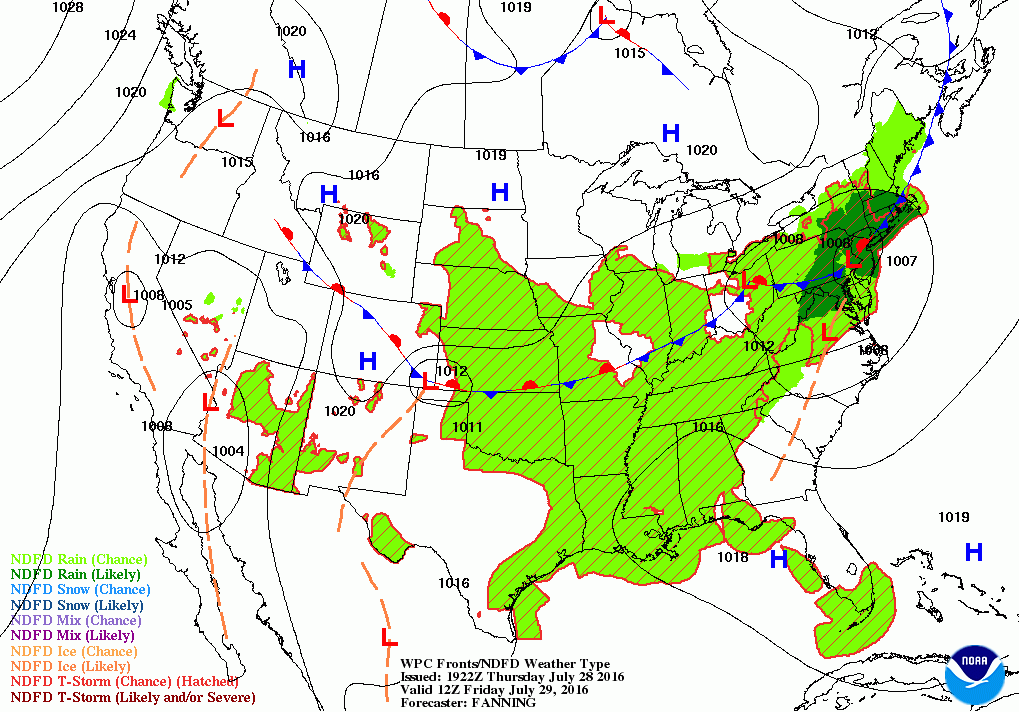
At the moment, we are between two different systems creating thunderstorms and flooding. A cold front over Northern New England is creating scattered thunderstorms. Meanwhile, a low pressure system moving over central Pennsylvania is creating showers, thunderstorms, and heavy rainfall. The two systems will come together by early Friday morning. So, we will see patchy fog tonight, with a few isolated showers before sunrise. Low temperatures will only fall to near 70 degrees. The low will slowly move northeast along the frontal boundary, bringing some possible heavy rainfall, especially to the south coast. This will occur between 6 and 8 a.m., during the worst time of the morning commute. There may be localized street flooding, as 2-4 inches is possible before tomorrow evening. A Flash Flood Watch is in effect for all of Rhode Island from 5 a.m. until 9 p.m. tomorrow night. The low’s center will stay south of the state, but pass just to our south and east by the afternoon. There may be patchy fog during the late morning and early afternoon, especially along the coast. Temperatures will not be that warm, thanks to the cold front passing south. Expect high temperatures only in the upper 70’s. Rain will taper off to showers by the early afternoon, before all precipitation ends by the evening. Skies will begin to clear after midnight. Low temperatures are expected to fall into the middle 60’s.
Find out what's happening in East Providencefor free with the latest updates from Patch.
Now with all the possible rainfall to help revitalize our grass, the weather looks great on Saturday to mow it. A weak area of high pressure will give us mostly sunny skies, with temperatures rising quickly into the upper 80’s. We will see mostly cloudy skies by Saturday night, as moisture to our south from a new low pressure system over the Carolinas helps create these clouds. We may even see some scattered showers and thunderstorms early Sunday morning. Low temperatures will climb back into the upper 60’s. That low may move northeast on Sunday, providing us with isolated showers through the day. I would not call Sunday a washout, but it will be mostly cloudy, with high temperatures in the upper 70’s. If high pressure to our north can push back south, and suppress the moisture south, we will only see mostly cloudy skies Sunday night into Monday. For now, there is the slight risk for more passing showers into Monday. Overnight lows Sunday night will be in the upper 60’s.
By Monday, the low will slowly push out of the Carolinas and into the Atlantic. If the high pressure ridge is too weak, we may continue to see isolated showers through the day, before ending in the early evening. High temperatures will once again be cooler, reaching the upper 70’s. Weak high pressure ridging will move overhead by Tuesday morning. But, we will keep mostly cloudy skies Monday night with lows in the middle 60’s.
Find out what's happening in East Providencefor free with the latest updates from Patch.
With high pressure over Southern New England, we will return to mostly sunny skies for Tuesday, and highs will be comfortable, reaching the lower 80’s. An upper level ridge forming Tuesday will also keep any low pressure systems away from New England. So, we will see dry weather with sunny skies Wednesday and Thursday. High temperatures will slowly climb into the middle 80’s, with lows Monday night through Wednesday night in the middle 60’s.
First Pitch Forecast (for McCoy Stadium, home of the Pawtucket Red Sox):
July 29th vs. Scranton Wilkes-Barre (7:05 p.m.): Scattered showers; otherwise, mostly cloudy, 70.
July 30th vs. Scranton Wilkes-Barre (6:05 p.m.): Partly cloudy, 81.
Jim Laurie is a local meteorologist who earned a B.S. in Meteorology at Lyndon State College in Lyndonville, VT. Jim has fifteen years of professional experience, with eight years in the field of marine meteorology.


