Weather
Mostly Dry Weather On Tap for the Ocean State
High pressure systems will continue to dominate our weather pattern. Showers are possible tonight into Sunday, as well as Thursday evening.

Weather Forecast Discussion for Rhode Island on October 9, 2016
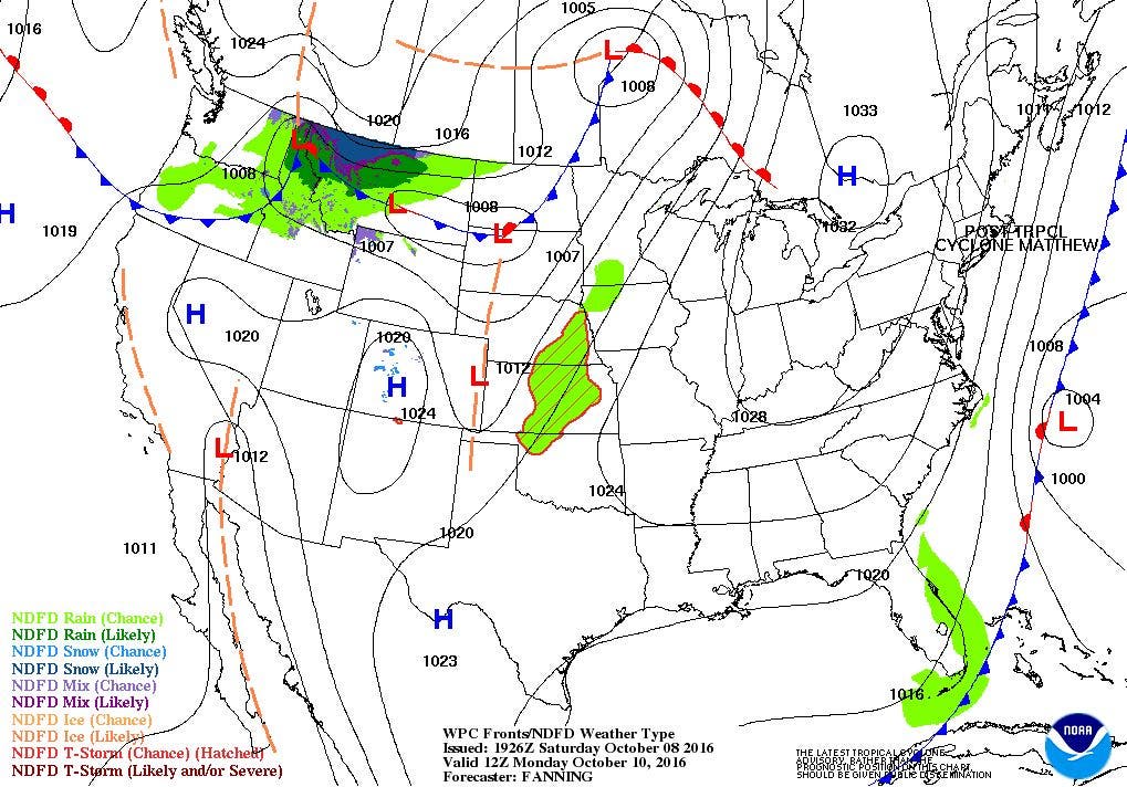
After some dense fog Saturday morning, the fog burned off, with partial sunshine coming through the overcast skies. The moisture to produce the cloud cover is coming from not only a cold front in central New York and Pennsylvania, but also shower activity from Matthew. In fact, radar imagery shows bands of showers reaching southern Connecticut. We will see gray skies for the next 24 hours, before come back to several days of drier air and sunshine.
We will begin to see some isolated showers move over the state by around 10 p.m. The cold front should be just west of over Rhode Island by that time, and we will return to patchy fog. Showers will become scattered after 2 a.m., as the front passes through the state. Low temperatures will fall into the upper 50’s. Any showers we receive through Sunday afternoon will come from the northern fridge of rain bands associated with Matthew. Also, winds will pick up slightly by the afternoon from the north, due to a pressure gradient forming. It will be due to a shorter distance from a high pressure system centered over Canada, along with the center of Matthew. As Matthew moves further out to sea, the pressure gradient will weaken. High temperatures on Sunday will only be in the lower 60’s, with partly cloudy skies Sunday night. Low temperatures will fall into the middle 40’s.
Find out what's happening in East Providencefor free with the latest updates from Patch.
It will be nice for Columbus Day, albeit a little cooler than normal. Expect sunny skies, but high temperatures will only reach the upper 50’s, so keep a jacket handy. Monday night will be partly cloudy, with lows in the lower 40’s. High pressure will remain right over New England into Wednesday night. So, expect sunny skies on Tuesday, with highs in the lower 60’s. We keep partly cloudy skies Tuesday night, with lows in the upper 40’s. With winds turning more to the southeast Wednesday, we will see some more moisture in the atmosphere. So, we will see increasing clouds through the late afternoon, with highs in the middle 60’s. Patchy fog is expected after 10 p.m. Wednesday night, with mostly cloudy skies and lows in the lower 50’s.
A cold front will be making its way into the Great Lakes by Thursday morning, so we will keep more clouds than sun in the forecast, with daytime highs in the upper 60’s. The front may bring some showers by the middle of the evening commute, before the front passes to our east by 8 p.m. There may be some passing showers until 2 a.m., before a new high pressure system brings drier air behind the front. Low temperatures will fall into the lower 50’s. High pressure will keep us under its influence right into the end of the week. Mostly sunny skies are expected for Friday and next Saturday. High temperatures will be in the lower 60’s on both days, with lows in the middle to upper 40’s.
Find out what's happening in East Providencefor free with the latest updates from Patch.
Tropical Update: Hurricane Matthew did a great amount of damage along the Florida shoreline on Friday, but the strongest winds stayed offshore. The center literally hugged right along the coastline, as it traveled north. At one point, about 1.05 million people in Florida were without power. Going into Saturday morning, states like Georgia, South Carolina, and North Carolina are now dealing with the brunt of this system. At this moment, rainfall rates of 2 to 3 inches per hour are falling in southern South Carolina and North Carolina. The National Weather Service office in Raleigh, N.C. are concerned with roads completely washing out, along with the threat of some dams failing. Wind gusts from Matthew have ranged from 60 mph in Orlando, to as high as 96 mph in Tybee Island, Georgia. Right now, 574,000 are without power in South Carolina. Matthew did make landfall southeast of McClellanville, S.C. Saturday morning.
As of 2 p.m. Saturday, Matthew was centered right over Myrtle Beach, S.C. with maximum sustained winds of 75 mph. It is moving to the northeast at 12 mph. The system will quickly move south of the Outer Banks by 8 a.m. Sunday. The system will then move south after 36 hours, and will dissipate into a remnant low with 72 hours.
Meanwhile, Tropical Storm Nicole will quickly move northwest after Monday. Now that the system will have a frontal boundary in the Atlantic Monday, the system will quickly speed up, and move northwest of Bermuda by 2 a.m. Thursday morning.
Jim Laurie is a local meteorologist who earned a B.S. in Meteorology at Lyndon State College in Lyndonville, VT. Jim has fifteen years of professional experience, with eight years in the field of marine meteorology.


