Weather
Rhode Island Gets Break with Hurricane Matthew
Southern New England may have been receiving some weather from Matthew by Saturday night. But, the models made a big change last night.

Weather Forecast Discussion for Rhode Island on October 6, 2016
I am just writing briefly today to update everyone on the new forecast track of Hurricane Matthew. During Tuesday evening, the National Hurricane Center made a drastic change, as many computer models began shifting Matthew more out into the Atlantic after 72 hours. There are some meteorological reasons behind this forecast.
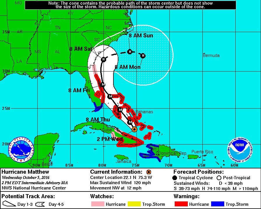
As of 2 p.m. Wednesday, the newest forecast has Matthew passing right through the middle of the Bahama Islands from 9 p.m. Wednesday through Thursday evening. The track has the center no more than about 5-10 nautical miles away from the Florida coastline at 8 a.m. Friday. With the cone of uncertainity, there remains a strong possibility that central Florida may still have Matthew making landfall. The system literally goes up the eastern coastline towards the Georgia-South Carolina border around 4 a.m. Saturday morning.
Find out what's happening in East Providencefor free with the latest updates from Patch.
The most drastic change in the forecast in the last 24 hours is after Saturday morning. Instead of Matthew continuing up to the northeast, a strong high pressure system out of the eastern Great Lakes moves east. Since everything in the atmosphere moves towards lower pressure, Matthew will become “stuck”. Matthew will not have an avenue to make any progress further north, since there is no cold front, or any type of frontal boundary. Also, in the upper levels of the atmosphere, there are no winds to give Matthew any steering. In this case, it will move to the east-southeast by early next week, as the only feature in the Caribbean is Tropical Storm Nicole.
Now, this is great news for Rhode Island and Southern New England. It takes us out of a lot of dangerous weather. However, we will still see some rough surf and high seas towards our south coast. This will also create moderate rip tides at our beaches. This activity will probably begin by Monday afternoon.
Find out what's happening in East Providencefor free with the latest updates from Patch.
For anyone who has to travel to the Southeast U.S., you may want to begin making contingency plans. There is already a state of emergency from Florida to North Carolina along the coastline. Evacuations for the coastline in these states are in progress or will begin by tomorrow.
I will continue to monitor Hurricane Matthew, and provide you with a full seven day forecast for Rhode Island by Thursday afternoon.
Jim Laurie is a local meteorologist who earned a B.S. in Meteorology at Lyndon State College in Lyndonville, VT. Jim has fifteen years of professional experience, with eight years in the field of marine meteorology.


