Weather
Nice, autumn weather in store for Friday and Saturday; Still determining Hermine's track and forecast for the weekend
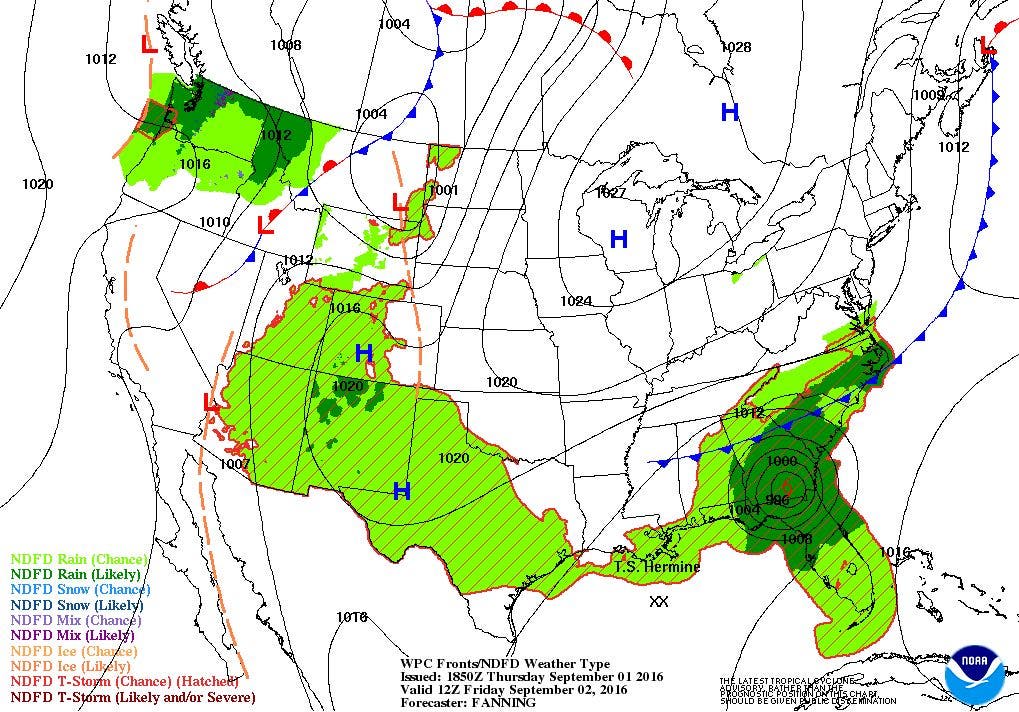
The first half of the holiday weekend looks spectacular. However, Tropical Storm Hermine will greatly effect the second half of the weekend.


Weather Forecast Discussion for Rhode Island on September 2, 2016
At the moment, the rain we are receiving over the Ocean State Wednesday is really due to a passing cold front. The precipitation is not coming from any of the tropical systems you may have heard of over the last 48 hours. However, I was concerned with now Tropical Storm Hermine in the last discussion affecting our Labor Day Weekend. Now, it seems we will definitely see some weather from the storm, but to what extent?
At the moment, the latest radar imagery shows the heaviest rainfall now moving towards the Cape and Islands. There is also a line of thunderstorms forming west of Worcester, MA. So, we may see a passing shower or thunderstorm in the state into this evening. We will begin to see clearing skies after midnight, once the front moves offshore. The humidity will also lower, as temperatures fall into the lower 60’s. However, if you plan on travelling to the Cape and Islands tonight to avoid the holiday weekend traffic, you may still experience moderate rain and patchy fog through the evening.
Find out what's happening in East Providencefor free with the latest updates from Patch.
The first half of the holiday weekend looks sensational. High pressure coming down from central Canada will provide us with sunny skies and cool temperatures. High temperatures will be in the upper 70’s. You can keep your windows open Friday night, as we will have partly cloudy skies and low temperatures near 60. Saturday looks just fine as well, with mostly sunny skies and highs in the middle 70’s. We will begin to see increasing clouds entering Saturday night, as Hermine is forecast to be centered off the Mid-Atlantic coastline. Low temperatures will remain in the upper 50’s to lower 60’s.
Now, as we enter Sunday, this is where all the forecasts go in different directions. Due to the uncertain track of what will be the remnants of Hermine, the chance for seeing some rainfall goes anywhere from 8 a.m. Sunday to as late as Sunday night. The south coast will see increasing winds and seas by early Sunday morning, as Hermine looks to be becoming stationary. Also, high surf and rip tides will increase as well, so we will become more dangerous being in the waters of any state beach. Looking over the models, I feel we will see the south coast seeing rainfall by the late morning, and moving north. We will see moderate to heavy rain at times in Providence by the mid-afternoon, with strong winds. The system will actually move southward during Sunday night, so winds will remain breezy, with gusts still near tropical storm strength. The conditions will not improve for Labor Day, as Hermine remains stationary. However, what’s left of Hermine will begin to weaken by Monday night, and begin to move off to the south and east. Winds will diminish, but light to moderate rain will continue, especially along the Cape and Islands. High temperatures Sunday and Monday will be in the lower 70’s, with lows in the middle 60’s. The good news for the south coast is we will not see coastal flooding, as we will be astronomical low tide over the next few days.
Find out what's happening in East Providencefor free with the latest updates from Patch.
The models even disagree on whether we receive precipitation on Tuesday. The American model has the remnants of Hermine further east than the European model. The European model keeps the low south of Long Island Sound, giving us the risk for more showers. At this time, I believe the American model is correct, as there will be no blocking feature for the low to keep it stationary. We will see any showers end by the morning, with a mix of sun and clouds by the afternoon. Expect high temperatures in the upper 70’s.
By Wednesday, high pressure over the Southeast U.S. will begin to influence our weather. With an upper level ridge moving over the eastern U.S., we will return more to summer than astronomical fall. We will see mostly sunny skies, but high temperatures will increase into the lower 80’s. It will be partly cloudy Wednesday night, but we will have to use those air conditioners and fans again, as overnight lows only fall into the upper 60’s. On next Thursday, we will see partly to mostly sunny skies, with daytime highs in the middle 80’s. This will be about 10 degrees above where we should be for this time of the year. Clouds will be increasing through the afternoon, as a cold front will bring the risk for showers and thunderstorms next Thursday night.
Tropical Update: Gaston is not a threat, and Tropical Depression Eight dissipated as of 5 a.m. Thursday morning. So, we will just concentrate on now Hurricane Hermine. As of 2 p.m., Thursday, Hermine was centered about 125 miles southwest of Apalachicola, FL, with maximum sustained winds of 70 mph. This is just below hurricane strength. It is moving off to the north-northeast at 14 mph. The forecast is for Hermine to remain a category 1 hurricane, and make landfall after midnight. Hermine will remain over land into Saturday, staying along southeast Georgia and southeast South Carolina. It reaches eastern North Carolina by Saturday morning. It will then return over the waters of the Atlantic and remain offshore of the Mid-Atlantic region Sunday into Labor Day morning. Because it reached the mid-latitudes, the system will be known as Post Tropical Hermine. There will be wind speeds as high as 50 mph around the center, but as the system becomes stationary, that wind field will expand out. So, seas could become quite choppy and heavy along the south shore of Rhode Island Sunday and Monday. Unfortunately, the forecast track is still highly in flux. So, it is still difficult to determine the weather for Sunday and Monday in terms of Rhode Island. I will have another forecast update on Saturday.
First Pitch Forecast (for McCoy Stadium, home of the Pawtucket Red Sox):
Sept. 2nd vs. Syracuse (7:05 p.m.): Partly cloudy, 70.
Sept. 3rd vs. Syracuse (7:05 p.m.): Partly cloudy, 67.
Jim Laurie is a local meteorologist who earned a B.S. in Meteorology at Lyndon State College in Lyndonville, VT. Jim has fifteen years of professional experience, with eight years in the field of marine meteorology.


