Weather
Nice weather continues into Saturday, with much needed rainfall Sunday and Monday; dry weather returns on Tuesday.
After hitting 90 degrees on Wednesday, we reached the 70's since Friday. But, the humidity will return, with rain arriving on Sunday.

Weather Forecast Discussion for Rhode Island on September 17, 2016
After going over 90 degrees on Wednesday, it has felt like a totally different season. So far, high temperatures Thursday and Friday only reached the lower 70’s, with lows in Providence falling to 50 degrees last night. Although we will not see temperatures again in the 90’s, dewpoint temperatures will be rising by tomorrow. This will make the weekend feel quite humid.
At the moment, high pressure over the Atlantic is keeping a strong ridge over Southern New England. Any cloud cover coming from the northeast winds off the ocean will melt away, especially after the sun sets. So, we will see clear skies after midnight. Low temperatures will fall into the lower 50’s in the urban areas. But, if you will be interior southeast Massachusetts, low temperatures will fall to 40-45 degrees. By Saturday, the ridge will weaken, as a cold front approaches the east coast. We will have highs in the middle 70’s, along with the dewpoint temperatures rising. Skies will become mostly cloudy Saturday night, as the low’s center moves into Quebec, Canada. We may see a passing shower after 4 a.m. Also, with the dewpoints in the lower to middle 60’s, we will see patchy fog develop. Look for low temperatures in the middle 60’s.
Find out what's happening in East Providencefor free with the latest updates from Patch.
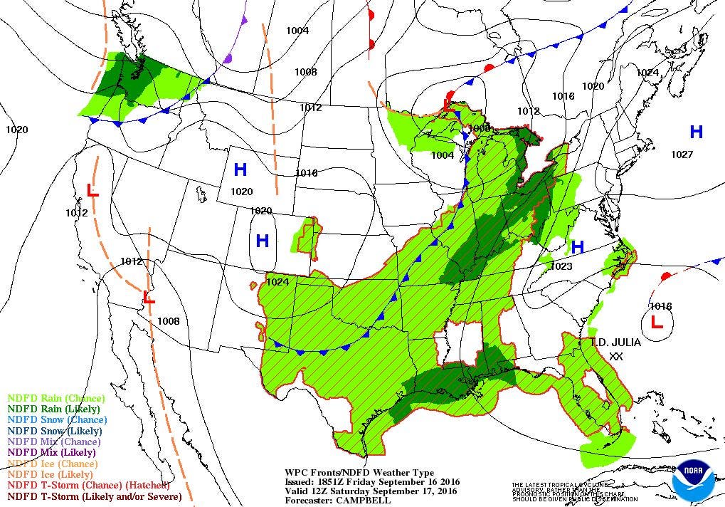
We will see the risk for heavier rainfall and isolated thunderstorms increase through Sunday morning, as precipitation is expected to move over the Ocean State. There is the chance for some areas to see heavy rainfall, especially during the afternoon and early evening. So, bring a poncho or raincoat if you happen to be heading up to Gillette Stadium in Foxboro for the Patriots home opener at 1 p.m. We will also see patchy fog develop, as the dewpoints stay in the upper 60’s. Look for high temperatures to reach the upper 70’s. We will continue to see scattered showers and an isolated thunderstorm Sunday night, as the moisture from the remnants of Julia moves north. Look for low temperatures to be in the upper 60’s.
A secondary low will form over Quebec on Monday, helping the atmosphere to stay unstable. This low will help enhance more showers through the day, with an isolated thunderstorm possible. High temperatures will only reach the middle 70’s. The low moves towards Nova Scotia Monday night, and all shower activity will come to an end before 9 p.m. Skies will be cloudy until midnight, before skies begin to clear. Look for low temperatures in the middle 60’s.
Find out what's happening in East Providencefor free with the latest updates from Patch.
High pressure will slowly move out of the Central Plains into the Mid-Atlantic Tuesday and Wednesday. So, we will return to dry weather, with mostly sunny to sunny skies. High temperatures will range from the upper 70’s to lower 80’s both days, with low temperatures ranging in the upper 50’s to lower 60’s. By Thursday night, that high will move into the Atlantic, and be replaced by a stronger high coming out of central Canada. With an upper level ridge to the west of us, temperatures will remain in the upper 70’s into next Friday under sunny skies, and lows in the upper 50’s to lower 60’s.
Tropical Update: In the last discussion, we were watching three different tropical systems in the Atlantic. Since then, Post-Tropical Cyclone Ian was 795 miles east of Cape Race, Newfoundland. The last advisory for the system was put out by the National Hurricane Center at 11 a.m. Friday. Meanwhile, Tropical Storm Julia continues to spin and meander off the coast of North Carolina. As of 11 a.m., Julia was centered about 240 miles southeast of Cape Fear, North Carolina, with maximum sustained winds of 40 mph. The forecast is for Julia to simply remain quasi-stationary, before moving north Sunday morning. It will weaken, and become a remnant low by Monday morning. It will be taken out to sea by the cold front that will bring us rain Sunday and Monday.
Finally, Tropical Depression Twelve was upgraded, and become Tropical Storm Karl. As of 11 a.m., Karl was centered 700 miles west-northwest of the Cabo Verde Islands. Maximum sustained winds are 45 mph, and is moving west-northwest at 13 mph. The forecast is for Karl to begin strengthening after Sunday night. The track has the system eventually moving northwest and away from the islands and Puerto Rico. It is forecast to become a hurricane before 120 hours, but not pose a threat to any island or mainland. However, it will create powerful seas and swells for St. Lucia, St. Croix, and Puerto Rico by Tuesday.
Jim Laurie is a local meteorologist who earned a B.S. in Meteorology at Lyndon State College in Lyndonville, VT. Jim has fifteen years of professional experience, with eight years in the field of marine meteorology.


