Weather
With one heat wave done, we may be starting a new one; hot temperatures expected next three days; strong storms tonight
A couple of fronts will bring the risk for more strong thunderstorms into the early evening; high pressure then takes over into Thursday.

Weather Forecast Discussion for Rhode Island on July 26, 2016
Well, the dog days of summer have arrived in the Ocean State. We had an official heat wave during Thursday through Saturday, as highs reached the lower to middle 90’s. On Sunday, the official high at T.F. Green Airport was 88 degrees, stopping the trend. But, on Monday, we already broke 91 degrees earlier in the day. In fact, a Heat Advisory is in effect for northwest Providence County until 6 p.m. tonight. As we progress through the week, is a new heat wave in store?
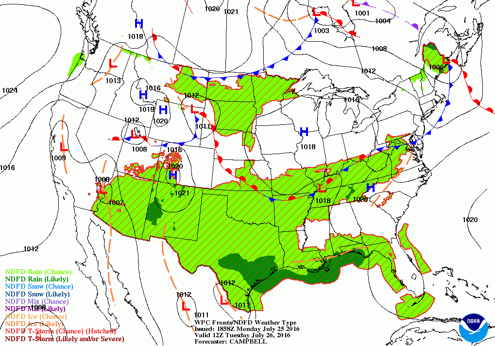
Right now, the first thing we need to watch is a warm front ready to move through Southern New England. This front is already creating strong thunderstorms over eastern New York. Within the next 3 hours, Rhode Island has a chance to see some strong thunderstorms. We may see strong wind gusts like we had on Saturday evening, or even some small hail, along with heavy downpours. The cold front will come through during the overnight. Some areas, like the Cape and Islands, will see patchy fog and low stratus clouds. Storms will weaken as the sun sets, and the cold front will move into eastern Massachusetts by 5 a.m. All precipitation ends after 2 a.m. with gradual clearing towards sunrise. Expect overnight lows to only fall into the lower 70’s.
Find out what's happening in East Providencefor free with the latest updates from Patch.
By Tuesday morning, a weak area of high pressure ridging will return us back to sunny skies. It will feel less humid, as winds turn to the northwest. But, it will remain hot, as daytime highs are forecast to reach the lower 90’s. This weak ridge will stay south and west of Southern New England Tuesday night, providing us with partly cloudy skies and lows near 70. This weak ridge continues to influence our weather into Wednesday, with sunny skies and high temperatures near 90. If we keep 90 degree weather on Tuesday and Wednesday, we will have another official heat wave in Rhode Island. Lows Wednesday night will be in the upper 60’s under clear to partly cloudy skies.
On Thursday, a very weak cold front in Northern New England will move south. We will have mostly sunny skies to start the day, with increasing clouds through the afternoon. We will see overcast skies by the evening commute, with the slight risk for a passing shower once the front arrives by 7 p.m. We should see high temperatures near 90 before the clouds take over the skies. A wave of low pressure forming over eastern North Carolina early Friday morning will help enhance the risk for some showers and thunderstorms. However, I still believe there is only a 20-30% chance for any precipitation. Overnight lows Thursday night are forecast to fall into the lower 70’s.
Find out what's happening in East Providencefor free with the latest updates from Patch.
The better chance for precipitation will be Friday. Although the American model has a low too far south and to the east, the European model keeps the low more over the Ohio River Valley. It will follow along a frontal boundary, and give us a better risk for showers and light rain by the late afternoon. Look for daytime highs Friday in the middle 80’s. We may see some sunshine from time to time, so I would not call Friday a “washout”. I see the small chance for passing showers Friday night, as the low works out to sea. We will still keep overcast skies with lows in the upper 60’s.
As we head into the weekend, the models continue to further diverge away from one another. The American model is more optimistic, with high pressure ridging from the northwest completely clearing our skies. But, the European and United Kingdom models keep a low pressure system over New York at 8 a.m. Saturday morning or well south of us, respectively. I am a little sheepish on trusting the American model at the moment. For now, I will call for more clouds than sunshine with the risk for passing showers, especially during the morning hours. Highs on Saturday will only reach the lower to middle 80’s, with overnight lows Saturday night in the upper 60’s. As we enter Sunday, moisture from the south will help enhance the risk for passing showers along a weak cold front. We will see the risk for more showers during the morning and afternoon, before the front moves offshore Sunday night. Daytime highs will reach the lower 80’s, with overnight lows in the middle 60’s. High pressure coming down from Halifax, Nova Scotia will return us to mostly sunny skies next Monday, with highs in the lower 80’s.
First Pitch Forecast (for McCoy Stadium, home of the Pawtucket Red Sox):
July 25th vs Rochester (7:05 p.m.): Chance of passing showers/t-storms, 84.
July 26th vs. Rochester (7:05 p.m.): Partly cloudy, 85.
Jim Laurie is a local meteorologist who earned a B.S. in Meteorology at Lyndon State College in Lyndonville, VT. Jim has fifteen years of professional experience, with eight years in the field of marine meteorology.


